Supercharge Your Innovation With Domain-Expert AI Agents!

Short-distance navigation method in region without navigation information

A technology of navigation information and navigation method, applied in the field of navigation, can solve problems such as loss of navigation ability, difficulty in obtaining geographic information, and inability to have offline navigation functions of navigators, so as to avoid navigation and deviation correction from being out of sync with reality and improve accuracy Effect

Pending Publication Date: 2020-02-28
湖南易见源科技有限公司
View PDF5 Cites 0 Cited by
  • Summary
  • Abstract
  • Description
  • Claims
  • Application Information

AI Technical Summary

Problems solved by technology

[0002] Navigation can be simply described as moving in a direction according to a line segment, but this is an ideal state. In real life, there are many force majeure factors that can cause navigation errors, such as temporary deviation from the route, road maintenance, traffic accidents, and changes in passing areas. etc. To correct this error, it is necessary to combine the location points into an area surface, and calculate the appropriate route in real time and efficiently according to the relationship between the coordinates that need to be navigated and the current area surface
[0003] At present, whether it is a professional navigator or a navigation app for a smart device, it is necessary to download the specified software, especially some navigation apps, which occupy a large memory space of the smart device, and users are unwilling to use such apps. When navigating, the native application of the smart device will be used for navigation, such as using the web map that comes with the browser or the internal applet of WeChat, etc., but this navigation method cannot realize the import of external data for navigation route calculation. When entering In unconventional areas, such as scenic spots or communities that do not record detailed routes, it is often necessary to ask people or use paper maps to find the actual location, and it is even more difficult to obtain corresponding geographic information in remote mountainous areas
Offline navigation is also a very important part. In reality, it often happens that the network cannot be connected during navigation. If you use web navigation at this time, you will not be able to have the offline navigation function of the navigator or navigation APP, and lose the navigation ability.

Method used


Image

  • Short-distance navigation method in region without navigation information

Examples


Embodiment Construction

[0027] The following will clearly and completely describe the technical solutions in the embodiments of the present invention with reference to the accompanying drawings in the embodiments of the present invention. Obviously, the described embodiments are only some, not all, embodiments of the present invention. Based on the embodiments of the present invention, all other embodiments obtained by persons of ordinary skill in the art without making creative efforts belong to the protection scope of the present invention.

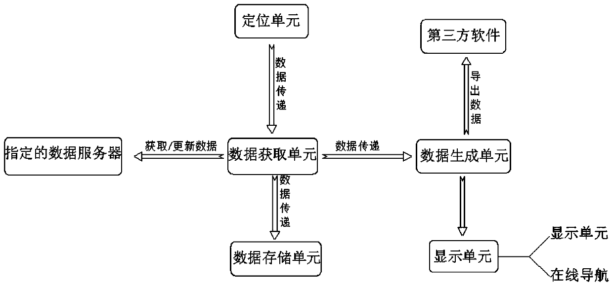
[0028] see figure 1 , an embodiment provided by the present invention: a short-distance navigation method in an area that does not contain navigation information, including the use of the positioning unit to obtain the current location information of the user, and the location information is fed back to the data acquisition unit, and the data acquisition unit according to the current user The data server designated by the coordinate information request obtains...


PUM


Abstract

The invention discloses a short-distance navigation method in a region without navigation information. The short-distance navigation method comprises a positioning unit, wherein the positioning unit acquires current position information of a user; a data acquisition unit acquires data information of a corresponding format; the data acquisition unit transmits the information to a data generation unit; the information of the data acquisition unit and navigation route information are simultaneously transmitted to a data storage unit for storage; and the navigation route information is displayed by means of a display unit, the user selects a navigation route for navigation, and data updating is performed by means of a far-end auxiliary unit. According to the short-distance navigation method, the user knows his / her position through positioning, short-distance navigation on applications such as browser webpages and APP applets can be realized under offline or intolerant factors in the process of route and error correction, a user-defined navigation function is achieved, the navigation data of the user can be stored locally and used for offline navigation in an offline state, the data synchronization with services can be dynamically carried out in an online state, and related data can be provided for a third party for navigation.

Description

technical field [0001] The invention relates to the technical field of navigation, in particular to a short-distance navigation method in areas not containing navigation information. Background technique [0002] Navigation can be simply described as moving in a direction according to a line segment, but this is an ideal state. In real life, there are many force majeure factors that can cause navigation errors, such as temporary deviation from the route, road maintenance, traffic accidents, and changes in passing areas. etc. To correct this error, it is necessary to combine the location points into an area surface, and calculate the appropriate route in real time and efficiently according to the relationship between the coordinates that need to be navigated and the current area surface. [0003] At present, whether it is a professional navigator or a navigation app for a smart device, it is necessary to download the specified software, especially some navigation apps, which ...

Claims


Application Information

Patent Timeline
Patent Type & Authority Applications(China)
IPC IPC(8): G01C21/20G01C21/34
CPCG01C21/20G01C21/3415
Inventor 刘永华王琼首刘雪华龙勇黄许江刘群左向荣张鑫雨肖文军
Owner 湖南易见源科技有限公司
Features
  • R&D
  • Intellectual Property
  • Life Sciences
  • Materials
  • Tech Scout
  • Unparalleled Data Quality
  • Higher Quality Content
  • 60% Fewer Hallucinations
Learn More