Method and device for generating digital surface model

A surface model and digital technology, applied in the field of geographic information, can solve the problems of high inaccuracy of digital surface model and low accuracy of digital surface model

Active Publication Date: 2020-03-17
BEIJING UNIV OF CIVIL ENG & ARCHITECTURE
View PDF3 Cites 6 Cited by
  • Summary
  • Abstract
  • Description
  • Claims
  • Application Information

AI Technical Summary

Problems solved by technology

[0004] The purpose of the present invention is to provide a method and device for generating a digital surface model to solve the problem that the existing digital surface model is generated by point clouds using interpolation algorithms. Wh

Method used


Image

  • Method and device for generating digital surface model
  • Method and device for generating digital surface model
  • Method and device for generating digital surface model

Examples


Embodiment Construction

[0071] The technical solutions in the embodiments of the present invention will be clearly and completely described below in conjunction with the accompanying drawings in the embodiments of the present invention. Obviously, the described embodiments are only some, not all, embodiments of the present invention. Based on the embodiments of the present invention, all other embodiments obtained by persons of ordinary skill in the art without creative efforts fall within the protection scope of the present invention.

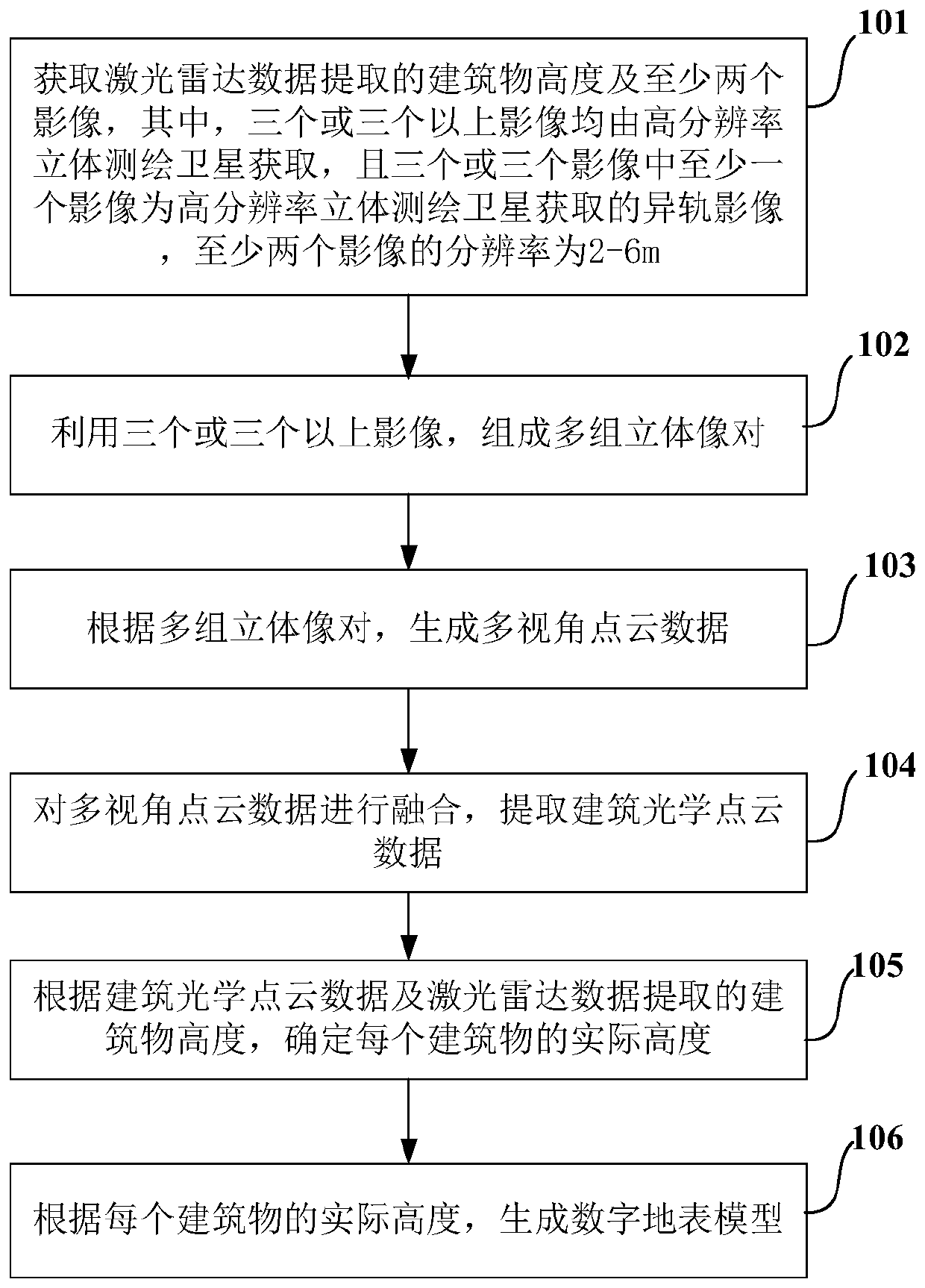
[0072] First aspect, such as figure 1 As shown, an embodiment of the present invention provides a method for generating a digital surface model, including:

[0073] Step 101: Obtain the height of the building extracted from the lidar data and three or more images, wherein the three or more images are all obtained by high-resolution stereoscopic mapping satellites, and at least one of the three or more images One image is an off-orbit image acquired by a high-resolut...


PUM


Abstract

The invention discloses a method and device for generating a digital surface model, and the method comprises the steps: forming a plurality of groups of stereo image pairs through three or more than three images with the resolution of 2-6m, at least one image being a different-orbit image obtained by a high-resolution stereo surveying and mapping satellite; generating multi-view point cloud data according to the plurality of groups of stereo image pairs; fusing the multi-view point cloud data, and extracting building optical point cloud data; determining the actual height of the building by utilizing the building height extracted from the building optical point cloud data and a small amount of laser radar data; and fusing the point cloud and the building height by utilizing the stereopairto generate an urban digital surface model. The digital earth surface model generated by the method does not need a high-resolution image with the resolution less than or equal to 1m; and the actual height of the building is determined by utilizing the building height extracted from the building optical point cloud data and the laser radar data, and the precision of the height of the digital surface model is improved, so that the accuracy of the digital surface model is improved.

Description

technical field [0001] The invention relates to the technical field of geographic information, in particular to a method and device for generating a digital surface model. Background technique [0002] Terrain models of geographic regions can be used in many fields, for example, terrain models can be used in flight simulations and in planning military missions. In addition, terrain models of human structures such as cities are very helpful for cellular antenna placement, disaster preparedness and analysis and mapping applications. [0003] Various types and methods for making terrain models are currently in use, one common terrain model is a digital surface model (DSM). Digital surface models can be generated from existing digital topographic maps, or extracted from aerial photographs, optical satellite imagery pairs, or using laser scanning. Existing satellite stereo image pairs extract building target heights in units of image pixels, and digital surface models are mostl...

Claims


Application Information

Patent Timeline
IPC IPC(8): G06T17/05G06T15/00G01S17/89
CPCG06T17/05G06T15/00G01S17/89
Inventor 曹诗颂杜明义彭自强蔡一乐张朝胤
Owner BEIJING UNIV OF CIVIL ENG & ARCHITECTURE
Why Eureka
Try Eureka