Surveying and mapping instrument adjusting device for engineering

A technology for adjusting devices and instruments, which is applied in the direction of supporting machines, mechanical equipment, machines/stands, etc. It can solve the problems of poor adjustment of the rotation angle, insufficient height of the instrument, inconvenient use, etc., and achieve continuous and stable power supply process and angle adjustment. The effect of accurate process and stable height adjustment process

Active Publication Date: 2020-04-10
涟水县勘察测绘有限公司
View PDF8 Cites 11 Cited by
  • Summary
  • Abstract
  • Description
  • Claims
  • Application Information

AI Technical Summary

Problems solved by technology

[0002] Surveying and mapping instruments are instruments and devices designed and manufactured for surveying and mapping operations such as data acquisition, processing, and output, including various orientation, ranging, and Angle, height measurement, mapping and photogrammetry, etc., in the process of using surveying and mapping instruments, the instrument is often deflected, the height of the instrument is not enough, and the rotation angle is not easy to adjust. It needs to be adjusted with the help of engineering surveying and mapping instrument adjustment devices. The traditional engineering surveying and mapping instrument adjustment device has single function and poor stability, so it is not convenient to use in the field surveying and mapping process
[0003] Chinese patent (notification number CN208476251U) discloses an engineering surveying and mapping instrument adjustment device, although it can be improved to address the above problems, but in terms of multi-terrain adaptive support, stable clamping and fixing, height adjustment angle adjustment, and stable power supply There are deficiencies

Method used


Image

  • Surveying and mapping instrument adjusting device for engineering
  • Surveying and mapping instrument adjusting device for engineering
  • Surveying and mapping instrument adjusting device for engineering

Examples


Embodiment 1

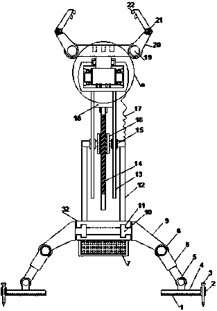
[0024] see Figure 1~3 , in an embodiment of the present invention, an engineering surveying and mapping instrument adjustment device includes a support mounting plate 32 arranged horizontally, a storage battery 7 is horizontally provided on the lower side of the support mounting plate 32, and a support mounting plate 32 is vertically provided on the upper end of the support mounting plate 32 The cylinder 12, the edge of the supporting mounting plate 32 is provided with a limit rotation groove 11, and a number of limit rotation columns 10 are arranged at an equal angle with the limit rotation groove 11, and the outer ends of the limit rotation columns 10 are provided with rotation support columns 9 , the rotating supporting columns 9 are all inclined downwards, and the lower ends of the rotating supporting columns 9 are provided with a swinging telescopic column 6 through a damping shaft 8, and the lower ends of the swinging telescopic column 6 are provided with a swinging supp...

Embodiment 2

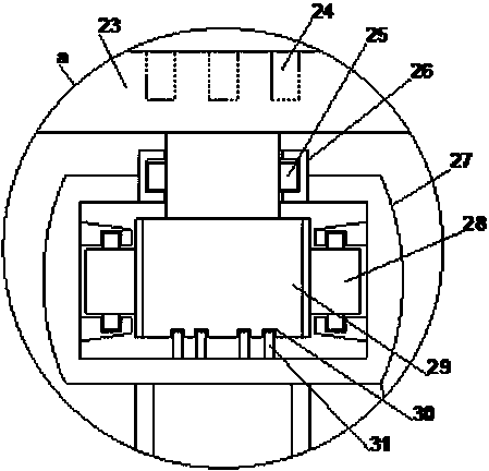
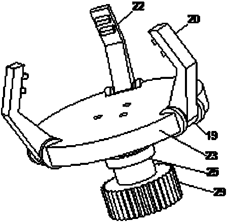
[0027] On the basis of Embodiment 1, the fixed mounting cylinder 2 cooperates with the fixed ground pin 3 to achieve fast fixing, which significantly improves the fixing stability of the device. Through the functions of the three positioning mounting grooves 24 and the fixing teeth 22, the installation of the surveying and mapping instrument Stable, through the cooperation of the limit bearing sleeve 26 and the limit rotating shaft 25, the rotation process of the rotating mounting plate 23 is stabilized, while the steering gear 29 rotates, the rotating conductive ring 31 and the annular conductive groove 30 are rotated and coupled to supply power, so that the power supply of the device The process is continuous and stable.


PUM


Abstract

The invention relates to the field of surveying and mapping equipment, in particular to a surveying and mapping instrument adjusting device for engineering. The device comprises a horizontally arranged supporting mounting plate, wherein a storage battery is horizontally arranged at the lower side of the supporting mounting plate, a supporting mounting cylinder is vertically arranged at the upper end of the supporting mounting plate, limiting rotating grooves are formed in the edge of the supporting mounting plate, a plurality of limiting rotating columns are arranged at equal angles in cooperation with the limiting rotating grooves, the outer ends of the limiting rotating columns are all provided with rotating supporting columns, and a lifting mounting cylinder is arranged right above thesupporting mounting cylinder. The device can be subjected to multi-angle support adjustment through a turning swing supporting structure, support under a complex working environment is adapted, and asurveying and mapping instrument is always in an optimal station state; the height adjustment process of the device is stable through a lifting structure of threads and screw rods and in cooperation with a lifting guide structure; and gear engagement is used for transmission, and in cooperation with rotating coupling power supply, the angle adjustment process of the surveying and mapping instrument is accurate, and the power supply process is continuous and stable.

Description

technical field [0001] The invention relates to the field of surveying and mapping equipment, in particular to an engineering surveying and mapping instrument adjustment device. Background technique [0002] Surveying and mapping instruments are instruments and devices designed and manufactured for surveying and mapping operations such as data acquisition, processing, and output, including various orientation, ranging, and Angle, height measurement, mapping and photogrammetry, etc., in the process of using surveying and mapping instruments, the instrument is often deflected, the height of the instrument is not enough, and the rotation angle is not easy to adjust. It needs to be adjusted with the help of engineering surveying and mapping instrument adjustment devices. The traditional engineering surveying and mapping instrument adjustment device has single function and poor stability, so it is not convenient to use in the field surveying and mapping process. [0003] Chinese...

Claims


Application Information

Patent Timeline
IPC IPC(8): F16M11/04F16M11/08F16M11/18F16M11/28
CPCF16M11/041F16M11/08F16M11/18F16M11/28
Inventor 濮更生徐永文肖金城吴建成朱伟平郑兆荣周学军
Owner 涟水县勘察测绘有限公司
Why Eureka
Try Eureka