
Mountain fire synchronous satellite monitoring and early warning method and system based on time scale feature evaluation

A synchronous satellite, time-scale technology, applied in fire alarms, fire alarms, radio relay systems and other directions that rely on radiation, can solve the problem of low recognition rate of mountain fires, achieve clear thinking, reduce tripping accidents, Easy-to-use effects

Pending Publication Date: 2020-04-14
STATE GRID HUNAN ELECTRIC POWER +2
View PDF0 Cites 4 Cited by
  • Summary
  • Abstract
  • Description
  • Claims
  • Application Information

AI Technical Summary

Problems solved by technology

[0004] Aiming at the problem of low recognition rate of mountain fires in a small area of ​​geostationary satellites, different from traditional mountain fire satellite monitoring and identification methods that only analyze adjacent pixels on a spatial scale, the present invention proposes a method of mountain fire synchronous satellite monitoring based on time-scale feature evaluation The early warning method and system can effectively and accurately propose small-area initial wildfire pixels in the mid-synchronous satellite images, effectively improve the accuracy of transmission line wildfire identification, and reduce tripping accidents

Method used


Image

  • Mountain fire synchronous satellite monitoring and early warning method and system based on time scale feature evaluation
  • Mountain fire synchronous satellite monitoring and early warning method and system based on time scale feature evaluation
  • Mountain fire synchronous satellite monitoring and early warning method and system based on time scale feature evaluation

Examples


Embodiment 1

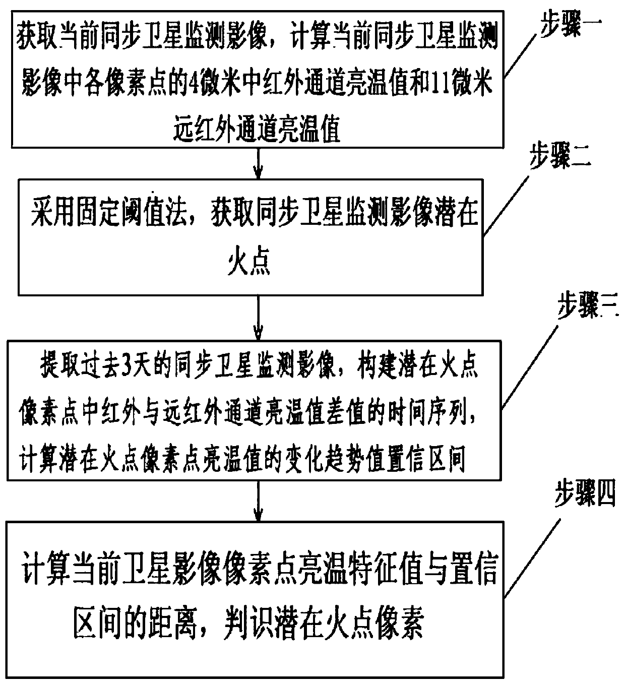
[0047] (1) Obtain the China Fengyun-4 synchronous satellite monitoring image received at 10:15 am Beijing time on the morning of Qingming Festival on April 5, 2019, and calculate the 4-micron mid-infrared channel brightness temperature of each pixel in the current synchronous satellite monitoring image value and 11 micron far-infrared channel brightness temperature value;

[0048] (2) Using the fixed threshold method, where and ΔT * According to the temperature of the day is set to 312K and 15K respectively, the potential fire points of the geostationary satellite monitoring images are calculated;

[0049] (3) Extract 287 geostationary satellite monitoring images in the past 3 days

[0050] Image, construct the time series of the difference between the brightness temperature values ​​of the mid-infrared and far-infrared channels of the potential fire point pixels, and calculate the confidence interval of the change trend value of the lighting temperature value of the potent...

Embodiment 2

[0053] An embodiment of a mountain fire synchronous satellite monitoring and early warning system based on time-scale feature evaluation of the present invention includes a memory, a processor, and a computer program stored in the memory and operable on the processor. When the processor executes the computer program Realize the steps of Embodiment 1 of this method.

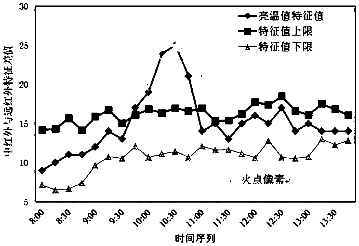
[0054] It can be seen that, using the calculation method of the above-mentioned mountain fire synchronous satellite monitoring and early warning method based on time-scale feature evaluation, through the sudden change detection of the same pixel lighting temperature value in multiple satellite monitoring images, the change trend of pixel lighting temperature value is used The value confidence interval is used as the judgment of the characteristics of the fire point, which can detect the small-area initial mountain fire pixel points in a more timely manner, and win sufficient preparation time for on-site fire fighti...


PUM


Abstract

The invention discloses a mountain fire synchronous satellite monitoring and early warning method and system based on time scale feature evaluation. Satellite monitoring image time scale characteristic analysis is introduced into mountain fire monitoring identification. According to the method, mutability detection is carried out on the same pixel lighting temperature value in multiple satellite monitoring images; a change trend value confidence interval of the pixel lighting temperature value is adopted as judgment of fire point characteristics; the distance between a pixel lighting temperature characteristic value at the current moment and the confidence interval is calculated; and whether a pixel point is a fire point or not is judged. Different from a traditional mountain fire satellite monitoring and recognition method which only analyzes adjacent pixel points on the spatial scale, the method provided by the invention can effectively and accurately put forward small-area initial mountain fire pixel points in a middle-synchronous satellite image, is clear in thought, convenient to operate and high in practicability, can effectively improve the precision of mountain fire recognition of power transmission lines, and reduces mountain fire tripping accidents.

Description

technical field [0001] The invention belongs to the technical field of electric power engineering, and in particular relates to a mountain fire synchronous satellite monitoring and early warning method and system based on time scale feature evaluation. Background technique [0002] With the continuous expansion of UHV lines and cross-regional power grids in my country, transmission lines often need to pass through mountainous areas and agricultural areas, and the number of wildfires near line corridors continues to increase. After a wildfire occurs, atmospheric conditions such as temperature, density, and humidity will change significantly, greatly reducing the air insulation, and usually last for a long time, making it difficult to successfully reclose the line. At present, some achievements have been made in real-time monitoring of mountain fires on transmission lines, including meteorological satellite remote sensing, laser detection, smoke detection, and weather radar mo...

Claims


Application Information

Patent Timeline
IPC IPC(8): G06K9/00G06K9/46G08B17/12H04B7/19
CPCG08B17/125H04B7/19G06V20/188G06V10/56Y02D30/70
Inventor 李波章国勇周秀冬罗晶何立夫
Owner STATE GRID HUNAN ELECTRIC POWER
Learn More