Method for inverting ocean gravity field by using imaging type altimeter data

An altimeter and imaging technology, which is applied in the direction of measuring gravitational field, open-air water source survey, instrument, etc., can solve the problems of limited accuracy of marine gravity field and limited accuracy of vertical line deviation, etc., to weaken the influence of residual error correction, overcome defects, and improve The effect of overall accuracy

Active Publication Date: 2020-04-21
WUHAN UNIV +1
View PDF7 Cites 12 Cited by
  • Summary
  • Abstract
  • Description
  • Claims
  • Application Information

AI Technical Summary

Problems solved by technology

[0003] In view of the above defects or improvement needs of the prior art, the present invention proposes a method for inverting the ocean gravity field from imaging altimeter data, thereby solving the problem of the limited accuracy of the vertical line deviation calculated based on the sub-satellite point altimeter data, which leads to There are technical problems in the accuracy of the inverted ocean gravity field

Method used


Image

  • Method for inverting ocean gravity field by using imaging type altimeter data
  • Method for inverting ocean gravity field by using imaging type altimeter data
  • Method for inverting ocean gravity field by using imaging type altimeter data

Examples


Embodiment Construction

[0027] In order to make the object, technical solution and advantages of the present invention clearer, the present invention will be further described in detail below in conjunction with the accompanying drawings and embodiments. It should be understood that the specific embodiments described here are only used to explain the present invention, not to limit the present invention. In addition, the technical features involved in the various embodiments of the present invention described below can be combined with each other as long as they do not constitute a conflict with each other.

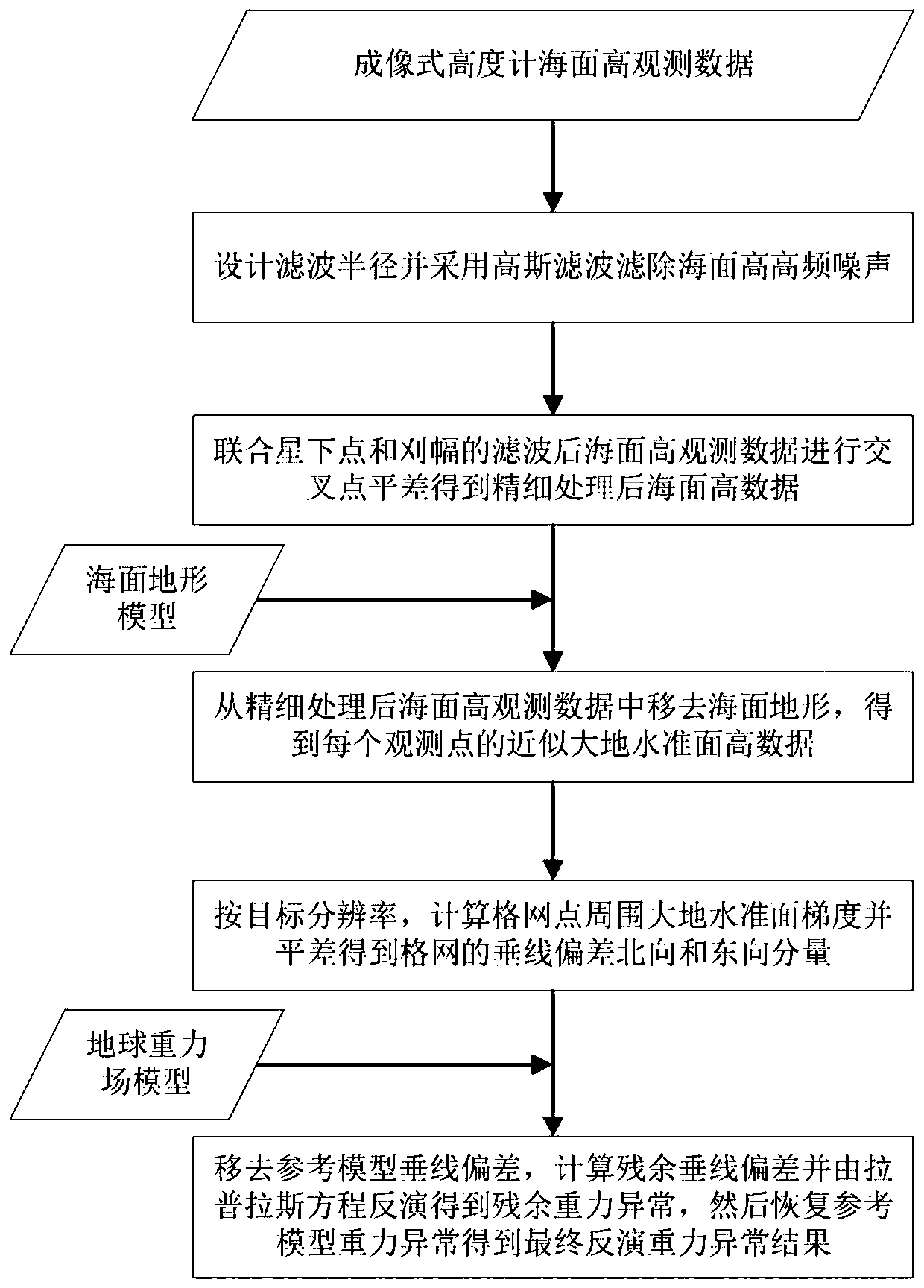
[0028] The imaging altimeter utilized in the present invention includes a synchronously observed sub-satellite point altimeter and wide-swath altimeters on both sides, which can obtain high-precision sea surface height observation data with high spatial resolution, and the observation data in the swath have high resolution and time synchronization , through the difference of the imaging altimete...


PUM


Abstract

The invention discloses a method for inverting an ocean gravity field by using imaging type altimeter data. The method belongs to the field of ocean measurement, and comprises the steps of: determining plumb line deviation and inverting an ocean gravity field for a satellite height-finding technology; considering mutual restriction of precision and resolution of data of the traditional subsatellite point altimeter, and meanwhile, wherein the effective spatial resolution of the ocean gravity field is limit due to large distance between tracks; utilizing high-precision sub-satellite point altimeter and a high-resolution synchronous swath altimeter of an imaging type altimeter satellite to obtain sea surface height observation data, balancing joint intersection points of observation data of the sub-satellite point altimeter and the swath altimeter to improve the overall sea surface height precision after filtering out high-frequency noise; and then performing differential calculation to obtain rich plumb line deviation information and inverting the ocean gravity field. By adopting the method, the defect that the traditional sub-satellite point altimeter is insensitive to a plumb linedeviation east component can be overcome, and a high-resolution ocean gravity field with uniform precision in each direction can be inversed.

Description

technical field [0001] The invention belongs to the technical field of ocean measurement, and more particularly relates to a method for inverting ocean gravity field from imaging altimeter data. Background technique [0002] At present, the methods for inverting the ocean gravity field from satellite altimetry data are all based on the vertical deviation calculated from the sub-satellite point altimeter data. The sub-satellite point altimeter observation data is a one-dimensional profile, and the accuracy and resolution are mutually restricted, and the accuracy of the eastward and northward components of the determined vertical deviation is greatly different, which limits the inversion accuracy of the ocean gravity field. The combination of multi-source and multi-generation satellites can However, there are problems such as large differences in observation time and accuracy between different satellites, resulting in limited accuracy of vertical deviation, which in turn leads...

Claims


Application Information

Patent Timeline
Patent Type & Authority Applications(China)
IPC IPC(8): G01V7/06G01C13/00
CPCG01C13/00G01V7/06
Inventor 金涛勇张欢周茂姜卫平任晶晶贾宏张庆君
Owner WUHAN UNIV
Why Eureka
Try Eureka