High-resolution remote sensing image land cover classification method based on depth architecture automatic search

A land cover and remote sensing image technology, applied in the field of high-resolution remote sensing image recognition, can solve the problem that CNN cannot complete tasks well

Active Publication Date: 2020-05-19
WUHAN UNIV
View PDF5 Cites 13 Cited by
  • Summary
  • Abstract
  • Description
  • Claims
  • Application Information

AI Technical Summary

Problems solved by technology

In addition, handcrafted CNNs may not be able to perform the task well due to insufficient experimentation or inexperience.

Method used


Image

  • High-resolution remote sensing image land cover classification method based on depth architecture automatic search
  • High-resolution remote sensing image land cover classification method based on depth architecture automatic search
  • High-resolution remote sensing image land cover classification method based on depth architecture automatic search

Examples


Embodiment Construction

[0048] Below by embodiment, further illustrate outstanding feature and remarkable progress of the present invention, only in order to illustrate the present invention and in no way limit the present invention.

[0049] The embodiment of the present invention provides a method for land cover classification of high-resolution remote sensing images based on automatic search of depth architecture, and the implementation steps are as follows:

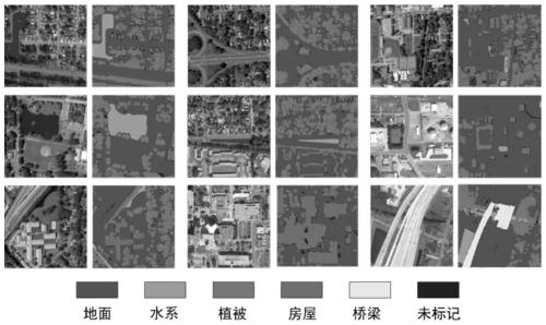
[0050] (1) Using the public data fusion competition track-a high-spatial-resolution remote sensing imagery land cover classification dataset (DFCTrack1), the DFCTrack1 training dataset contains 2783 WorldView-3 images with a size of 1024×1024 pixels. The dataset contains five land cover categories: ground, tall vegetation, building roofs, water, and bridges, and its visualization is shown in Figure 1.

[0051] 1.1. Since the public dataset already has labels, the training set TrainA and TrainB are directly divided by 1:1.

[0052] 1.2. Use ...


PUM


Abstract

The invention relates to a high-resolution remote sensing image land cover classification method based on depth architecture automatic search. The method is used for automatically searching a convolutional neural network architecture suitable for a specific data set. According to the method, a deep learning theory is combined, a hierarchical search space and a cascade training strategy are designed, a convolutional neural network design is converted into a data-based driving mode, and a series of lightweight operations are constructed as candidates, so that the efficiency of searching a network architecture is ensured. The framework adapts to a network architecture through the cavity pyramid pooling module, so that the framework is suitable for a high-resolution remote sensing image recognition task. According to the method, the problems of high professional knowledge and time cost requirements and the like of an existing artificial design architecture can be solved, a proper deep learning model is automatically searched for a specific high-resolution remote sensing image land cover classification data set, and the model design efficiency and precision can be effectively improved.

Description

technical field [0001] The invention belongs to the field of high-resolution remote sensing image recognition, in particular to a method for land cover classification of high-resolution remote sensing images based on automatic search of a depth framework. Background technique [0002] With the rapid development of remote sensing technology, a large number of high-resolution remote sensing images can now be provided. Compared with low-resolution images, high-resolution remote sensing images contain more detailed spatial information, which not only brings opportunities, but also poses challenges to the classification of remote sensing images. Classification and analysis based on high-resolution remote sensing imagery technology has been applied to land cover classification tasks. [0003] The task of land cover classification has long been a daunting task in remote sensing. Conventional methods rely only on low-level spectral and spatial features, such as histograms of orien...

Claims


Application Information

Patent Timeline
Patent Type & Authority Applications(China)
IPC IPC(8): G06K9/00G06K9/62G06N3/04G06N3/08G06T3/40
CPCG06N3/084G06T3/4053G06T2207/10032G06T2207/30181G06T2207/20081G06T2207/20084G06V20/13G06N3/045G06F18/241
Inventor 钟燕飞王俊珏马爱龙郑卓
Owner WUHAN UNIV
Why Eureka
Try Eureka