Positioning and navigation method based on spatial information model and real-time image comparison

A space information, positioning and navigation technology, applied in the field of positioning and navigation, can solve problems such as noise interference, wrong navigation direction, signal offset, etc., and achieve the effect of three-dimensional navigation, high positioning accuracy and low construction cost

Active Publication Date: 2020-05-22
POWERCHINA HUADONG ENG COPORATION LTD
View PDF21 Cites 5 Cited by
  • Summary
  • Abstract
  • Description
  • Claims
  • Application Information

AI Technical Summary

Problems solved by technology

Outdoor positioning and navigation maps, such as AutoNavi and Baidu, etc. With the accumulation of user groups and closely following the development and changes of cities, the map content is constantly updated, but the precise positioning is subject to the characteristics of navigation and positioning technology, which is prone to signal deviation and noise interference , the navigation direction is wrong, etc.
Indoor positioning and navigation is currently mainly used in hospitals, comprehensive shopping malls, large venues, etc. Indoor maps are built separately and resources are not shared with each other. There is currently no public version of indoor map services

Method used


Image

  • Positioning and navigation method based on spatial information model and real-time image comparison
  • Positioning and navigation method based on spatial information model and real-time image comparison
  • Positioning and navigation method based on spatial information model and real-time image comparison

Examples


specific Embodiment

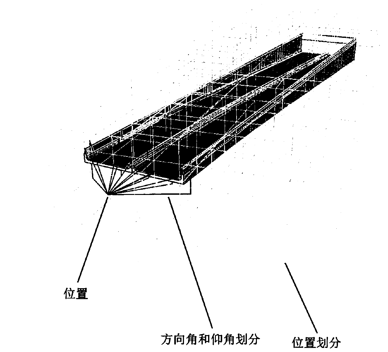
[0032] To optimize the above scheme, in step S1, theoretically, the spatial information model can be subdivided infinitely. In practice, it will be within the range of possible positions and viewing angles of moving objects according to the significance of spatial features, the constraints of positioning and navigation, and the accuracy requirements. perform finite-precision meshing (e.g. figure 2 shown), reduce the number of records in the location information table, and speed up the extraction of effective information.

[0033] To optimize the above scheme, in step S1, the spatial information model is a three-dimensional visualization model produced synchronously in the computer when the project is renovated or newly built, covering the indoor model and the outdoor model, and is the digital handover information of the project completed by the construction party. The model image features are extracted from the long-term stable features of the terrain, civil structures, mecha...


PUM


Abstract

The invention provides a positioning and navigation method based on a spatial information model and real-time image comparison. The method comprises the following steps of: performing full-space and all-around mesh generation on a spatial information model, extracting model image features of all nodes and viewing angles, and recording the model image features into a position information table; andthen acquiring a live-action image of a moving object at a current position and viewing angle, performing live-action image feature extraction, and performing matching retrieval on the extracted image features and the position information table to obtain the current position and viewing angle information of the moving object. A complex indoor building can be positioned and navigated by using thespatial information model provided by engineering construction completion, the positioning precision is higher, the construction cost is low, and the navigation is more three-dimensional and intuitive. The situation that indoor and outdoor positioning and navigation technologies are isolated from each other is broken, and integrated application of indoor and outdoor positioning and navigation is achieved by unifying data sources and unifying technologies.

Description

technical field [0001] The invention relates to the technical field of positioning and navigation, in particular to a positioning and navigation method based on comparison between a spatial information model and a real-time image. Background technique [0002] With the rapid development of satellite navigation technologies such as GPS and Beidou, as well as mobile devices and wireless communication technologies, it has brought great convenience to public travel, and solved the needs of indoor and outdoor positioning and navigation to a certain extent, but indoor and outdoor navigation are isolated from each other. , has not yet formed a positioning and navigation solution for indoor and outdoor integrated applications. Outdoor positioning and navigation maps, such as AutoNavi and Baidu, etc. With the accumulation of user groups and closely following the development and changes of cities, the map content is constantly updated, but the precise positioning is subject to the cha...

Claims


Application Information

Patent Timeline
Patent Type & Authority Applications(China)
IPC IPC(8): G01C21/00
CPCG01C21/005
Inventor 王国光赵杏英徐震陈沉
Owner POWERCHINA HUADONG ENG COPORATION LTD
Why Eureka
Try Eureka