Pipeline geographic position information measurement method based on thick-tail robust filtering

A geographical location information, thick tail robust technology, applied in the direction of measuring device, navigation through speed/acceleration measurement, surveying and navigation, etc., can solve the problems of modeling error, reduce the measurement accuracy of pipeline location information, etc.

Active Publication Date: 2020-05-29
HARBIN ENG UNIV
View PDF8 Cites 5 Cited by
  • Summary
  • Abstract
  • Description
  • Claims
  • Application Information

AI Technical Summary

Problems solved by technology

However, the traditional Kalman filter algorithm often assumes Gaussian white noise for the processing of system noise and measurement noise, which has obvious modeling errors with the thick-tailed noise in the actual system, thereby reducing the measurement accuracy of pipeline geographic location information

Method used


Image

  • Pipeline geographic position information measurement method based on thick-tail robust filtering
  • Pipeline geographic position information measurement method based on thick-tail robust filtering
  • Pipeline geographic position information measurement method based on thick-tail robust filtering

Examples


Embodiment Construction

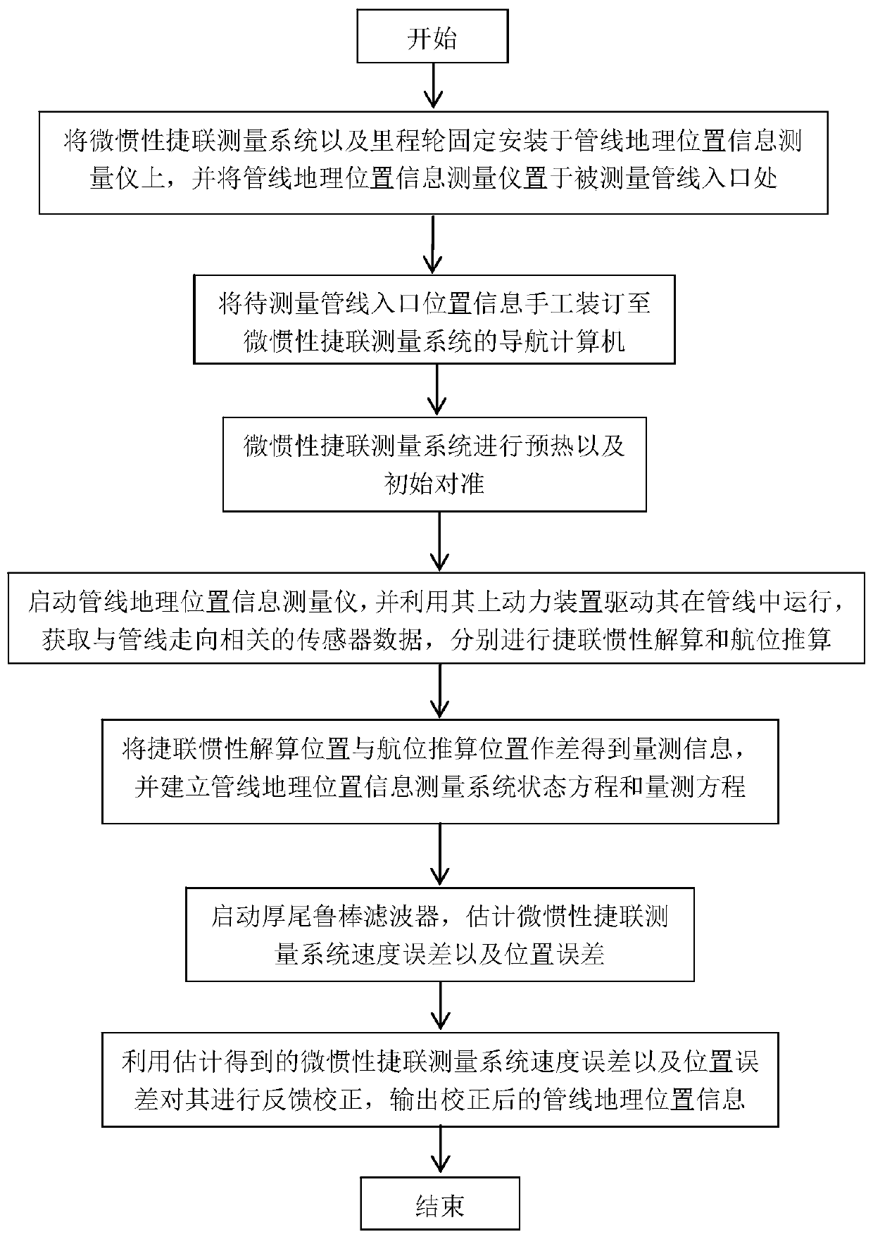
[0095] The specific embodiments of the present invention will be further described below in conjunction with the accompanying drawings.

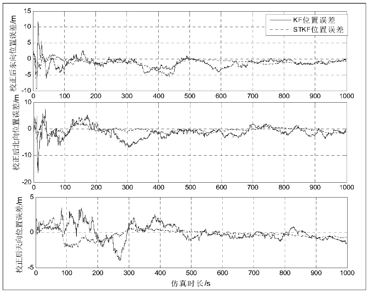
[0096] The present invention drives it to run in the pipeline through the system power device to acquire sensor data related to the direction of the pipeline, and performs strapdown inertial calculation and dead reckoning respectively; uses the difference between the strapdown inertial calculation position and dead reckoning position as the quantity The outlier information of the position measurement caused by the mileage wheel slipping, sliding fault and failure of the pipeline motion constraint conditions is filtered by the thick-tailed robust filter, and the strapdown inertia solution error is estimated and the pipeline geographic location information is corrected at the same time. output.

[0097] Attached below figure 1 The present invention will be described in more detail with examples. A method for measuring geographic location inf...


PUM


Abstract

The invention discloses a pipeline geographic position information measurement method based on thick-tail robust filtering and relates to the technology of pipeline geographic position information measurement. The method is characterized in that an inertia / odometer wheel combined positioning system is composed of an MSINS and an odometer wheel, the inertia / odometer wheel combined positioning system is driven by a system power device to operate in a pipeline to obtain sensor data related to the trend of a pipeline, and strapdown inertia calculation and dead reckoning are conducted respectively,a difference value between the strapdown inertial calculation position and the dead reckoning position is used as the measurement information, the position measurement outlier information caused by odometer wheel slipping, sliding faults and pipeline motion constraint condition failure is filtered out through a thick-tail robust filter, moreover, strapdown inertia calculation errors are estimated, pipeline geographic position information output is corrected, and thereby a system can provide the continuous and high-precision pipeline geographic position information.

Description

technical field [0001] The invention relates to a method for measuring geographical position information of pipelines, in particular to a method for measuring geographical position information of pipelines based on thick-tail robust filtering. Background technique [0002] Underground pipelines are an important part of urban infrastructure. Pipelines such as water supply, drainage, gas, and heat supply transport materials and energy for people's daily life, and are the lifeline to ensure the normal and orderly life of the city. However, with the increase of pipeline operation time and the change of local geological structure, various environmental factors such as settlement and frost heave will easily lead to displacement and deformation of in-service pipelines, which will cause large bending strains in local pipe bodies, and lead to pipeline instability in severe cases Pipeline failure problems such as material damage or material damage, so that the structural integrity and...

Claims


Application Information

Patent Timeline
Patent Type & Authority Applications(China)
IPC IPC(8): G01C21/18G01C21/16
CPCG01C21/18G01C21/165
Inventor 李倩赵显鹏奔粤阳赵玉新陈立恒吴磊王洪星戴平安
Owner HARBIN ENG UNIV
Why Eureka
Try Eureka