Spatial geographic information big data processing system

A technology of big data processing and geographic information, applied in the field of spatial geographic information, which can solve the problems of low efficiency, different data time, space and scale, and high resource consumption.

Pending Publication Date: 2020-05-29
安徽美图信息科技有限公司
View PDF1 Cites 3 Cited by
  • Summary
  • Abstract
  • Description
  • Claims
  • Application Information

AI Technical Summary

Problems solved by technology

[0005] Due to different industries, different directions, different spaces, etc., there are many types of spatial geographic information data, and the time, space and scale of the data are different, and the application requirements are different. Therefore, the processing of spatial geographic information data needs to be done separately, and the resource consumption is large. , less efficient

Method used


Image

  • Spatial geographic information big data processing system
  • Spatial geographic information big data processing system

Examples


Embodiment Construction

[0048] In order to make the purpose, technical solutions and advantages of the embodiments of the present invention more clear, the technical solutions in the embodiments of the present invention will be clearly and completely described below in conjunction with the accompanying drawings in the embodiments of the present invention. Obviously, the described embodiments It is a part of embodiments of the present invention, but not all embodiments. Based on the embodiments of the present invention, all other embodiments obtained by persons of ordinary skill in the art without making creative efforts belong to the protection scope of the present invention.

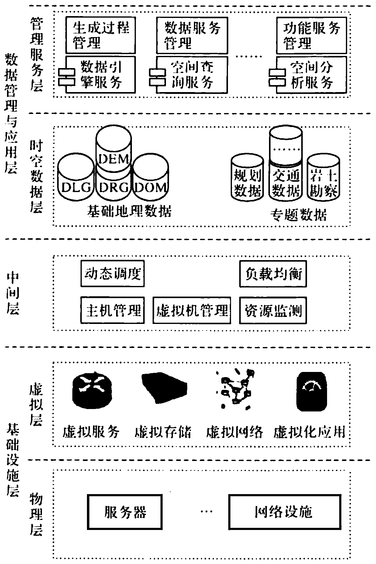
[0049] The present invention provides a spatial geographic information big data processing system, exemplary, figure 1 shows a schematic diagram of a logical structure of an embodiment of the present invention, such as figure 1 As shown, the processing system includes a data management and application layer, an intermediate l...


PUM


Abstract

The invention discloses a spatial geographic information big data processing system, which comprises a data management and application layer, an intermediate layer and an infrastructure layer, and ischaracterized in that the data management and application layer is used for carrying out classification and grading processing on data information and providing the processed data information to the outside; the intermediate layer is used for dynamically monitoring data interaction calling in the data management and application layer and recording a process; and the infrastructure layer is used for providing software and hardware support for the data management and application layer and the intermediate layer. According to the invention, spatial geographic information data is collected, managed and processed; by utilizing a cloud computing technology, a spatial analysis technology, a model analysis technology, a network technology, a database integration technology and the like and utilizing a big data analysis method, diversified and distinctive application of spatial geographic information is realized, and personalized application requirements of different industries and different directions on the spatial geographic information are met.

Description

technical field [0001] The invention belongs to the technical field of spatial geographic information, and in particular relates to a large data processing system of spatial geographic information. Background technique [0002] Spatial geographic information is geographic information data obtained through various means, including natural geographic data, land cover type data, landform data, soil data, hydrological data, vegetation data, residential data, river data, administrative realm and socioeconomic data, etc. In many aspects, its biggest feature is the large volume of data. [0003] Spatial geographic information mainly has three data types, one is surveying and mapping data, such as images, electronic maps, etc.; the other is various discrete data streams, such as various trajectory data generated by positioning terminals such as street view collection vehicles; the third is location-related pictures. , video, voice and other unstructured data. [0004] Spatial geog...

Claims


Application Information

Patent Timeline
Patent Type & Authority Applications(China)
IPC IPC(8): G06F16/25G06F16/27G06F16/29
CPCG06F16/252G06F16/27G06F16/29
Inventor 卢广师
Owner 安徽美图信息科技有限公司
Why Eureka
Try Eureka