High-precision direction arrow extraction method and system based on point cloud

A high-precision, arrow technology, which is applied in image data processing, instruments, character and pattern recognition, etc., can solve the problem of low extraction efficiency of direction arrows, achieve the effect of saving time and economic cost, high precision, and improving extraction efficiency

Active Publication Date: 2020-05-29
WUHAN ZHONGHAITING DATA TECH CO LTD
View PDF3 Cites 0 Cited by
  • Summary
  • Abstract
  • Description
  • Claims
  • Application Information

AI Technical Summary

Problems solved by technology

[0004] Aiming at the technical problems existing in the prior art, the present invention provides a method for extracting high-precision direction arrows based on point clouds, which solves the problem of extraction efficiency of direction arrows in the prior art low problem

Method used


Image

  • High-precision direction arrow extraction method and system based on point cloud
  • High-precision direction arrow extraction method and system based on point cloud
  • High-precision direction arrow extraction method and system based on point cloud

Examples


Embodiment 1

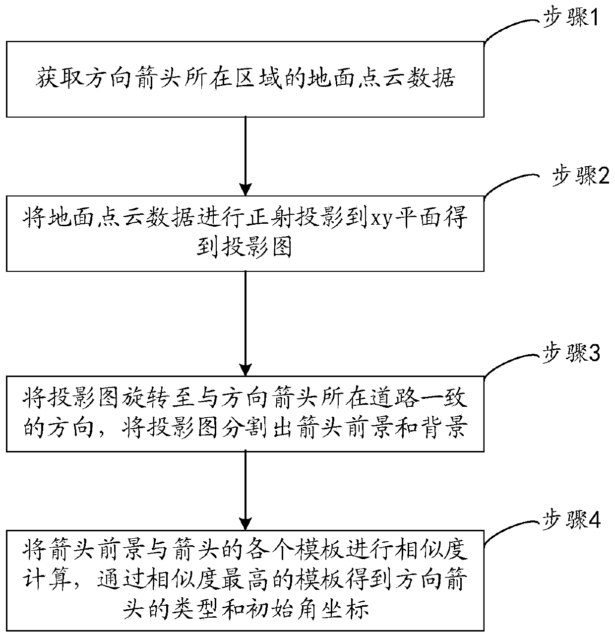
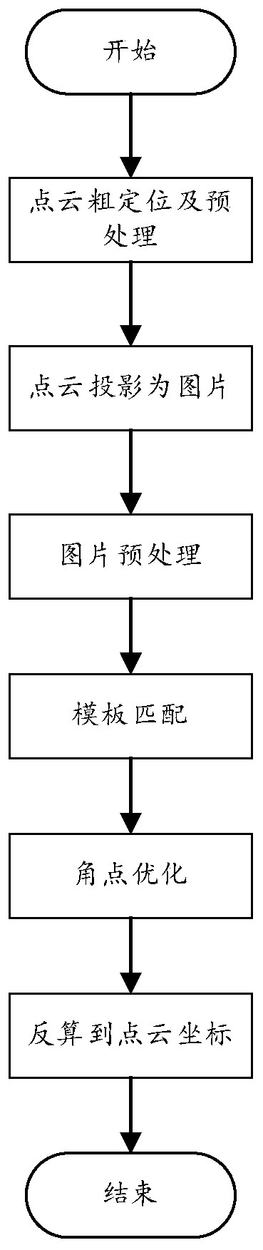
[0046] Embodiment 1 provided by the present invention is an embodiment of a method for extracting high-precision direction arrows based on point clouds provided by the present invention, such as figure 2 Shown is a flow chart of an embodiment of a point cloud-based high-precision direction arrow extraction method provided by the present invention. Depend on figure 2 It can be seen that the method includes:

[0047] Step 1. Obtain the ground point cloud data of the area where the direction arrow is located.

[0048] The positioning point of the direction arrow is determined by manual selection or calculation of road video or picture data, and the location is determined according to the positioning point and the size of the area, and the size of the area is set according to the actual situation of the road.

[0049] In step 1, perform rough positioning on the position of the direction arrow. You only need to ensure that the ground point cloud data completely contains the dir...

Embodiment 2

[0071] Embodiment 2 provided by the present invention is an embodiment of a point cloud-based high-precision direction arrow extraction system provided by the present invention, such as Figure 6 Shown is a structural block diagram of an embodiment of an environmental event monitoring system of the environmental Internet of Things provided by the present invention, consisting of Figure 6 It can be seen that the system includes: a point cloud data acquisition module 101 , a projection map determination module 102 , an arrow foreground determination module 103 and a direction arrow determination module 104 .

[0072] The point cloud data acquisition module 101 acquires the ground point cloud data of the area where the direction arrow is located.

[0073] The projection map determination module 102 performs orthographic projection of the ground point cloud data onto the xy plane to obtain a projection map.

[0074] The arrow foreground determining module 103 is configured to ro...


PUM


Abstract

The invention relates to a high-precision direction arrow extraction method based on point cloud. The method comprises the steps of obtaining ground point cloud data of an area where a direction arrowis located; orthographically projecting the ground point cloud data to an xy plane to obtain a projection drawing; rotating the projection drawing to a direction consistent with the road where the direction arrow is located, and segmenting the projection drawing into an arrow foreground and a background; and performing similarity calculation on the arrow foreground and each template of the arrow,and obtaining the type and initial angular coordinates of the direction arrow through the template with the highest similarity. Compared with manual drawing on the point cloud, the method has the advantages that the extraction efficiency of the arrow elements can be greatly improved, and the precision is high; compared with a deep learning extraction method, the method does not need to mark a large number of pictures, saves time and economic cost, and can be used as a supplement for missing detection of a deep learning extraction result. And the road surface direction arrow attribute data canbe automatically extracted with high efficiency and low consumption.

Description

technical field [0001] The invention relates to the field of high-precision map production and generation, in particular to a method and system for extracting high-precision direction arrows based on point clouds. Background technique [0002] In the field of automatic driving, high-precision map data can be used as a comparison standard for automatic driving, or as a supplement when some perception of automatic driving is lacking, which is of great significance for the development of automatic driving functions. Therefore, many map service companies are producing high-precision digital maps. [0003] When making a high-precision digital map, the direction arrow on the road is a very important ground element, and all companies will include the direction arrow in the digital map. Currently, there are mainly two methods used, one is in the map making Manually draw the shape of the direction arrow and add attributes on the platform. This method can ensure that the accuracy of ...

Claims


Application Information

Patent Timeline
Patent Type & Authority Applications(China)
IPC IPC(8): G06T7/194G06T7/136G06K9/62
CPCG06T7/194G06T7/136G06T2207/10028G06T2207/20164G06T2207/20104G06F18/22
Inventor 陈操肖圣何豪杰何云文铁谋刘奋
Owner WUHAN ZHONGHAITING DATA TECH CO LTD
Why Eureka
Try Eureka