Urban green space information extraction method based on decision tree classification

A decision tree classification and green space technology is applied in the field of urban green space extraction based on decision tree classification.

Pending Publication Date: 2020-06-02
NANJING FORESTRY UNIV
View PDF4 Cites 5 Cited by
  • Summary
  • Abstract
  • Description
  • Claims
  • Application Information

AI Technical Summary

Problems solved by technology

However, because the remote sensing image itself is affected by many factors such as spatial resolution, training sample noise, cloud cover, same object with different spectrum, and same spectrum with different objects, the classification results obtained by using the maximum likelihood method often cannot meet the requirements.

Method used


Image

  • Urban green space information extraction method based on decision tree classification
  • Urban green space information extraction method based on decision tree classification
  • Urban green space information extraction method based on decision tree classification

Examples


Embodiment Construction

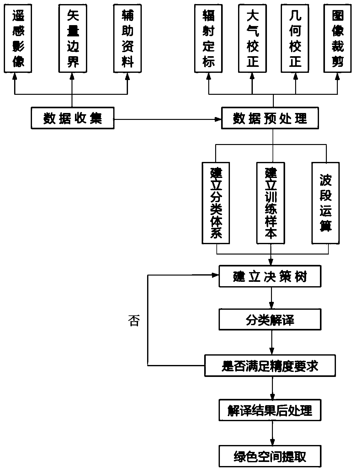
[0043] The following is based on Figure 1 to Figure 4 The specific embodiment of the present invention is further described:

[0044] This embodiment provides a method for extracting urban green space information based on decision tree classification, including the following steps.

[0045] Step (1): Select the scope and time of the study area.

[0046] Step (2): Obtaining remote sensing image data: In step (2), in order to achieve a relatively uniform coverage state and land use state during data acquisition, and to facilitate identification and extraction of green spaces, remote sensing images from May to October were selected and cloud cover was controlled. Below 5%. The type of data acquisition in step (2) of this embodiment is Landsat8 OIL, the specific time is October 5, 2017, and the stripe numbers and row and column numbers are 120 and 38, respectively.

[0047] Step (3): Preprocessing the remote sensing image data.

[0048] Described step (3) is specifically:
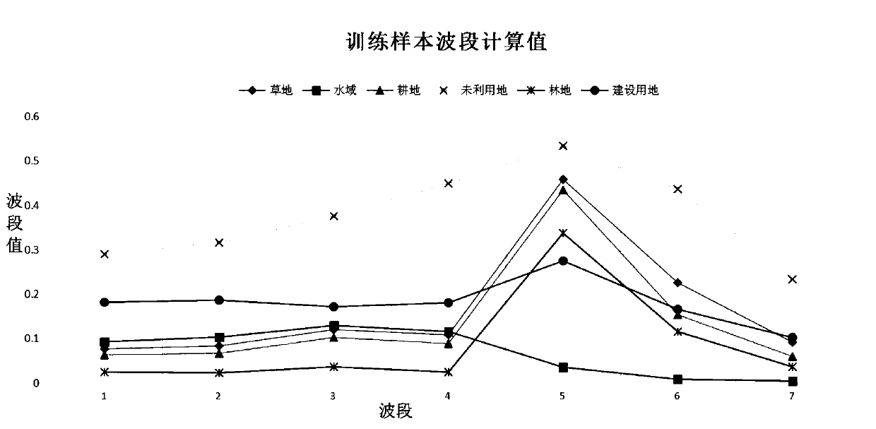
...


PUM


Abstract

The invention discloses an urban green space information extraction method based on decision tree classification. The method comprises the following steps: selecting a research area range; acquiring remote sensing image data; preprocessing the remote sensing image data; dividing land types of the land; selecting a training sample; performing waveband calculation on the remote sensing image data togenerate waveband-calculated remote sensing image data, and obtaining waveband calculation values of various land types according to the training samples; establishing a decision tree classificationrule by referring to the waveband calculation value of each land type, and classifying the remote sensing image data after waveband calculation is completed; vectorizing a classification result; and extracting green space information. Wave band characteristics are obtained through image wave band operation and training sample wave band operation, decision tree classification rules are establishedaccording to the wave band characteristics of training samples, and high-precision classification is achieved; preprocessing errors can be suppressed to a certain extent, noise interference is reduced, the calculation efficiency is high, and the classification precision is improved.

Description

technical field [0001] The invention relates to the technical field of ecological protection, in particular to a method for extracting urban green spaces based on decision tree classification. Background technique [0002] The rapid urbanization process has continuously intensified the evolution of urban land use types, and the continuous increase of construction land has caused the encroachment and destruction of ecological resources, which has brought obstacles and challenges to the sustainable development of the natural environment. Urban green space is a general term for all areas where vegetation grows in urban areas, including mountains, hills, water bodies, wilderness and other spaces covered by artificial vegetation and natural vegetation. The space also includes spaces such as woodlands, farmlands, and river systems in the suburbs of cities. As an important part of land use, urban green space plays an indispensable role in maintaining the sustainable use of land re...

Claims


Application Information

Patent Timeline
Patent Type & Authority Applications(China)
IPC IPC(8): G06K9/62G06F16/29G06Q50/26
CPCG06F16/29G06Q50/26G06F18/24323
Inventor 李欢欣许浩
Owner NANJING FORESTRY UNIV
Why Eureka
Try Eureka