Method for establishing full-space-oriented data model

A data model and full-space technology, applied in the field of artificial intelligence, can solve problems such as discourse, non-multi-granularity spatiotemporal data organization, etc., and achieve the effect of stable data transmission

Inactive Publication Date: 2020-07-03
QINGDAO UNIV
View PDF7 Cites 13 Cited by
  • Summary
  • Abstract
  • Description
  • Claims
  • Application Information

AI Technical Summary

Problems solved by technology

[0006] It can be seen from the research status at home and abroad that whether it is the research on the spatial database itself or the interdisciplinary research on the spatial database and other disciplines,

Method used


Image

  • Method for establishing full-space-oriented data model
  • Method for establishing full-space-oriented data model
  • Method for establishing full-space-oriented data model

Examples


Embodiment Construction

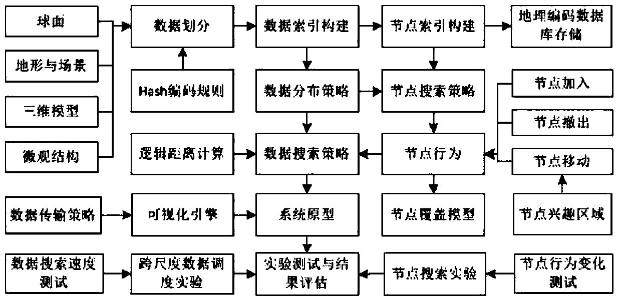
[0108] In order to make the object, technical solution and advantages of the present invention clearer, the present invention will be further described in detail below with reference to the accompanying drawings and examples.

[0109] Such as figure 1 As shown, a method for establishing a data model oriented to the whole space based on Hash geocoding includes the following steps:

[0110] S1, P2P protocol file scheduling based on Hash plaintext geocoding index, generating Hash-based geocoding for indexing nodes and files respectively.

[0111] The sub-steps of S1 are as follows:

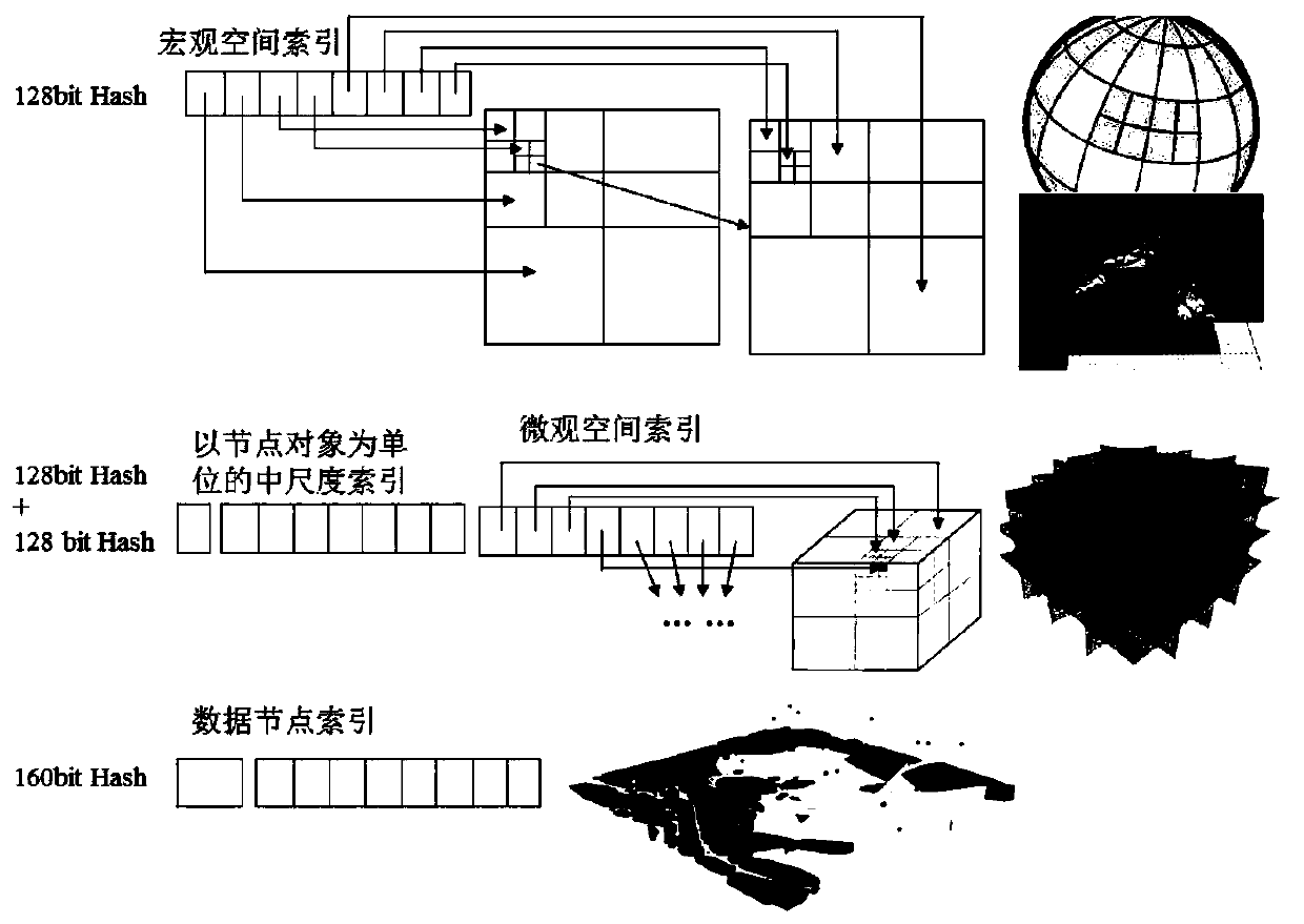
[0112] S11: establish rules based on geographically related Hash plaintext geocoding database;

[0113] The raw data required include vector, elevation, image, 3D mesh, 3D model texture, and protein structure data. On the macroscopic earth scale, vector data, elevation and image data are divided into multi-scale spaces. Each scale level is stored in 4-bit binary Hash plaintext. After n times of di...


PUM


Abstract

The invention discloses a method for establishing a full-space-oriented data model based on Hash geocoding, which comprises the following steps of: S1, scheduling P2P protocol files based on Hash plaintext geocoding indexes, and respectively generating Hash-based geocoding for nodes and files for indexing; s2, establishing a data node network based on a Hash geocoding index; s3, building and evaluating a global virtual environment data sharing prototype and an experimental platform; s4, making a multi-granularity coding rule; s5, spatial object big data storage based on Hash geocoding is carried out; s6, designing NoSQL database. The method has the advantages that support is provided for establishment of a multi-granularity space-time database or a full-space information system; and unification of relative positions between the data storage environment and objects in the real world is realized.

Description

technical field [0001] The invention relates to the technical field of artificial intelligence, in particular to a method for establishing a data model oriented to the whole space based on Hash geocoding. Background technique [0002] As we all know, a major change in today's society is the advent of the era of artificial intelligence. The artificial intelligence industry has ushered in a golden period of development. In the era of artificial intelligence, the lifestyle of the whole society has undergone tremendous changes. People's work, entertainment, shopping, socializing, learning and medical care are increasingly dependent on the Internet and artificial intelligence technology. A key technology in the application of artificial intelligence is the structural division and indexing of spatial data. [0003] The research on the macro-spatial index in the world has been very rich, such as research on subdivision and coding mechanisms such as Spatial Keys and QuadTiles. Ma...

Claims


Application Information

Patent Timeline
IPC IPC(8): G06F16/22G06F16/29G06F16/26G06T17/00
CPCG06F16/2228G06F16/29G06F16/26G06T17/00
Inventor 吕智涵
Owner QINGDAO UNIV
Why Eureka
Try Eureka