Ground camera and sky mobile unmanned aerial vehicle linkage analysis method and system

An analysis system and camera technology, applied in the transmission system, closed-circuit television system, TV system components, etc., can solve the problems of information waste, limited shooting information, and full scene coverage, so as to improve storage efficiency, improve efficiency, The effect of improving data storage efficiency

Inactive Publication Date: 2020-07-10
北京大学(天津滨海)新一代信息技术研究院
View PDF5 Cites 5 Cited by
  • Summary
  • Abstract
  • Description
  • Claims
  • Application Information

AI Technical Summary

Problems solved by technology

Highly dense cameras cannot provide full scene coverage
Although the distribution density of cameras in some areas is very high, it is still impossible to cover the whole scene, and the information captured by ground cameras in the areas covered by cameras is also limited. valuable information, resulting in a huge waste of information

Method used


Image

  • Ground camera and sky mobile unmanned aerial vehicle linkage analysis method and system
  • Ground camera and sky mobile unmanned aerial vehicle linkage analysis method and system
  • Ground camera and sky mobile unmanned aerial vehicle linkage analysis method and system

Examples


Embodiment 1

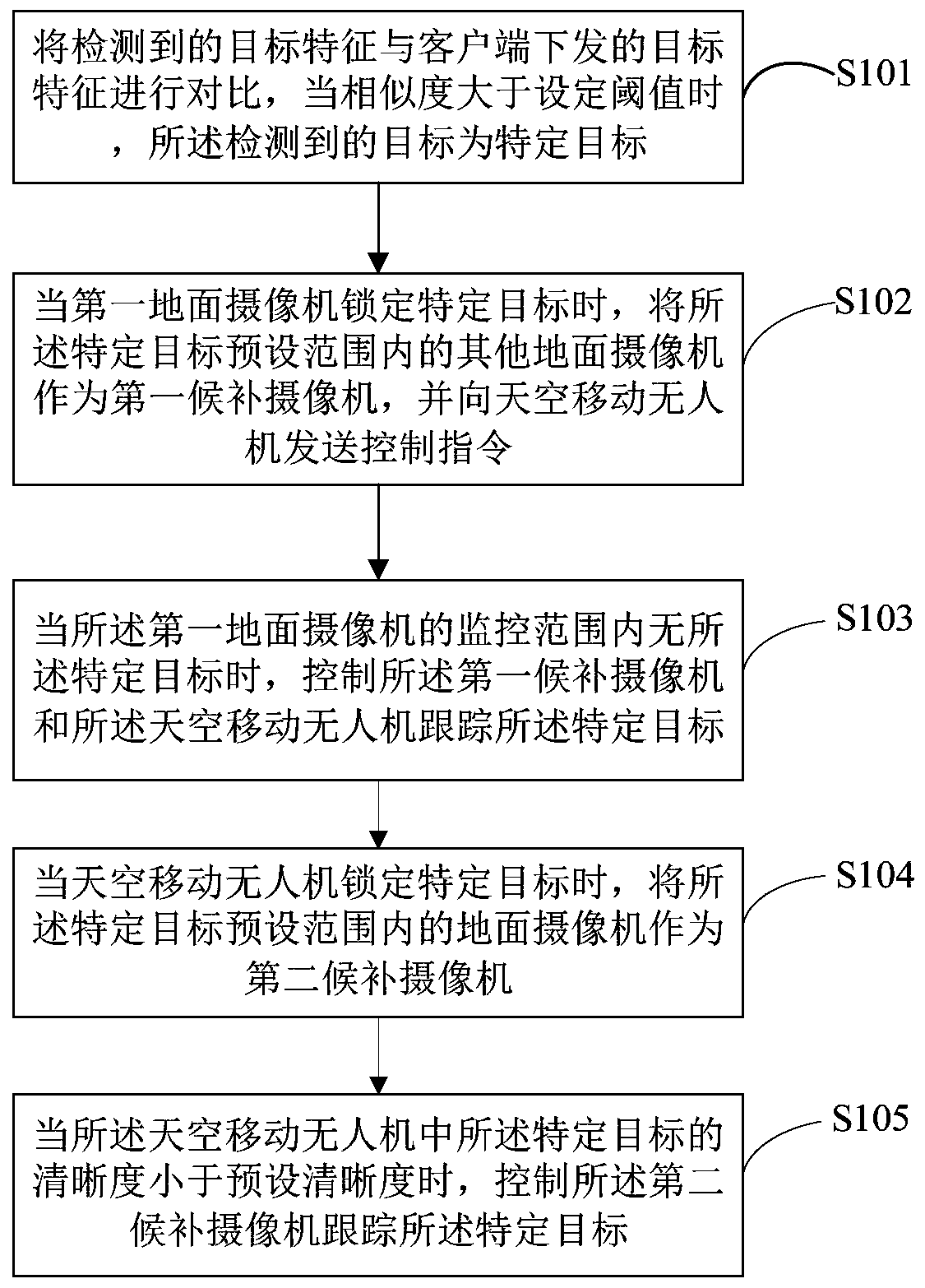
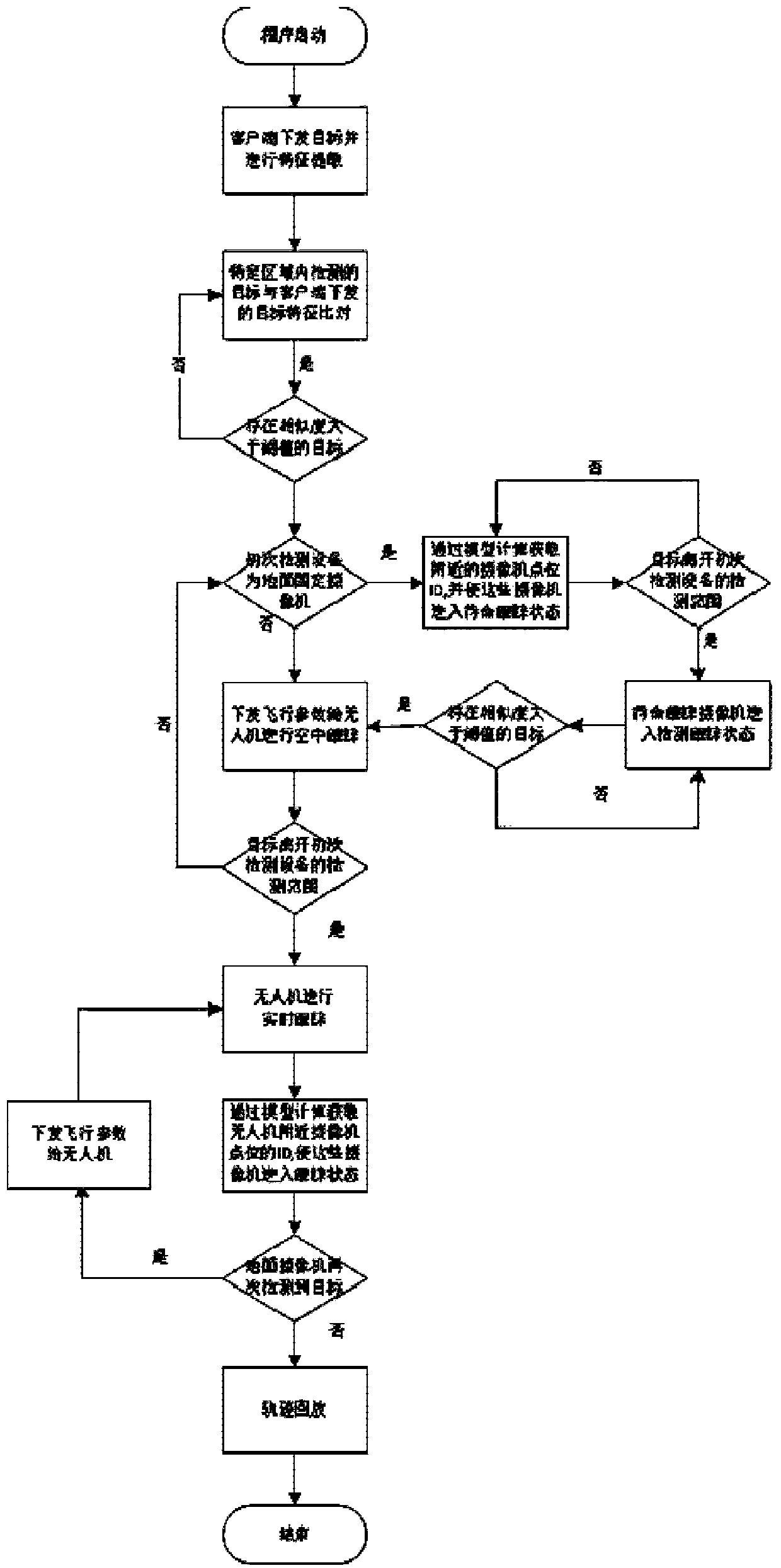
[0055] An embodiment of the present disclosure provides a linkage analysis method for a ground camera and a mobile UAV in the sky. figure 1 It is a schematic flowchart of a method for analyzing the linkage between a ground camera and a mobile UAV in the sky according to an exemplary embodiment;

[0056] Such as figure 1 As shown, a ground camera and sky mobile UAV linkage analysis method, including:

[0057] S101. Compare the detected target features with the target features delivered by the client, and when the similarity is greater than a set threshold, the detected target is a specific target;

[0058] Among them, the specific target is the target sent by the client according to the actual monitoring task. In the embodiment of the present disclosure, the target sent by the client is first obtained, and the feature information of the target image sent by the client is extracted according to the preset model. The linkage analysis system with the mobile UAV in the sky respon...

Embodiment 2

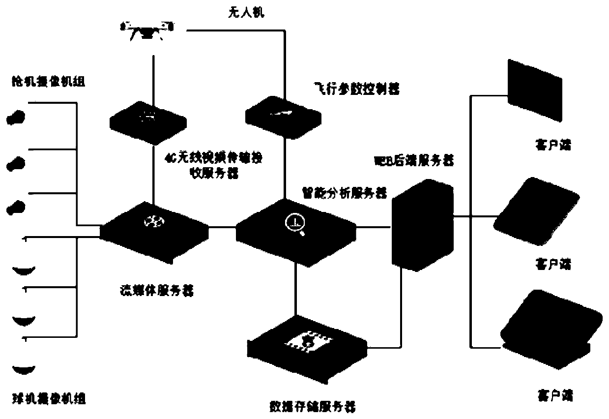
[0095] An embodiment of the present disclosure provides a linkage analysis system for a ground camera and a mobile UAV in the sky. image 3 It is a structural schematic diagram of a linkage analysis system for a ground camera and a mobile UAV in the sky according to an exemplary embodiment.

[0096] Such as image 3 As shown, a linkage analysis system for a ground camera and a mobile UAV in the sky, including:

[0097] The ground camera is used to obtain image information and send the image information to the streaming media server;

[0098] In some exemplary scenarios, the ground camera is two or more cameras. The ground camera includes a bolt camera and a dome camera. , Bolt cameras are suitable for the monitoring of target moving scenes, such as road monitoring. In the disclosed embodiment of the present invention, it is composed of multiple bolts and ball cameras, and the multiple bolts and ball cameras are linked in real time to send the acquired image information to t...


PUM


Abstract

The invention discloses a ground camera and sky mobile unmanned aerial vehicle linkage analysis method, which comprises the steps of comparing a detected target feature with a target feature issued bya client, and when the similarity is greater than a set threshold, determining that the detected target is a specific target; when the first ground camera locks the specific target, taking other ground cameras in a preset range of the specific target as first candidate cameras, and sending a control instruction to the sky mobile unmanned aerial vehicle; when no specific target exists in the monitoring range of the first ground camera, controlling the first candidate camera and the sky moving unmanned aerial vehicle to track the specific target; when the sky moving unmanned aerial vehicle locks the specific target, taking a ground camera in a preset range of the specific target as a second candidate camera; and when the definition of the specific target in the sky moving unmanned aerial vehicle is smaller than the preset definition, controlling the second candidate camera to track the specific target. Through the method, multi-camera tracking is realized for the target according to a space-time association automatic switching mode.

Description

technical field [0001] The invention relates to the technical field of video surveillance, in particular to a method and system for linkage analysis of a ground camera and a mobile UAV in the sky. Background technique [0002] With the rapid development of science and technology, the video surveillance system composed of camera network has become an important guarantee for protecting public safety and maintaining social stability. [0003] In the current prior art, obtaining a large amount of information data through a camera is also facing challenges. Highly dense cameras cannot provide full scene coverage. Although the distribution density of cameras in some areas is very high, it is still impossible to cover the whole scene, and the information captured by ground cameras in the areas covered by cameras is also limited. value information, resulting in a huge waste of information. [0004] Therefore, it is of great practical significance to establish a cooperative tracki...

Claims


Application Information

Patent Timeline
Patent Type & Authority Applications(China)
IPC IPC(8): H04N7/18H04N5/232H04L29/08G06K9/00
CPCH04N7/181H04L67/025H04L67/1097H04L67/12G06V20/13H04N23/661H04N23/695
Inventor 任立鹏钱方正汪涛贾惠柱杨长水齐峰
Owner 北京大学(天津滨海)新一代信息技术研究院
Why Eureka
Try Eureka