Road fine design method

A design method and road technology, applied in the direction of calculation, instrumentation, geometric CAD, etc., can solve problems such as inaccurate calculation of engineering quantities, many sources of danger in the construction environment, and large differences in elevation, so as to reduce the intensity of manpower work and improve the ability to prevent , The effect of reducing the project cost

Pending Publication Date: 2020-07-17
CCCC SECOND HARBOR ENG
View PDF3 Cites 10 Cited by
  • Summary
  • Abstract
  • Description
  • Claims
  • Application Information

AI Technical Summary

Problems solved by technology

In the conventional two-dimensional design process, these three-dimensional images are converted into two-dimensional graphics such as plane points and contour lines for storage and representation, which will lead to inaccurate information expression and communication
Especially at present, the construction of construction access roads at home and abroad is extremely random, and there are no relevant design and construction specifications. Random excavation, random filling, random construction, and environmental damage are common, resulting in construction access roads in terms of safety, environmental protection and cost control. Seriously insufficient
At the same time, the traditional road planning adopts the method of on-site line selection and point selection, which consumes a lot of manpower and material resources, and the cost is difficult to control. At the same time, it is relatively passive in terms of overall control of the entire survey area.
In addition, in areas with complex terrain, there is a large difference in elevation within a short distance, steep slopes, rapid currents, and intricate terrain, which cause difficulties such as inconvenient transportation, limited sites, and many sources of danger in the construction environment. However, the design of construction access roads at home and abroad is extensive and random. , did not adopt refined design for complex terrain areas, and there were many problems such as rework, damage to the environment, high safety risks, and inaccurate calculation of engineering quantities

Method used


Image

  • Road fine design method
  • Road fine design method
  • Road fine design method

Examples


Embodiment 1

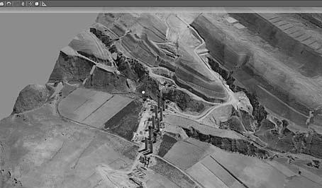
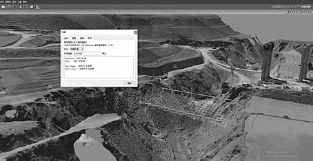
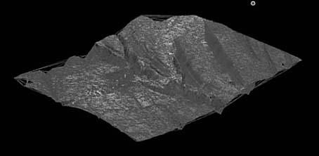
[0058] like Figure 1~13 As shown, a road refinement design method is used to generate a centimeter-level 3D real-scene model of the road by carrying multiple digital cameras on the UAV flying platform at high altitude above the road, and then extract the digital terrain model and import it into the BIM design platform for further analysis. Intuitive analysis of terrain, horizontal and vertical geometric analysis, design of road subgrade and pavement, and comparison and selection of schemes.

[0059] In the preferred scheme, the method for generating the centimeter-level 3D real-scene model is:

[0060] S1. Mount multiple digital cameras on the UAV flight platform;

[0061] S2. Manipulate the UAV flying platform to collect high-resolution images from multiple vertical and oblique angles over the road at the same time;


PUM


Abstract

The invention provides a road fine design method. A plurality of digital cameras are carried on an unmanned aerial vehicle flight platform at high altitude above a road to generate a centimeter-levelthree-dimensional live-action model of the road; then the digital terrain model is extracted and imported into a BIM design platform for terrain visual analysis, horizontal and longitudinal geometricanalysis, road subgrade and pavement design and scheme comparison and selection, the design accuracy is improved, field survey work is reduced, the advantages of intelligence, high flexibility and visualization are achieved, field environment live-action simulation is achieved, and the safety of the design scheme is ensured; the survey efficiency and precision are improved while the labor intensity is reduced; schemes are quantitatively compared and selected, so that the engineering cost is reduced; three-dimensional visual service is provided for shortcut line decision making, accurate simulation is achieved, disordered phenomena such as disordered digging, disordered filling, disordered building and environment damage are avoided, and the method is green, energy-saving and environmentally friendly; the method can be used for road design, and can also be used for construction process monitoring, accurate calculation of engineering quantity change, potential safety hazard investigationand the like.

Description

technical field [0001] The invention relates to the field of civil engineering construction, in particular to a road refinement design method. Background technique [0002] Road engineering projects are different from individual construction projects of the construction site type. They are generally distributed in a belt shape and are closely related to the geology, hydrology, and topography along the line. Measurement data such as terrain and landform features are inherently three-dimensional. In the conventional two-dimensional design process, these three-dimensional images are converted into two-dimensional graphics such as plane points and contour lines for storage and representation, which will lead to inaccurate information expression and communication. Especially at present, the construction of construction access roads at home and abroad is extremely random, and there are no relevant design and construction specifications. Random excavation, random filling, random c...

Claims


Application Information

Patent Timeline
Patent Type & Authority Applications(China)
IPC IPC(8): G06F30/13G06T17/05
CPCG06T17/05G06T2210/04
Inventor 周舒惠迎新胡义新陈成徐小林别亚威周跃亮冯小马
Owner CCCC SECOND HARBOR ENG
Why Eureka
Try Eureka