Unmanned aerial vehicle navigation database sharing system and method

A technology for navigating data and sharing systems, applied in the field of information processing, can solve problems such as difficulties, difficulty in observing the environment with the naked eye, and obstructing the operator's observation, and achieve the effect of improving operating skills

Pending Publication Date: 2020-08-25
HANGXUN INFORMATION TECH CO LTD
View PDF5 Cites 2 Cited by
  • Summary
  • Abstract
  • Description
  • Claims
  • Application Information

AI Technical Summary

Problems solved by technology

[0003] Usually, UAVs fly manually, which requires the operator to pay attention to the flying environment at all times, which is extremely difficult in complex flying environments
After the UAV flies to a certain height and distance, it will be difficult for the operator to observe the environment where the UAV is located with the naked eye, especially after the UAV enters a complex environment, some obstacles will prevent the operator from observing, resulting in some Dangerous Operation or Behavior
[0004] The existing UAV navigation lacks objective navigation data, and it is easy to affect the navigation effect due to environmental factors during human navigation.

Method used


Image

  • Unmanned aerial vehicle navigation database sharing system and method
  • Unmanned aerial vehicle navigation database sharing system and method

Examples


Embodiment 1

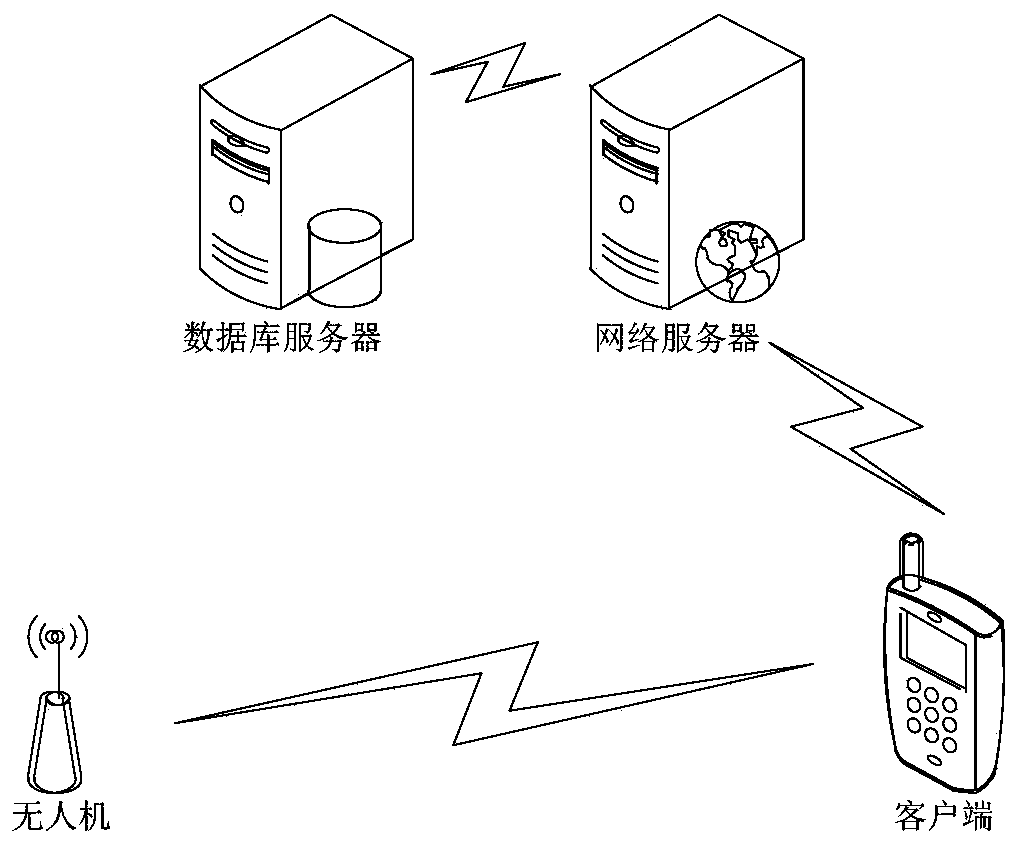
[0041] like figure 1 As shown, a kind of unmanned aerial vehicle navigation database sharing system is disclosed in this embodiment, comprising:

[0042] The server is used to store and analyze data, and process flight data into navigation data files;

[0043] The client communicates with the server, sends flight data to the server, and obtains navigation data files from the server;

[0044] The UAV communicates with the client, sends flight data to the client, and obtains navigation data files from the client.

[0045] The UAV navigation database sharing system disclosed above uses the server as the final carrier of data, stores the UAV flight data uploaded by the user, and saves it in the form of navigation data files; through the client as an intermediary, unmanned After recording the flight data returned by the drone, it is transmitted to the server, and the server makes the navigation data file; at the same time, the client can also obtain the navigation data file from ...

Embodiment 2

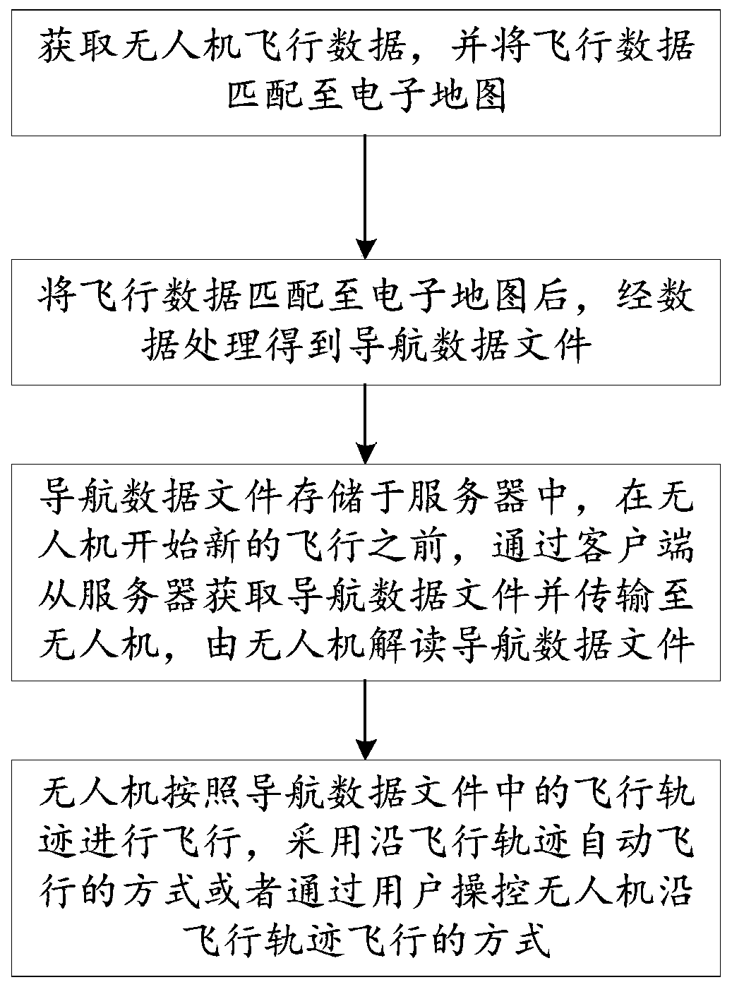
[0054] like figure 2 As shown, this embodiment discloses a method for sharing a navigation database of a UAV. Using the above-mentioned UAV navigation database system, the sharing of the navigation database of a UAV can be realized. details as follows:

[0055] A method for sharing a drone navigation database, comprising:

[0056] Obtain UAV flight data and match the flight data to the electronic map;

[0057] After matching the flight data to the electronic map, the navigation data file is obtained through data processing;

[0058] The navigation data files are stored in the server, and before the UAV starts a new flight, the navigation data files are obtained from the server through the client and transmitted to the UAV, and the UAV interprets the navigation data files;

[0059] The UAV flies according to the flight path in the navigation data file, and adopts the method of automatically flying along the flight path or the method of controlling the UAV to fly along the f...


PUM


Abstract

The invention relates to an information processing technology, belongs to the field of unmanned aerial vehicle navigation, and particularly relates to an unmanned aerial vehicle navigation database sharing system and method. The sharing system comprises a server, a client and an unmanned aerial vehicle, wherein the server serves as a final carrier of data, and stores unmanned aerial vehicle flightdata uploaded by a user in the form of a navigation data file; the client is used as an intermediate medium, records the flight data returned by the unmanned aerial vehicle and then transmits the data to the server, and the server makes the navigation data file; meanwhile, the client can also obtain the navigation data file from the server for flight navigation of the unmanned aerial vehicle. Navigation data are stored in the server and can be downloaded and used by other users, so that sharing of flight data and flight path routes of the unmanned aerial vehicle is achieved efficiently and rapidly, and the method has great significance in safe flight of the unmanned aerial vehicle and improvement of operation skills of the users.

Description

technical field [0001] The invention relates to information processing technology, which is combined with unmanned aerial vehicle technology and applied to the field of unmanned aerial vehicle navigation, in particular to a system and method for sharing an unmanned aerial vehicle navigation database. Background technique [0002] Nowadays, with the rapid development of science and technology, drone technology is changing with each passing day, and various drones used in industry, agriculture, entertainment, military, etc. emerge in endlessly. Because the number of UAVs is increasing day by day, the management of UAV flight routes is particularly important, especially when UAVs fly under complex environmental conditions, whether the routes are reasonable will directly affect the safety of UAVs. [0003] Usually, drones fly manually, which requires the operator to pay attention to the flying environment at all times, which is extremely difficult in complex flying environments....

Claims


Application Information

Patent Timeline
Patent Type & Authority Applications(China)
IPC IPC(8): H04W4/02H04W4/024H04W4/44H04L29/08H04L29/06G07C5/00G07C5/08G06F16/29
CPCH04W4/024H04W4/025H04W4/44H04L67/06H04L67/1095H04L67/1097G07C5/008G07C5/0841G06F16/29H04L67/562H04L67/01
Inventor 庄抒陶伟张云翔
Owner HANGXUN INFORMATION TECH CO LTD
Why Eureka
Try Eureka