
Heading machine positioning method and system based on inertial navigation and laser radar single-point distance measurement

A technology of laser radar and positioning method, which is applied in the direction of radio wave measurement system, navigation, measuring device, etc., can solve the problems of not being able to effectively obtain the direction and attitude of the roadheader, positioning information position information error, and positioning accuracy reduction, etc. The effects of interference positioning, precise positioning and orientation accuracy, and high-precision positioning and orientation

Active Publication Date: 2020-09-08
CENT SOUTH UNIV
View PDF6 Cites 2 Cited by
  • Summary
  • Abstract
  • Description
  • Claims
  • Application Information

AI Technical Summary

Problems solved by technology

[0004] (1) Disadvantages of the autonomous positioning technology of the roadheader based on laser positioning: because this method uses the laser positioning sensor to generate a position signal based on the laser beam received by the laser target to obtain the location of the roadheader, this method can only get the position of the roadheader information, but cannot effectively obtain the direction and attitude of the roadheader traveling in the roadway
[0005] (2) The disadvantages of the autonomous positioning technology of the roadheader based on the inertial navigation system are: because this method uses the inertial navigation system to determine the position information of the carrier in real time, but the inertial navigation system uses the inertial measurement element to measure the acceleration of the carrier and obtain it through integration. The attitude and position information of the carrier, gyro drift and other factors cause errors to accumulate over time, and the roadheader usually needs to work underground for a week or more. Therefore, the position measurement technology based on inertial measurement technology is used for the autonomous positioning and orientation system of the roadheader. Errors accumulate over time, and positioning accuracy decreases over time
Among them, the vision module obtains the target position by acquiring image features, but in the underground excavation environment, the dust is large, which is not conducive to the acquisition of image features
[0007] (4) The disadvantages of the position measurement method based on ultra-wideband measurement technology are: because this method is a radio ranging technology that uses ultra-wideband signals for distance measurement, ultra-wideband signals are easily affected by the surrounding environment when propagating in the air, and excavation A large number of metal devices are stored in the working environment of the machine, and the electromagnetic environment is complex, which greatly affects the normal transmission of ultra-wideband signals, resulting in a large error between the positioning information of the system and the real position information

Method used


Image

  • Heading machine positioning method and system based on inertial navigation and laser radar single-point distance measurement
  • Heading machine positioning method and system based on inertial navigation and laser radar single-point distance measurement
  • Heading machine positioning method and system based on inertial navigation and laser radar single-point distance measurement

Examples


Embodiment Construction

[0047] It should be noted that, in the case of no conflict, the embodiments of the present invention and the features in the embodiments can be combined with each other. The present invention will be described in detail below with reference to the accompanying drawings and examples.

[0048] For a better understanding of the present invention, the following names are explained:

[0049] Inertial navigation (INS, inertial navigation system) is an autonomous navigation system that does not rely on external information and does not radiate energy to the outside. Its working environment includes not only the air, the ground, but also underwater. The basic working principle of inertial navigation is based on Newton's laws of mechanics. By measuring the acceleration of the carrier in the inertial reference system, integrating it with time, and transforming it into the navigation coordinate system, the position in the navigation coordinate system can be obtained. Information such a...


PUM


Abstract

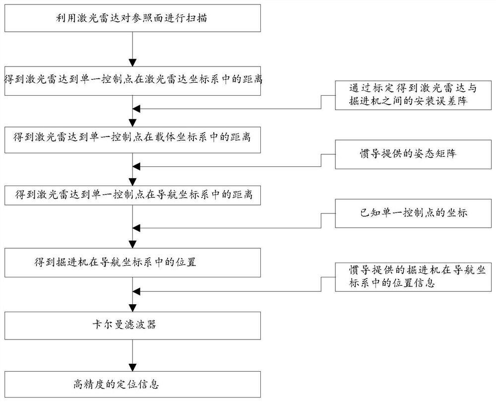
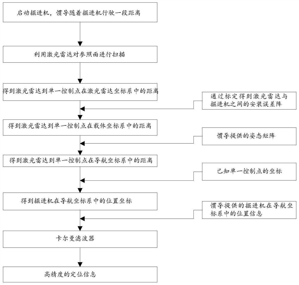
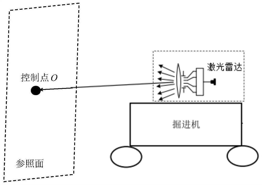
The invention discloses a heading machine positioning method based on inertial navigation and laser radar single-point distance measurement. The method comprises the following steps: a laser radar isused for scanning a tunneling reference surface, wherein a control point exists on the reference surface, coordinates of the control points are known, the distance from the control point to the laserradar is solved, and the distance is converted to a navigation coordinate system by using a mounting error matrix between a heading machine and the laser radar and an attitude matrix provided by an inertial navigation system so as to obtain the position of the heading machine; the value is fused with position information provided by inertial navigation by using a Kalman filter so as to obtain high-precision position information. The positioning method can meet the long-time high-precision positioning and orientating requirements for the heading machine, and has the advantages of passive measurement, capability of establishing an own system, low possibility of interference and accurate positioning. Meanwhile, the invention further discloses a heading machine positioning system based on theinertial navigation and the laser radar single-point distance measurement.

Description

technical field [0001] The invention relates to the technical field of positioning of roadheading machines, in particular to a roadheading machine positioning method and system based on inertial navigation and laser radar single-point ranging. Background technique [0002] The precise positioning and orientation system of the roadheader is a key issue in the excavation of roadways, tunnels, etc. The positioning and orientation system directly affects the efficiency and quality of the roadheader's work. The working environment of roadheaders and other mining construction machinery has large dust, strong noise and poor lighting conditions, which seriously affects the physical and mental health of operators and work efficiency. In order to reduce the workload of roadheader operators and improve the safety of tunneling workers, the roadway Machines are gradually transforming into automation. [0003] The autonomous positioning and orientation system of the roadheader is the key...

Claims


Application Information

Patent Timeline
IPC IPC(8): G01C21/16G01C21/20G01S17/86
CPCG01C21/165G01C21/20G01S17/86
Inventor 韩松来任星宇董晶芦佳振
Owner CENT SOUTH UNIV
Learn More