Multi-source heterogeneous remote sensing data association construction and multi-user data matching method

A remote sensing data, multi-source heterogeneous technology, applied in the field of data processing, can solve the problems of no unified measurement standard, strong user division, and low efficiency, and achieve the effect of realizing use value, accurate recommendation, and fast processing speed

Active Publication Date: 2020-09-15
GEOVIS CO LTD
View PDF18 Cites 23 Cited by
  • Summary
  • Abstract
  • Description
  • Claims
  • Application Information

AI Technical Summary

Problems solved by technology

[0003]In the field of remote sensing data promotion services, the existing systems are users interacting with computer visualization terminals to filter out data from a huge database for remote sensing data browsing, downloading and production; in the field of remote sensing data user portrait construction, the existing system has a relatively strong division of users, generally based on coarse-grained division of industries or business models, such as troops, scientific research institutes, government departments, institutions of higher learning It is impossible to build user portraits at the level of application requirements
[0004]In the era of remote sensing big data, there are various sources, huge data volume, and complex correlations
When users face a daily data growth rate of TB level, the size of single-scene remote sensing data is also GB level. Most of the existing systems call remote sensing data through human-computer interaction. On the one hand, they cannot find the available data in time. Judging the useful information of the extracted data by means of manual interpretation is inefficient and there is no unified measurement standard; in addition, in terms of precise positioning of users, considering the variety of users of remote sensing data, the existing system lacks multi-dimensional understanding of users , cannot combine user information for data usage intention speculation and modeling analysis, and it is difficult to provide accurate recommendation services oriented to user needs

Method used


Image

  • Multi-source heterogeneous remote sensing data association construction and multi-user data matching method
  • Multi-source heterogeneous remote sensing data association construction and multi-user data matching method
  • Multi-source heterogeneous remote sensing data association construction and multi-user data matching method

Examples


Embodiment Construction

[0045] The technical solutions in the embodiments of the present invention will be clearly and completely described below in conjunction with the accompanying drawings in the embodiments of the present invention. Obviously, the described embodiments are only part of the embodiments of the present invention, not all of them. Based on the embodiments of the present invention, all other embodiments obtained by persons of ordinary skill in the art without making creative efforts belong to the protection scope of the present invention.

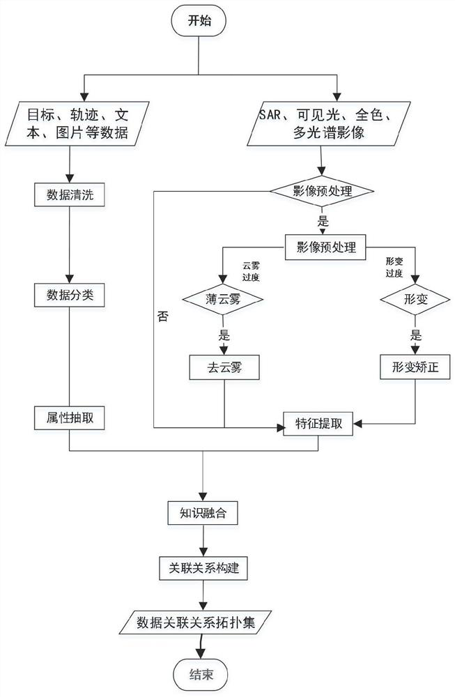
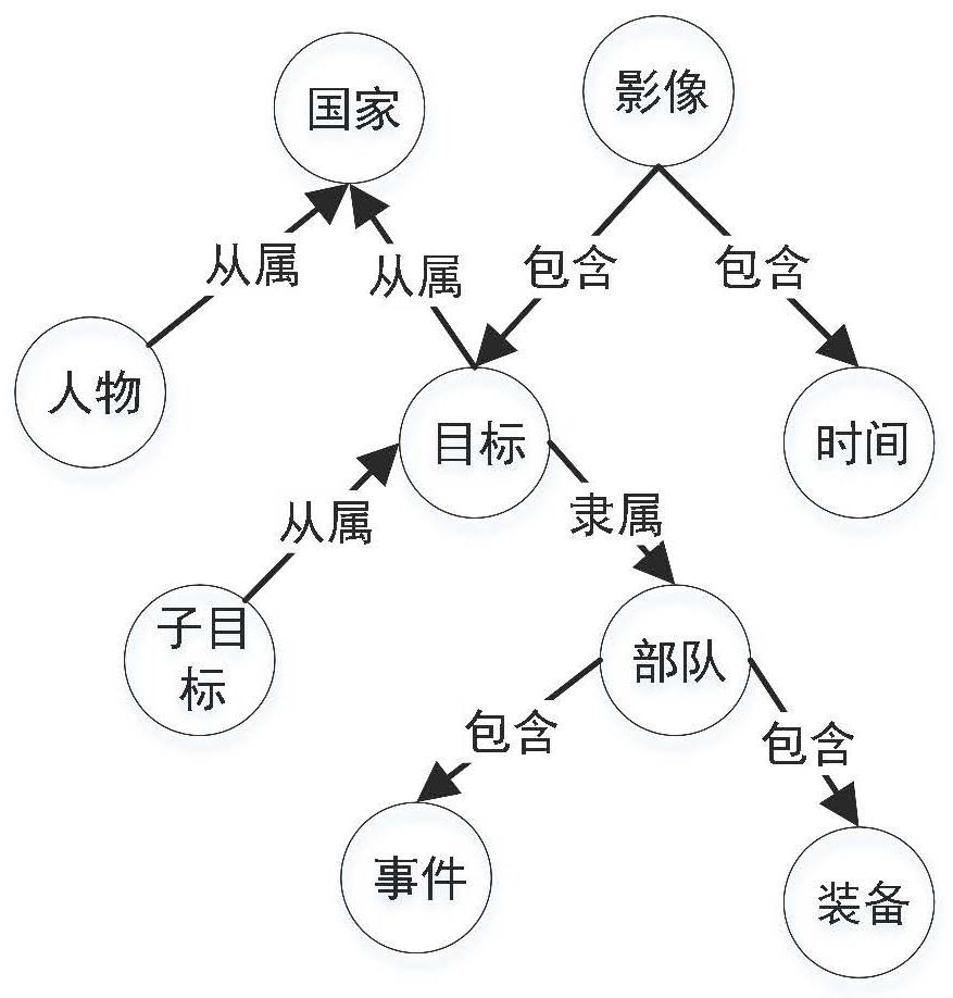
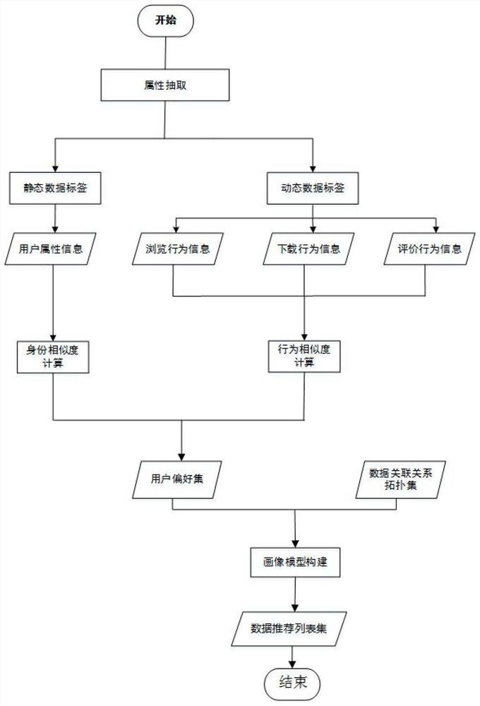
[0046] According to an embodiment of the present invention, a method based on multi-source heterogeneous remote sensing data association construction and multi-user data matching is proposed to construct association relations, and use methods such as data mining, text analysis, and semantic recognition to perform various remote sensing ontology data Feature extraction, model abstraction and standardized description, using knowledge graph technology ...


PUM


Abstract

The invention discloses a multi-source heterogeneous remote sensing data association construction and multi-user data matching method. The multi-source heterogeneous remote sensing data association construction and multi-user data matching method comprises the following steps of 1, inputting a remote sensing service data set and a remote sensing product data set; 2, performing data cleaning and preprocessing; 3, performing data classification modeling; 4, performing knowledge extraction, including attribute extraction of remote sensing business data and feature extraction of remote sensing product data; 5, performing multi-source heterogeneous knowledge fusion, constructing a link relationship for the plurality of knowledge, and fusing attribute similarity of different ontology data according to metadata information extracted from the remote sensing data to construct the link relationship of a plurality of knowledge systems; 6, constructing an association relationship model; 7, miningand analyzing a large amount of collected user identities and behavior data, and constructing a user portrait label; 8, carrying out similarity calculation on the identity and behavior of the user; and 9, constructing a personalized user portrait model, and matching the personalized user portrait model with a result in the association relationship construction model.

Description

technical field [0001] The invention relates to the field of data processing, in particular to a multi-source heterogeneous remote sensing data association construction and multi-user data matching method. Background technique [0002] In recent years, with the rapid development of my country's remote sensing earth observation technology, some fields have been among the top in the world, and remote sensing data are widely used in various fields of national economy and social development. In order to meet the ever-increasing application requirements, the number of satellites continues to increase, the resolution / width of remote sensing images continues to increase, and various remote sensing data such as visible light, hyperspectral, and SAR are acquired in large quantities, reaching more than 10TB per day. For users in different fields, how to Accurately and intelligently identifying user needs, and timely and accurately recommending remote sensing data products to meet the ...

Claims


Application Information

Patent Timeline
Patent Type & Authority Applications(China)
IPC IPC(8): G06F16/2458G06F16/28G06F16/29G06F16/31G06F16/36G06K9/62
CPCG06F16/2465G06F16/29G06F16/284G06F16/367G06F16/316G06F18/214
Inventor 张丽金家栋史经业苏婉艳赵娜杜晓辉孙鑫鑫李双雷马冯郭国龙
Owner GEOVIS CO LTD
Why Eureka
Try Eureka