Supercharge Your Innovation With Domain-Expert AI Agents!

Method and device for building two-dimensional map

A two-dimensional map and ground technology, applied in the field of navigation, can solve the problems of lack of obstacle location range and low accuracy of two-dimensional maps, and achieve the effect of comprehensive obstacle information and high accuracy

Active Publication Date: 2022-05-20
HANGZHOU HIKVISION DIGITAL TECH
View PDF0 Cites 0 Cited by
  • Summary
  • Abstract
  • Description
  • Claims
  • Application Information

AI Technical Summary

Problems solved by technology

Furthermore, in the two-dimensional map established based on the scanning results, the location range of the obstacle is missing, and the accuracy of the two-dimensional map is low

Method used


Image

  • Method and device for building two-dimensional map
  • Method and device for building two-dimensional map
  • Method and device for building two-dimensional map

Examples


Embodiment Construction

[0067] Reference will now be made in detail to the exemplary embodiments, examples of which are illustrated in the accompanying drawings. When the following description refers to the accompanying drawings, the same numerals in different drawings refer to the same or similar elements unless otherwise indicated. The implementations described in the following exemplary examples do not represent all implementations consistent with the present disclosure. Rather, they are merely examples of apparatuses and methods consistent with aspects of the present disclosure as recited in the appended claims.

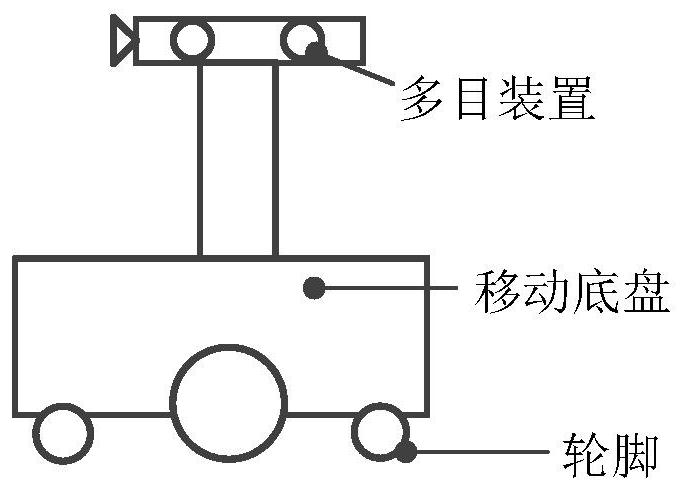
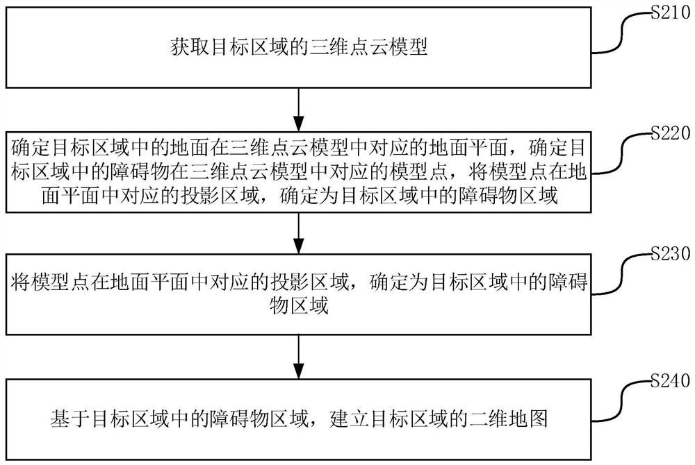
[0068] The embodiment of the present disclosure provides a method for establishing a two-dimensional map, and the method can be executed in a computer device such as a server or a mobile device. Movable devices can be robots, sweeping robots, logistics trolleys, inspection trolleys, etc. The structure of the removable device can be seen figure 1 As shown, it may include components su...


PUM


Abstract

The present disclosure relates to a method and device for establishing a two-dimensional map, and belongs to the technical field of navigation. The method includes: obtaining a three-dimensional point cloud model of the target area; determining a ground plane corresponding to the ground in the target area in the three-dimensional point cloud model, and determining a model point corresponding to an obstacle in the target area in the three-dimensional point cloud model; The projection area corresponding to the model point on the ground plane is determined as the obstacle area in the target area; based on the obstacle area in the target area, a two-dimensional map of the target area is established. Since the image capture component can capture obstacles at various heights and calculate the actual height of the obstacles and the distance relative to the movable device, the two-dimensional map of the target area thus established contains more comprehensive obstacle information. It is not easy to lack information on certain obstacles. The accuracy of the two-dimensional map established by the method provided by the embodiment of the present disclosure is higher.

Description

technical field [0001] The present disclosure relates to the technical field of navigation, in particular to a method and device for establishing a two-dimensional map. Background technique [0002] In the field of autonomous navigation, mobile devices can rely on their own installed lidar to navigate autonomously in the target area. Before autonomous navigation, it is necessary to map the target area to obtain a two-dimensional map of the target area. Wherein, the two-dimensional map is marked with a position range corresponding to each obstacle in the target area. After obtaining the two-dimensional map, the mobile device can plan a traveling route from the current position to the target position based on the two-dimensional map, and then move to the target position along the traveling route. [0003] In the process of mapping the target area, first, the mobile device can travel in the target area. During the process of travel, the target area is scanned by lidar, and a ...

Claims


Application Information

Patent Timeline
Patent Type & Authority Patents(China)
IPC IPC(8): G01C11/02G01C11/04G01C21/20
CPCG01C11/02G01C11/04G01C21/20
Inventor 李裕超蔡宏毛慧浦世亮
Owner HANGZHOU HIKVISION DIGITAL TECH
Features
  • R&D
  • Intellectual Property
  • Life Sciences
  • Materials
  • Tech Scout
  • Unparalleled Data Quality
  • Higher Quality Content
  • 60% Fewer Hallucinations
Learn More