Forest land remote sensing image extraction method and system based on region-of-interest network

A region of interest, remote sensing image technology, applied in instrument, calculation, character and pattern recognition, etc., can solve the problems of uneven distribution, different shapes of forest land, and no method for forest land extraction, and achieve the effect of ensuring the extraction accuracy.

Active Publication Date: 2020-10-02
AEROSPACE INFORMATION RES INST CAS +1
View PDF2 Cites 2 Cited by
  • Summary
  • Abstract
  • Description
  • Claims
  • Application Information

AI Technical Summary

Problems solved by technology

It is conceivable that with the help of classified and marked satellite images released by the platform, new progress will be made in image recognition and analysis algorithms based on satellite images. However, a set of standard data sets has not yet been established for forest land / non-forest land, and due to the different shapes of forest land , uneven distribution, and currently there is no method that is particularly suitable for forest land extraction

Method used


Image

  • Forest land remote sensing image extraction method and system based on region-of-interest network
  • Forest land remote sensing image extraction method and system based on region-of-interest network
  • Forest land remote sensing image extraction method and system based on region-of-interest network

Examples


Embodiment Construction

[0050] The following will clearly and completely describe the technical solutions in the embodiments of the present invention with reference to the accompanying drawings in the embodiments of the present invention. Obviously, the described embodiments are only some, not all, embodiments of the present invention. Based on the embodiments of the present invention, all other embodiments obtained by persons of ordinary skill in the art without making creative efforts belong to the protection scope of the present invention.

[0051] In order to make the above objects, features and advantages of the present invention more comprehensible, the present invention will be further described in detail below in conjunction with the accompanying drawings and specific embodiments.

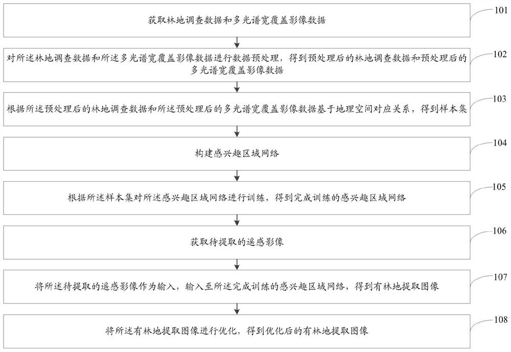
[0052] figure 1 It is a flow chart of the method for extracting forested land remote sensing images based on the region of interest network of the present invention. Such as figure 1 As shown, a forested remote ...


PUM


Abstract

The invention relates to a forest land remote sensing image extraction method and system based on a region-of-interest network. The method comprises steps of acquiring forest land survey data and multispectral wide-coverage image data; performing data preprocessing on the forest land survey data and the multispectral wide-coverage image data to obtain preprocessed forest land survey data and preprocessed multispectral wide-coverage image data; according to the preprocessed forest land survey data and the preprocessed multispectral wide-coverage image data, obtaining a sample set based on a geographic space corresponding relationship; constructing a region-of-interest network; training the region-of-interest network according to the sample set to obtain a trained region-of-interest network;acquiring a remote sensing image to be extracted; taking a remote sensing image to be extracted as input, and inputting the remote sensing image to be extracted into the trained RON to obtain a forest land extraction image; and optimizing the image to obtain an optimized forest land extraction image. According to the invention, high extraction precision of the forest land in different time phaseimages can be ensured.

Description

technical field [0001] The invention relates to the field of remote sensing image extraction of forested land, in particular to a method and system for extracting remote sensing images of forested land based on an area of ​​interest network. Background technique [0002] Forest land / non-forest land information is of great significance to forest resources survey, survey planning and design, and other forestry remote sensing applications. In response to the needs of my country's forest resources survey business application for remote sensing images with multi-spectral bands, high spatial resolution, high-frequency imaging and large-area coverage, the project of rapid identification of forest land / non-forest land in remote sensing images was carried out to improve the efficiency of forest resource surveys and facilitate The planning and design of forest resources can make remote sensing images serve my country's forestry development and ecological environment construction. [0...

Claims


Application Information

Patent Timeline
Patent Type & Authority Applications(China)
IPC IPC(8): G06K9/00G06K9/32G06K9/34G06K9/62
CPCG06V20/194G06V20/188G06V10/26G06V10/25G06F18/253G06F18/214
Inventor 岳安志李伟桂媛媛
Owner AEROSPACE INFORMATION RES INST CAS
Why Eureka
Try Eureka