
Smart city ground parking space image processing method based on artificial intelligence and CIM

An artificial intelligence, urban technology, applied in image data processing, graphic image conversion, character and pattern recognition, etc., can solve problems such as time-consuming and labor-intensive, waste of human resources, and inability to detect, improve parking space utilization, and reduce resources. waste, and the effect of accurate output

Inactive Publication Date: 2020-10-16
郑州迈拓信息技术有限公司
View PDF0 Cites 8 Cited by
  • Summary
  • Abstract
  • Description
  • Claims
  • Application Information

AI Technical Summary

Problems solved by technology

Based on the time-consuming and labor-intensive and lack of real-time problems of human detection, the currently proposed parking space detection methods based on computer vision generally fall into two categories:
One is to assist in judging the use of parking spaces by detecting obstacles such as ground locks. This method solves the real-time problem, but the main defect is that the placement of obstacles still requires personnel to implement, so there is still a waste of human resources; the other is By classifying the collected images at the pixel level, it is possible to detect whether the vehicle is parked in a specified area such as a parking space, but it cannot detect whether the vehicle is parked in a specified area.
[0003] The existing detection method for vehicles crossing the parking line is to combine the obtained wheel and front information with the parking space line to judge whether the vehicle has crossed the parking line. However, in real life, the wheels and the front of the car are easily blocked by other objects, resulting in The obtained wheel and front information is inaccurate, and it is easy to get wrong judgment results

Method used


Image

  • Smart city ground parking space image processing method based on artificial intelligence and CIM
  • Smart city ground parking space image processing method based on artificial intelligence and CIM
  • Smart city ground parking space image processing method based on artificial intelligence and CIM

Examples


Embodiment

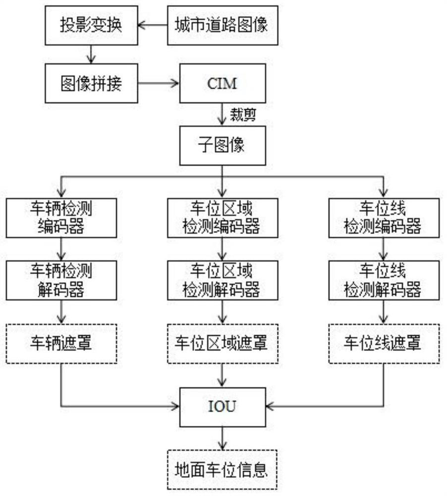
[0031] Urban roads are divided into several sub-areas, and each sub-area is equipped with a camera to collect road information. The image range collected by each sub-area can cover the entire urban road area, and the images between adjacent sub-areas have a certain range. The coincidence of the images is convenient for the image stitching operation of the subsequent real-time imaging module, wherein the resolution and refresh rate of the cameras in each sub-area adopt the same settings.

[0032] Perform projective transformation on each sub-region image of the same frame, and project each sub-region image into the same plane. The embodiment calls this plane a composite panoramic plane, specifically:

[0033] In the embodiment, the plane where a certain sub-region image is located is used as a compound panoramic plane, and the original point of the sub-region image is used as the origin point of the panoramic image. This operation can improve the speed of image processing. Takin...


PUM


Abstract

The invention provides a smart city ground parking space image processing method based on artificial intelligence and CIM, and the method comprises the steps: carrying out the projection transformation and image splicing of a city road image collected by a camera, and projecting the city road image to a ground plane of the city road CIM to obtain a city road panorama; cutting the urban road panorama to obtain a plurality of sub-images; sending the sub-images into a semantic segmentation network, processing the sub-images to obtain a vehicle mask, a parking space area mask and a parking space line mask, calculating an IoU between the vehicle mask and the parking space area mask and an IoU between the vehicle mask and the parking space line mask, and judging ground parking space informationbased on the IoU and a set threshold value; transmitting the ground parking space information to the CIM, carrying out the visual processing of the data through employing the Web GIS technology, and displaying the ground parking space information while carrying out the real-time imaging. The method not only can detect whether the vehicle is parked in the parking space in real time, but also can detect whether one vehicle occupies two parking spaces, thereby improving the utilization rate of the parking spaces.

Description

technical field [0001] The invention relates to the fields of artificial intelligence and intelligent transportation, in particular to an image processing method for ground parking spaces in an intelligent city based on artificial intelligence and CIM. Background technique [0002] Nowadays, for the parking space information of ground parking spaces, the general method is manual method. Through the inspection behavior of inspection personnel, information such as irregular parking, parking space utilization rate, and parking space usage time can be obtained. Due to the time-consuming and labor-intensive and lack of real-time problems of human detection, there are generally two parking space detection methods based on computer vision proposed so far. One is to assist in judging the use of parking spaces by detecting obstacles such as ground locks. This method solves the real-time problem, but the main defect is that the placement of obstacles still requires personnel to implem...

Claims


Application Information

Patent Timeline
Patent Type & Authority Applications(China)
IPC IPC(8): G06K9/00G06K9/34G06K9/62G06T3/40
CPCG06T3/4038G06V20/54G06V10/267G06F18/214
Inventor 邢李蓉
Owner 郑州迈拓信息技术有限公司
Learn More