Map drawing method and system, terminal and storage medium

A map drawing and map technology, applied in image data processing, 2D image generation, instruments, etc., can solve problems such as no interaction

Pending Publication Date: 2020-10-23
CITY CLOUD TECH HANGZHOU CO LTD
View PDF0 Cites 2 Cited by
  • Summary
  • Abstract
  • Description
  • Claims
  • Application Information

AI Technical Summary

Problems solved by technology

[0002] At present, there are not too many tools that can make GIS (geographic information) data in the market, so it is not easy for non-technical personnel to make a complete and correct geographic information data. There are only a few GIS (geographic information) data production tools (such as arcgis) does not have a relatively simple interaction method, and these tools still require users to have a certain professional knowledge reserve to use

Method used


Image

  • Map drawing method and system, terminal and storage medium
  • Map drawing method and system, terminal and storage medium
  • Map drawing method and system, terminal and storage medium

Examples


Embodiment Construction

[0043] The following will clearly and completely describe the technical solutions in the embodiments of the present invention with reference to the accompanying drawings in the embodiments of the present invention. Obviously, the described embodiments are only some, not all, embodiments of the present invention. Based on the embodiments of the present invention, all other embodiments obtained by persons of ordinary skill in the art without creative efforts fall within the protection scope of the present invention.

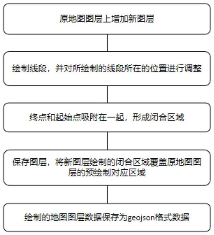
[0044] see figure 1 As shown, it shows a map drawing method provided by an embodiment of the present invention.

[0045] Operate on electronic equipment, preferably use a computer for map drawing, draw and generate seamless gis data through visual operation.

[0046] It is preferred to load the base map on the software system and add a new layer to the original map layer;

[0047] First, draw a line segment, draw at least one line segment, and adjust the position...


PUM


Abstract

The invention discloses a map drawing method and system, a terminal and a storage medium, and relates to the technical field of map drawing. The method comprises the steps of: responding to a click event on a new image layer, forming drawing points at a click position, automatically generating a straight line segment according to the generation sequence of the drawing points to form an initial line segment, and moving the drawing point or a to-be-moved point on the initial line segment to enable the drawing point or the to-be-moved point on the new image layer to correspond to a pre-drawing position on an in-situ image layer; moving one of the start point or the end point to merge the start point or the end point to form a closed area or drawing at least one initial line segment and an original initial line segment to form a closed area; and covering the pre-drawing corresponding area of the in-situ image layer with the closed area drawn by the new image layer. The invention further comprises a system for drawing piled soil and a device which is provided with the system and can use the method. According to the method, system, terminal and storage medium of the invention, the difficulty of making geographic information data is reduced through a graphical interface.

Description

technical field [0001] The invention belongs to the technical field, and in particular relates to a map drawing method, system, terminal and storage medium. Background technique [0002] At present, there are not too many tools that can make GIS (geographic information) data in the market, so it is not easy for non-technical personnel to make a complete and correct geographic information data. There are only a few GIS (geographic information) data production tools (such as arcgis) does not have a relatively simple interaction method, and these tools still require users to have a certain professional knowledge reserve before they can be used. Contents of the invention [0003] The purpose of the present invention is to provide a map drawing method, system, terminal and storage medium, which reduces the difficulty of making geographical information data through a graphical interface. [0004] In order to solve the problems of the technologies described above, the present in...

Claims


Application Information

Patent Timeline
IPC IPC(8): G06T11/20G06F3/0484
CPCG06T11/206G06T11/203G06F3/04845
Inventor 郁强杨子初胡建华刘仁万李绍光
Owner CITY CLOUD TECH HANGZHOU CO LTD
Why Eureka
Try Eureka