Unmanned aerial vehicle three-dimensional path planning method based on improved whale algorithm in urban environment

A technology for urban environment and path planning, applied in three-dimensional position/channel control, vehicle position/route/altitude control, instruments, etc., can solve problems such as slow convergence speed, unsuitable environmental constraints for urban scenes, local optimization, etc. Effects of Convergence Speed ​​and Convergence Accuracy

Active Publication Date: 2020-11-03
HENAN UNIVERSITY
View PDF7 Cites 8 Cited by
  • Summary
  • Abstract
  • Description
  • Claims
  • Application Information

AI Technical Summary

Problems solved by technology

This solution can only ensure that the track does not pass through the threat area with a high probability, but if the planning space is large and the sub-segment is long, the distance between the five points divided is relatively large, and the flight segment between two points cannot be guaranteed. not in threat zone
[0005] When solving NP-hard problems, it is difficult to coordinate and balance the global search and local development of the algorithm. In the early stage of the algorithm, the search space is too large, resulting in slow convergence speed, and in the algorithm In the later stage of iteration, it is easy to fall into local optimum and premature convergence, etc., especially when the problem scale is large, the convergence accuracy of the algorithm cannot be guaranteed
[0006]Most UAV 3D path planning algorithms are aimed at random mountainous terrain, and the environmental constraints considered are not suitable for urban scenes

Method used


Image

  • Unmanned aerial vehicle three-dimensional path planning method based on improved whale algorithm in urban environment
  • Unmanned aerial vehicle three-dimensional path planning method based on improved whale algorithm in urban environment
  • Unmanned aerial vehicle three-dimensional path planning method based on improved whale algorithm in urban environment

Examples


Embodiment Construction

[0029] The following will clearly and completely describe the technical solutions in the embodiments of the present invention with reference to the drawings in the embodiments of the present invention. Based on the embodiments of the present invention, all other embodiments obtained by persons of ordinary skill in the art without making creative efforts belong to the protection scope of the present invention.

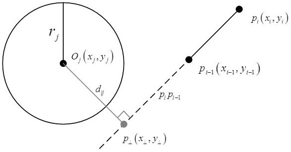
[0030] figure 1 In, O j (x j ,y j ) is the center of the threat zone j; r j is the radius of threat zone j; p i-1 (x i-1 ,y i-1 ) and p i (x i ,y i ) is the endpoint coordinates of the i-th flight segment; p i p i-1 is the straight line where the i-th flight segment is located; p ⊥ (x ⊥ ,y ⊥ ) is the center O j (x j ,y j ) to the line p i p i-1 feet; d ij is the center O j (x j ,y j ) to the line p i p i-1 distance.

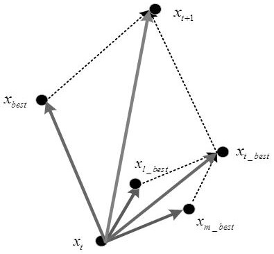
[0031] figure 2 in, x t is the current position of the individual; x m_best is the optimal solution of individual memory; x ...


PUM


Abstract

According to the unmanned aerial vehicle three-dimensional path planning method based on the improved whale algorithm in the urban environment, threat area judgment is set, whether a path passes through the threat area or not is determined more accurately, a reasonable cost function is constructed, and the path with low energy consumption, high coverage and no threat becomes a better choice. By setting threat area judgment, whether the path passes through the threat area or not is determined more accurately, a reasonable cost function is constructed, and the path with low energy consumption, high coverage and no threat becomes a better choice. A convergence factor a is set to change with cosine of iteration times in the algorithm, levy flight disturbance is added in the iteration process,and an information exchange surrounding mechanism updates the rest individuals together through an individual historical optimal solution xmbest, a neighborhood optimal solution xlbest and a current iteration optimal solution xbest in algorithm iteration, so that the convergence speed and convergence precision of the algorithm are improved, and falling into a local optimal solution is better avoided.

Description

technical field [0001] The invention belongs to the technical field of three-dimensional path planning for unmanned aerial vehicles, and in particular relates to a three-dimensional path planning method for unmanned aerial vehicles based on an improved whale algorithm in an urban environment. Background technique [0002] With the development of autonomous driving, UAVs are more and more widely used in autonomous driving due to their advantages of flexibility, portability, and low cost. However, due to the limited energy consumption of UAVs, UAVs cannot reach the deployment point In the process, we should pursue a path with low energy consumption, high coverage, and no threat. Therefore, the path planning problem of UAV has become a research focus, especially for the urban environment, the three-dimensional path planning problem considering coverage benefit and threat cost needs to be solved urgently. [0003] The current algorithms for solving path planning problems can be...

Claims


Application Information

Patent Timeline
Patent Type & Authority Applications(China)
IPC IPC(8): G05D1/10
CPCG05D1/101Y02T10/40
Inventor 杜晓玉郭启程李茵茵周素芳周毅
Owner HENAN UNIVERSITY
Why Eureka
Try Eureka