
A multi-directional overflow analysis method on slopes considering the change of surface water depth

A technology of surface water accumulation and analysis methods, applied in design optimization/simulation, instrumentation, calculation, etc.

Inactive Publication Date: 2021-03-05
CHINA INST OF WATER RESOURCES & HYDROPOWER RES
View PDF16 Cites 0 Cited by
  • Summary
  • Abstract
  • Description
  • Claims
  • Application Information

AI Technical Summary

Problems solved by technology

[0003] The technical problem to be solved by the present invention is to overcome the defects of the existing multi-flow flow process simulation technology in low-lying areas of the plain, construct a dynamic digital terrain that considers the depth change of surface water, and based on this creatively propose a dynamic confluence path on the slope Calculation Method of Slope Confluence for Determination and Calculation of Overflow Volume in Multi-flow Directions

Method used


Image

  • A multi-directional overflow analysis method on slopes considering the change of surface water depth
  • A multi-directional overflow analysis method on slopes considering the change of surface water depth
  • A multi-directional overflow analysis method on slopes considering the change of surface water depth

Examples


Embodiment Construction

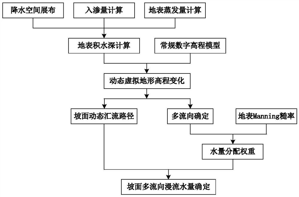
[0065] This embodiment is a multi-directional flow analysis method on slopes considering the change of surface water depth. The calculation process is as follows figure 1 shown. The calculation process of the method described in this embodiment is as follows:

[0066] Step 1: Calculate and determine the surface water depth of the simulated grid unit in the study area

[0067] 1. Obtain the daily precipitation, temperature, wind speed, sunshine, humidity and other meteorological data of the meteorological stations in the study area during the simulation period, and then use the inverse distance square weighted interpolation algorithm to spatially spread the data of the meteorological stations to the simulated grid units in the study area . Calculated as follows:

[0068]

[0069]

[0070]

[0071] In the formula: z and M represent the elevation and meteorological data values ​​of the weather station respectively, dM / dz is the linear change rate of meteorological dat...


PUM


Abstract

The invention relates to a slope multi-flow-direction overflow analysis method considering surface accumulated water depth change. The method comprises the steps of determining the surface accumulatedwater depth, determining the slope dynamic confluence path, determining the slope multi-flow-direction water quantity distribution weight and determining the slope multi-flow-direction overflow waterquantity. The method aims to solve the problem of small surface fluctuation in plain bumpy areas, large ponding area and fast change, achieves accurate depiction of dynamic change of the surface ponding depth and conversion of the water inflow and outflow relationship between the surface ponding depth and peripheral units, solves the problem of application distortion of a conventional digital elevation model, finely simulates the slope multi-flow-direction flooding process, and effectively improves simulation of the surface runoff production process of the plain low-lying area. The method isoriented to plain bumpy area hydrological simulation, and related results can provide basic support for plain bumpy area hydrological model construction and application.

Description

technical field [0001] The invention relates to the technical field of water conservancy engineering, in particular to the simulation of surface flow generation and confluence process in low-lying areas of plains, and in particular to a method for analyzing slope multi-directional overflow flow considering changes in surface water depth. Background technique [0002] The low-lying areas of the plain have the characteristics of low-lying terrain and random flow direction of surface water. The flow direction is not single and fixed, and is easily changed by the change of surface water. It has long been a difficult problem to accurately simulate the process of surface flow generation and confluence in low-lying areas of the plain. For this reason, the theory of multi-directional flow on slopes has been proposed and continuously improved. The basic idea is that water flow should be distributed to all directions with lower elevations in the neighborhood. At present, relevant theo...

Claims


Application Information

Patent Timeline
IPC IPC(8): G06F30/28G06F113/08G06F119/14
CPCG06F30/28G06F2113/08G06F2119/14
Inventor 刘欢胡鹏王建华杨泽凡曾庆慧杨钦慕星
Owner CHINA INST OF WATER RESOURCES & HYDROPOWER RES
Learn More