Airborne tomography SAR three-dimensional point cloud generation method

A technology of three-dimensional point cloud and processing method, which is applied in the direction of radio wave reflection/re-radiation, using re-radiation, measuring devices, etc. It can solve the unseen problems of tomographic SAR three-dimensional imaging processing flow and ignoring spatial adjacency

Active Publication Date: 2020-11-17
AEROSPACE INFORMATION RES INST CAS
View PDF5 Cites 7 Cited by
  • Summary
  • Abstract
  • Description
  • Claims
  • Application Information

AI Technical Summary

Problems solved by technology

However, most of the existing 3D reconstruction algorithms process each range and azimuth unit separately, ignoring the spatial adjacency relationship between pixels of the same target in the SAR image.
In addition, there is no systematic report on the processing flow of tomographic SAR 3D imaging

Method used


Image

  • Airborne tomography SAR three-dimensional point cloud generation method
  • Airborne tomography SAR three-dimensional point cloud generation method
  • Airborne tomography SAR three-dimensional point cloud generation method

Examples


Embodiment Construction

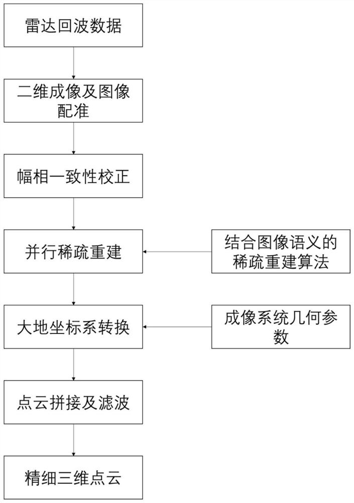
[0033] The invention discloses a method for generating an airborne tomographic SAR point cloud to realize a complete processing flow from airborne SAR data to a three-dimensional point cloud, and provide theoretical and method support for obtaining a high-precision three-dimensional point cloud. It involves the field of radar imaging and signal processing technology, and can use the airborne tomographic SAR system to obtain large-scale three-dimensional point clouds in densely built urban areas. The invention takes into account the characteristics of a large number of overlapping objects in urban areas, uses tomographic SAR technology to efficiently realize large-scale 3D point cloud reconstruction, combines SAR image semantic information to improve 3D imaging effect, can truly reflect 3D information of ground scenes, and expands traditional SAR imaging information dimension. The invention mainly aims at the problem of using SAR multi-angle observation to obtain high-precision...


PUM


Abstract

The invention discloses an airborne tomographic SAR three-dimensional point cloud generation method, and the method obtains the three-dimensional spatial resolution capability through employing an airborne array radar antenna and combining with a two-dimensional SAR imaging technology. The method comprises the following steps: acquiring a two-dimensional SAR image with good array multichannel focusing; performing image registration and inter-channel amplitude-phase consistency correction processing on the two-dimensional SAR image to enable the two-dimensional SAR image to meet the requirementof three-dimensional reconstruction; partitioning the three-dimensional scene by utilizing the two-dimensional image semantic information, processing the partitioned three-dimensional scene in parallel by utilizing a sparse signal processing method, and reconstructing an original three-dimensional point cloud; performing coordinate transformation on the original three-dimensional point cloud in combination with radar system imaging geometric parameters, wherein coordinate transformation is performed from an oblique distance-elevation coordinate system to a geodetic coordinate system; carryingout spatial filtering on the geodetic coordinate system three-dimensional point cloud, filtering stray points out, carrying out splicing in combination with geodetic coordinate system three-dimensional point cloud geographic information, and obtaining the urban area range three-dimensional point cloud.

Description

technical field [0001] The invention relates to the technical field of synthetic aperture radar signal processing, in particular to an airborne tomographic SAR three-dimensional point cloud generation method. Background technique [0002] Traditional SAR can only acquire two-dimensional images. In areas with steep terrain changes and complex environments, three-dimensional targets will be seriously aliased on two-dimensional images, resulting in a large number of targets that cannot be seen, identified, or understood. How to improve the level of SAR image interpretation and application and improve the application efficiency of my country's SAR system is of great significance and urgent demand. [0003] Traditional two-dimensional SAR imaging uses the large bandwidth of the transmitted signal to obtain high resolution in radial distance, and uses the relative motion of the target and radar to obtain high resolution in azimuth. From the perspective of imaging principle, the t...

Claims


Application Information

Patent Timeline
Patent Type & Authority Applications(China)
IPC IPC(8): G01S13/90G01S7/41
CPCG01S13/90G01S7/418
Inventor 焦泽坤丁赤飚仇晓兰周良将
Owner AEROSPACE INFORMATION RES INST CAS
Why Eureka
Try Eureka