Remote sensing image semantic segmentation method, storage medium and computing device

A remote sensing image and semantic segmentation technology, applied in the field of computer vision, can solve the problems of difficult target recognition at different scales, low segmentation accuracy of high-resolution large-scale remote sensing images, etc. Sex-enhancing effect

Pending Publication Date: 2020-12-15
XIDIAN UNIV
View PDF10 Cites 5 Cited by
  • Summary
  • Abstract
  • Description
  • Claims
  • Application Information

AI Technical Summary

Problems solved by technology

[0005] The technical problem to be solved by the present invention is to provide a large-scale remote sensing image semantic segmentation method, storage medium and computing equipment based on spatial information and multi-scale fusion to improve the accuracy of remo

Method used


Image

  • Remote sensing image semantic segmentation method, storage medium and computing device
  • Remote sensing image semantic segmentation method, storage medium and computing device
  • Remote sensing image semantic segmentation method, storage medium and computing device

Examples


Embodiment Construction

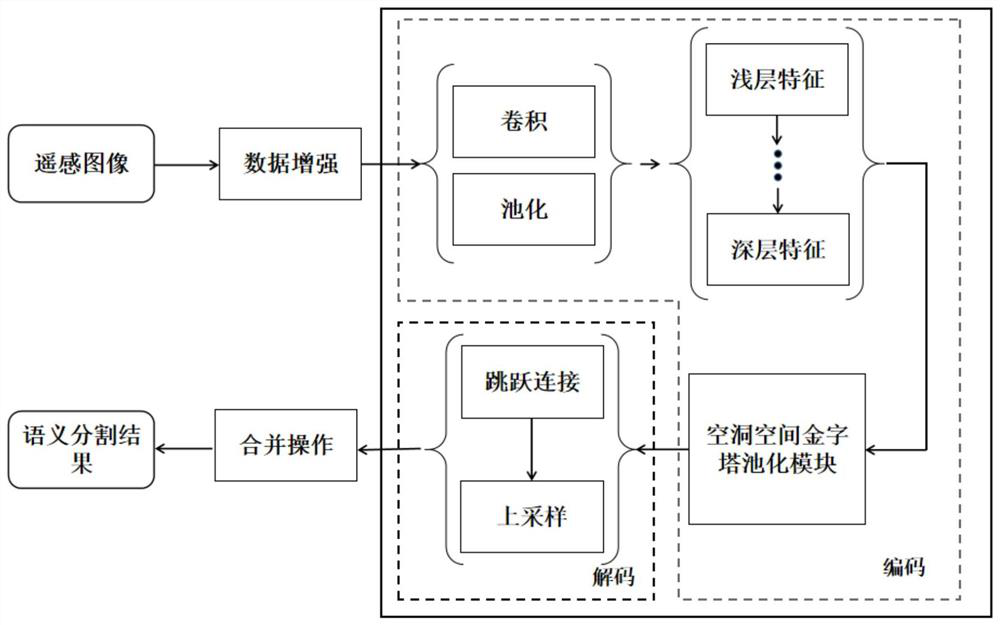
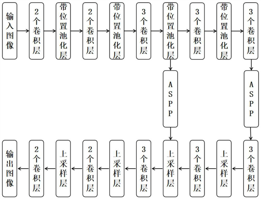
[0044] The present invention provides a large-scale remote sensing image semantic segmentation method based on spatial information and multi-scale fusion, a storage medium and a computing device, which can cut remote sensing images in equal proportions to obtain small remote sensing images that can be processed by a deep network; The network extracts the feature maps of small remote sensing images; in the encoding stage, use the pooling operation with position to pool the feature maps obtained by each layer of the network; use the multi-scale information fusion module to extract the feature maps of different scales extracted by the network Fusion is performed to obtain a feature map containing multi-scale information; in the decoding stage, the feature map of the corresponding position in the encoding stage is connected in series by skip connection; the feature map is up-sampled with the position information obtained in the encoding stage, and the output map of the semantic segm...


PUM


Abstract

The invention discloses a remote sensing image semantic segmentation method, a storage medium and computing equipment, and the method comprises the steps: carrying out equal-proportion cutting of a large-scale remote sensing image and a corresponding label image, and obtaining a small remote sensing image for training; randomly processing the small remote sensing images and the corresponding labelimages, and numbering all the generated training images and the corresponding label images in sequence to obtain an expanded remote sensing image data set for training; constructing a loss function and sequentially putting the training pictures into a semantic segmentation network to obtain a trained remote sensing image semantic segmentation network; traversing all pixels of the whole feature map and carrying out optimization operation, then carrying out merging operation on the randomly cut small remote sensing images, carrying out majority voting on overlapped parts to obtain a segmentation result of the large-scale remote sensing images, and completing feature map merging operation. The method is high in processing speed and good in effect.

Description

technical field [0001] The invention belongs to the technical field of computer vision, and specifically relates to a large-scale remote sensing image semantic segmentation method based on spatial information and multi-scale fusion, a storage medium and a computing device, which are used to identify the land cover type of each pixel on a remote sensing image, and to use Issues such as urban planning and road monitoring. Background technique [0002] Large-scale remote sensing images have been widely used in research in various fields such as traditional geography, environmental science, and earth science due to their advantages of globalization, low cost, and high accuracy. Compared with ordinary images, remote sensing images have the characteristics of large monitoring range, fast data acquisition and short cycle. Secondly, for areas with harsh natural conditions and difficult ground work, it is easier to obtain data. Finally, different remote sensing information can be o...

Claims


Application Information

Patent Timeline
IPC IPC(8): G06K9/00G06K9/34G06K9/46G06K9/62G06N3/04G06N3/08
CPCG06N3/084G06V20/13G06V10/464G06V10/267G06N3/045G06F18/2415
Inventor 古晶卞月林尚荣华巨小杰孙新凯刘芳焦李成
Owner XIDIAN UNIV
Why Eureka
Try Eureka