Traffic demand analysis method based on latitude and longitude coordinates and k-means clustering algorithm

A clustering algorithm and traffic demand technology, applied in computing, computer components, character and pattern recognition, etc., can solve problems such as too simple origin and destination information, difficult to carry out quantitative analysis, etc., to overcome subjectivity and arbitrariness, Fast and efficient analysis, division process science and reasonable effect

Pending Publication Date: 2020-12-15
SOUTHEAST UNIV
View PDF0 Cites 1 Cited by
  • Summary
  • Abstract
  • Description
  • Claims
  • Application Information

AI Technical Summary

Problems solved by technology

[0005] Purpose of the invention: In order to overcome the shortcomings of the existing traffic demand analysis methods, the present invention provides a traffic demand analysis method based on latitude and longitude coordinates and k-means clustering algorithm, which can solve the problem that the origin and destination information is too simple and difficult to quantify analysis flaws

Method used


Image

  • Traffic demand analysis method based on latitude and longitude coordinates and k-means clustering algorithm
  • Traffic demand analysis method based on latitude and longitude coordinates and k-means clustering algorithm
  • Traffic demand analysis method based on latitude and longitude coordinates and k-means clustering algorithm

Examples


Embodiment Construction

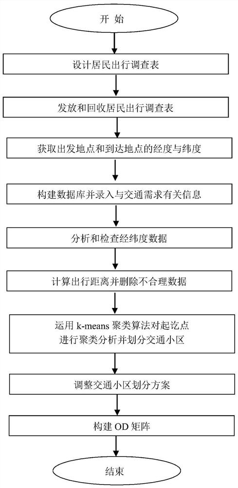
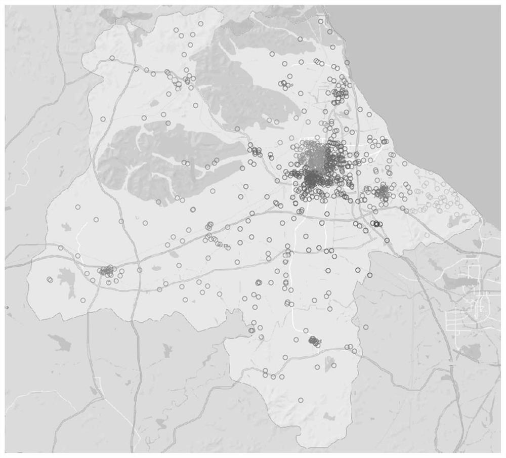
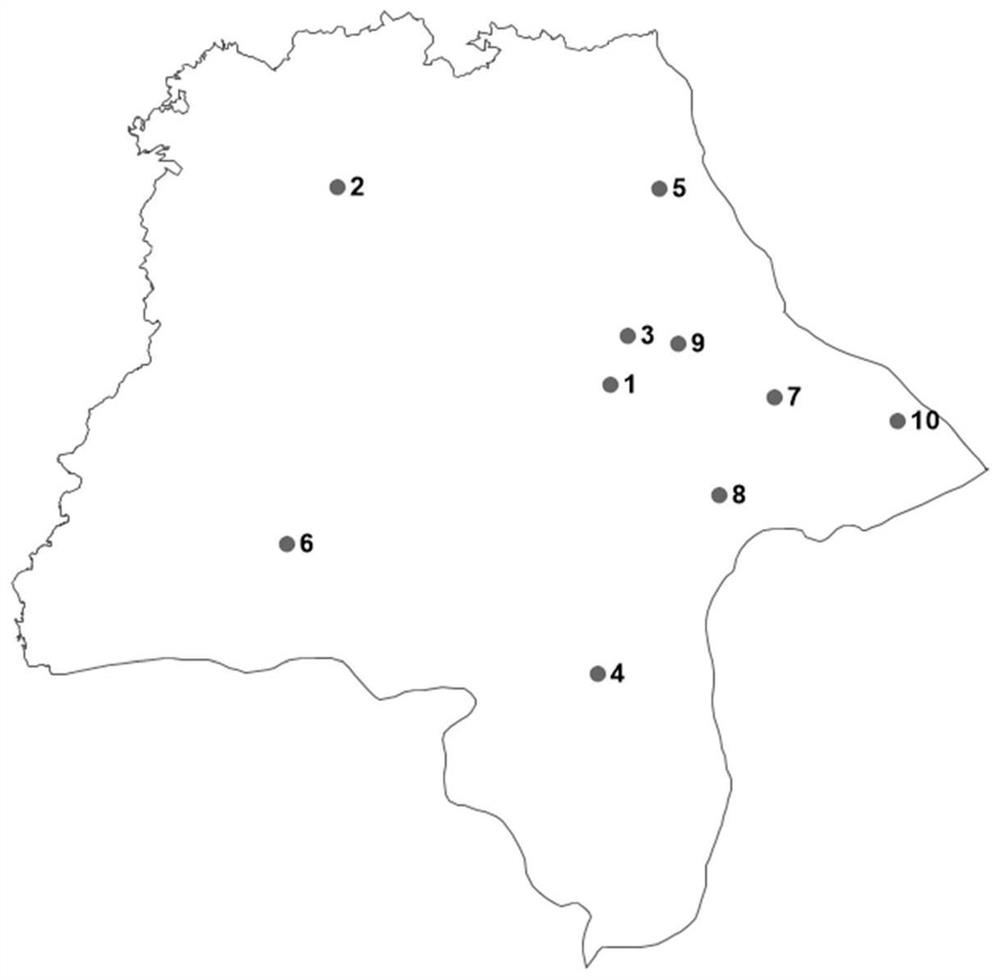
[0046] This method performs cluster analysis on the basis of obtaining the longitude and latitude coordinates of the departure point and arrival point, divides the traffic area according to this, and constructs the OD matrix that reflects the spatial distribution of traffic demand.

[0047] The present invention will be described in further detail below in conjunction with the accompanying drawings. Such as figure 1 Shown, the present invention comprises the following steps:

[0048] 1. Design a travel survey form for residents, including the following important information related to transportation needs: departure time, arrival time, departure location, arrival location, travel purpose, and transportation mode. When designing the resident travel questionnaire, the respondents are required to describe the departure and arrival locations in detail, so that the latitude and longitude of the departure and arrival locations can be accurately found. For example: ×× city ×× distr...


PUM


Abstract

The invention discloses a traffic demand analysis method based on latitude and longitude coordinates and a kmeans clustering algorithm. The method comprises the following steps: (1) designing a resident travel survey table; (2) issuing and recycling a resident travel questionnaire; (3) acquiring longitude and latitude of a departure place and an arrival place; (4) constructing a database, and inputting information related to traffic demands; (5) analyzing and checking the longitude and latitude data; (6) calculating a travel distance, and deleting unreasonable data; (7) performing clustering analysis on the starting point and the destination point by using a k-means clustering algorithm, and dividing traffic cells; (8) adjusting a traffic cell division scheme; and (9) constructing an OD matrix. On the basis of accurately obtaining latitude and longitude coordinates of the departure place and the arrival place, the k-means clustering algorithm is applied to divide traffic zones and create the OD matrix, traffic travel data can be rapidly and efficiently analyzed, and engineering practices of traffic planning, design and management are better met.

Description

technical field [0001] The invention relates to the field of traffic planning, design and management, in particular to a traffic demand analysis method based on latitude and longitude coordinates and a k-means clustering algorithm. Background technique [0002] With the sustained and rapid economic growth, people's living standards continue to improve, the number of motor vehicles has doubled, the contradiction between people, vehicles and roads has become increasingly significant, and the harmful substances emitted by motor vehicle exhaust have gradually become a threat to residents' daily life and health. A major factor in health; carbon emissions in exhaust gases are greenhouse gases that affect global climate change. In order to meet the travel needs of residents, create a fast and efficient transportation network, and promote the sustainable development of the transportation system, scientific and reasonable transportation planning is very necessary, and transportation ...

Claims


Application Information

Patent Timeline
IPC IPC(8): G06Q10/06G06Q50/26G06K9/62
CPCG06Q10/0639G06Q50/26G06F18/23213
Inventor 张国强王斯琨徐炜铃陈峻
Owner SOUTHEAST UNIV
Why Eureka
Try Eureka