High-precision multi-rotor aircraft cooperative positioning method and system

A technology of co-location and rotorcraft, applied in satellite radio beacon positioning system, radio wave measurement system, navigation through speed/acceleration measurement, etc. Positioning requirements and other issues to achieve the effect of eliminating sensor random errors, reducing costs, significant time advantages and accuracy advantages

Active Publication Date: 2021-01-08
BEIJING INSTITUTE OF TECHNOLOGYGY
View PDF6 Cites 8 Cited by
  • Summary
  • Abstract
  • Description
  • Claims
  • Application Information

AI Technical Summary

Problems solved by technology

The map matching method matches the image containing the target acquired by the photoelectric pod with the existing reference map to obtain the target coordinates. When the environmental background is relatively simple or the map cannot be obtained, the use of this method is limited
The angle positioning method only solves the collinear equations to obtain the target coordinates based on the target angle information provided by the photoelectric pod. This method has a better effect and low cost in short-distance target positioning. In long-distance positioning, the positioning error of this method is relatively large
Compared with passive positioning, the active positioning method adds a ranging sensor to obtain target distance information, which is mostly used in long-distance target positioning problems. At the same time, the airborne navigation module is used to provide UAV attitude information to achieve target positioning. Due to the limitation of the accuracy of the on-board navigation module, the positioning results obtained by the single-point positioning method cannot meet the high-precision positioning requirements

Method used


Image

  • High-precision multi-rotor aircraft cooperative positioning method and system
  • High-precision multi-rotor aircraft cooperative positioning method and system
  • High-precision multi-rotor aircraft cooperative positioning method and system

Examples


Embodiment

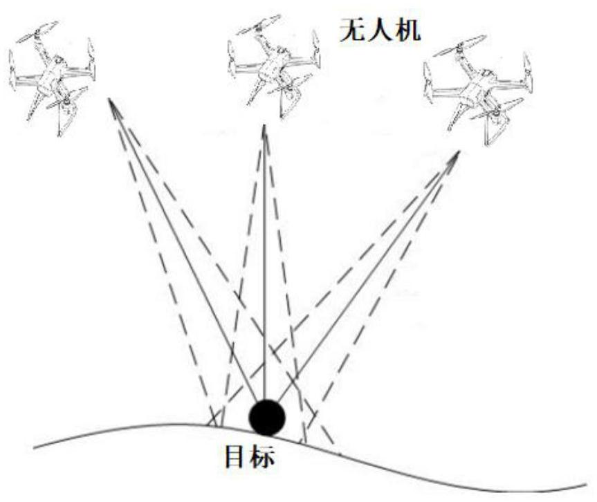
[0110] Simulate the multi-UAV positioning target, set the number of UAVs to 3, and when the UAV is 3000m away from the target, the camera of the photoelectric pod detects the target, locks the target, and the laser rangefinder starts For target distance measurement, the UAV itself collects data at a flight speed of 10m / s, and records the data of each sensor (including integrated navigation module, photoelectric pod, and laser range finder).

[0111] The noise of each sensor obeys the Gaussian distribution, which is Gaussian white noise with a mean value of zero. The error level of each sensor parameter is shown in Table 1:

[0112] Table 1

[0113]

[0114]

[0115] In order to speed up the convergence of the target position estimation error curve, after the UAV stabilizes the target, it also maneuvers itself to obtain the measurement value of the target when the aircraft is in different relative positions. Assuming that the speed of the three drones is 10m / s, the flyin...


PUM


Abstract

The invention provides a high-precision multi-rotor aircraft cooperative positioning method and system. The method comprises the steps: selecting a target needing to be located; acquiring informationdata by n unmanned aerial vehicles, the information data comprising parameter information of the unmanned aerial vehicles, target sight angle information and distance information between the unmannedaerial vehicles and a target; and processing the information data to obtain an estimated value of the target position. According to the method provided by the invention, multiple unmanned aerial vehicles are adopted to cooperatively acquire information, and the installation error between the photoelectric pod and the integrated navigation module is introduced into the least square model, so that high-precision positioning of a long-distance target in a short time is realized under the condition that the precision of an inertial navigation element is relatively low, the positioning precision ishigh, and the time is short.

Description

technical field [0001] The invention relates to the field of target positioning, in particular to a high-precision multi-rotor cooperative positioning method and system. Background technique [0002] Multi-rotor aircraft such as unmanned aerial vehicles have been widely used in military and civilian fields due to their flexibility and good maneuverability. The detection and high-precision positioning technology of ground targets is one of the key technologies for UAV applications. The mainstream target positioning method uses airborne photoelectric equipment to obtain the relative position information of the target, so as to solve the geodetic system coordinates of the target according to the position of the UAV itself. [0003] UAV positioning methods based on photoelectric load equipment can be divided into two categories: active positioning and passive positioning. Among them, passive positioning methods mainly include map matching method and angle positioning method. ...

Claims


Application Information

Patent Timeline
Patent Type & Authority Applications(China)
IPC IPC(8): G01C21/00G01C21/16G01S19/45G01S19/47
CPCG01C21/005G01C21/165G01S19/47G01S19/45
Inventor 林德福杨希雯宋韬侯淼王江郑多张福彪
Owner BEIJING INSTITUTE OF TECHNOLOGYGY
Why Eureka
Try Eureka