Grayscale image matching method and device for geographic image splicing
A technology of image matching and geography, applied in the field of image matching, it can solve problems such as the inability to quickly and accurately match images, and achieve the effects of improving speed and accuracy, reducing data volume, and saving resources and time.
- Summary
- Abstract
- Description
- Claims
- Application Information
AI Technical Summary
Problems solved by technology
Method used
Image
Examples
Embodiment 1
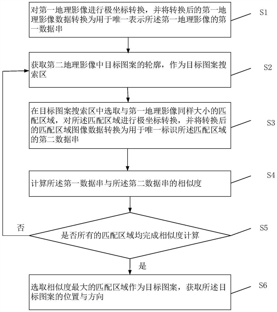
[0040] Such as figure 1 As shown, the present invention provides a gray scale image matching method for geographic image stitching, the method comprising the following steps:
[0041] S1. Perform polar coordinate conversion on the first geographic image, and convert the converted first geographic image data into a first data string uniquely representing the first geographic image;
[0042] In the embodiment of the present invention, the polar coordinate conversion of the first geographic image is performed to perform normalized conversion calculation, and then the data is converted into the first data string uniquely representing the geographic image, from the complex first geographic image with multiple interference factors The data is converted into a simple first data string, which reduces the amount of matching data, and the identity is unique, which reduces the amount of data that needs to be matched during matching, thereby improving the speed and accuracy.
[0043] S2....
Embodiment 2
[0072] This embodiment provides a grayscale matching device for geographic image mosaic, such as Figure 5 shown, including:
[0073] 301. A conversion module, configured to perform polar coordinate conversion on the first geographic image, and convert the converted first geographic image data into a first data string uniquely representing the first geographic image;
[0074] 302. The similarity calculation module is used to repeatedly perform the following steps until the similarity calculation is completed for all matching areas: obtain the outline of the target pattern in the second geographic image as the target pattern search area; select in the target pattern search area A matching area of the same size as the first geographic image, performing polar coordinate conversion on the matching area, and converting the converted matching area image data into a second data string for uniquely identifying the matching area; calculating the second a degree of similarity between...
Embodiment 3
[0078] An embodiment of the present invention provides an electronic device, such as Figure 6 As shown, the electronic device includes a processor 21 and a memory 22, wherein the processor 21 and the memory 22 may be connected through a bus or in other ways.
[0079] The processor 21 may be a central processing unit (CPU). The processor 21 can also be other general-purpose processors, digital signal processors (DSP), application-specific integrated circuits (ASICs), field programmable gate arrays (FPGAs) or other programmable logic devices, discrete gate or transistor logic devices, discrete hardware Chips such as components, or a combination of the above-mentioned types of chips.
[0080] The memory 22, as a non-transitory computer-readable storage medium, can be used to store non-transitory software programs, non-transitory computer-executable programs and modules, such as the grayscale image matching method used for geographical image stitching in the embodiment of the pr...
PUM
 Abstract
Description
Claims
Application Information
 - R&D
- Intellectual Property
- Life Sciences
- Materials
- Tech Scout
- Unparalleled Data Quality
- Higher Quality Content
- 60% Fewer Hallucinations
Browse by: Latest US Patents, China's latest patents, Technical Efficacy Thesaurus, Application Domain, Technology Topic, Popular Technical Reports.
© 2025 PatSnap. All rights reserved.Legal|Privacy policy|Modern Slavery Act Transparency Statement|Sitemap|About US| Contact US: help@patsnap.com


