Coastal zone flooding contour prediction method, device and equipment and readable storage medium

A prediction method and coastal zone technology, applied in instrumentation, calculation, image data processing, etc., can solve the problems of high network density, difficulty in obtaining two-dimensional interpolation data, and large amount of calculation

Active Publication Date: 2021-01-15
河北省地质矿产勘查开发局第五地质大队(河北省海洋地质环境调查中心)
View PDF5 Cites 2 Cited by
  • Summary
  • Abstract
  • Description
  • Claims
  • Application Information

AI Technical Summary

Problems solved by technology

[0003]However, the analysis of the coast submerged by seawater often requires a large amount of calculation, and a tide level network composed of multiple tide level monitoring stations is needed to simulate the fluctuation distribution of the sea surface. Calculation of submerged contours by grid operation of digital terrain
This algorithm requires high network density and two-dimensional distribution of the network, but in reality, the network is often built along the coastline to form a one-dimensional distribution, and it is difficult to obtain two-dimensional interpolation data

Method used


Image

  • Coastal zone flooding contour prediction method, device and equipment and readable storage medium
  • Coastal zone flooding contour prediction method, device and equipment and readable storage medium
  • Coastal zone flooding contour prediction method, device and equipment and readable storage medium

Examples


Embodiment 1

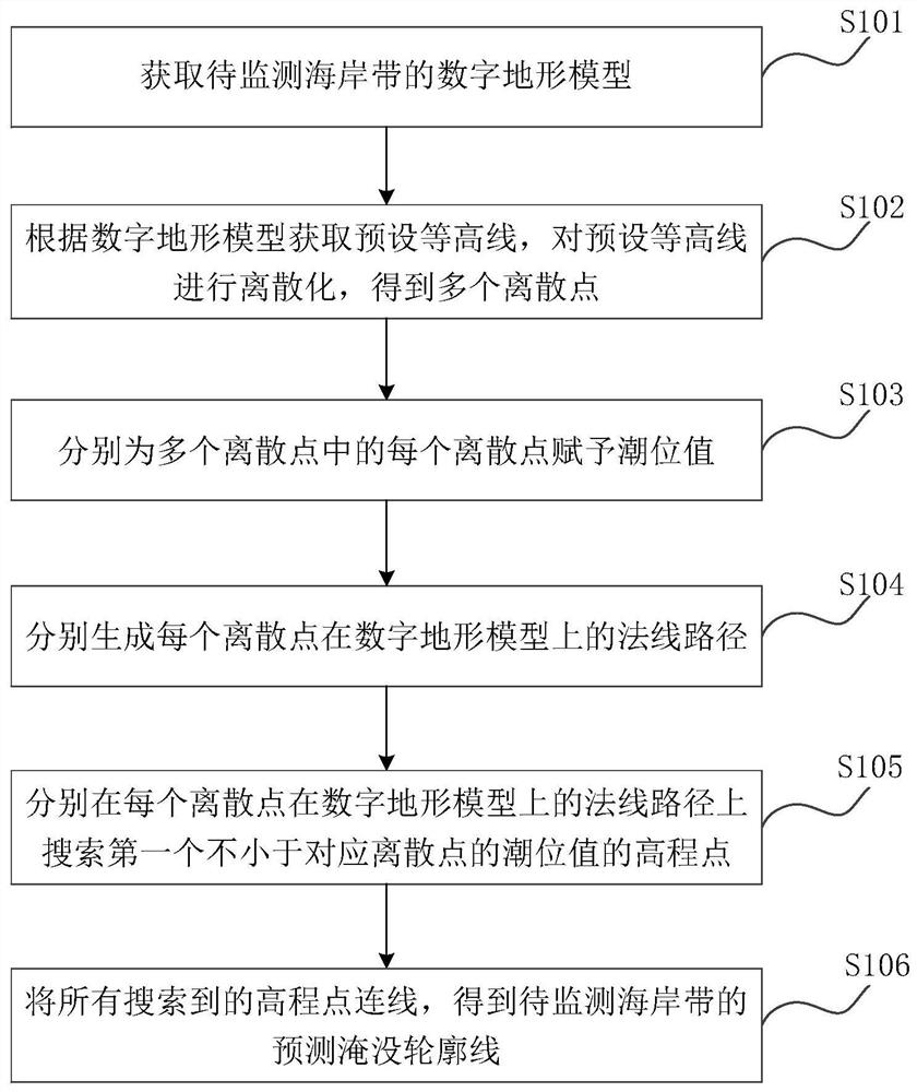
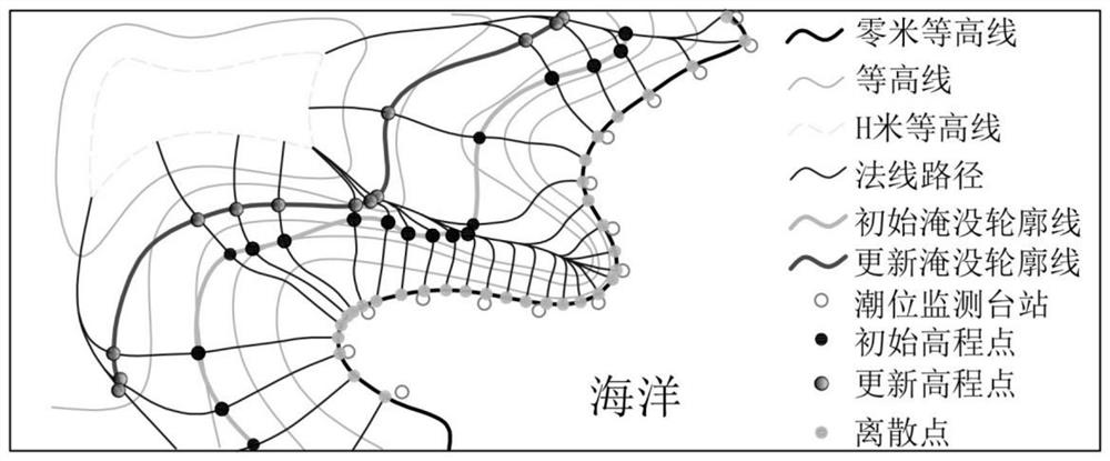
[0053] figure 1 It is a schematic flowchart of a method for predicting coastal zone inundation contours provided in this embodiment. Such as figure 1 As shown, the main flow of the method is described as follows (steps S101-S106):

[0054] Step S101, obtaining a digital terrain model of the coastal zone to be monitored;

[0055] In this embodiment, the digital terrain model of the coastal zone to be monitored can be obtained by using the oblique photography technology of the UAV, which can truly reflect the situation of the ground objects, and embed accurate geographic information and richer image data through advanced positioning technology.

[0056] Specifically, according to the landform characteristics of the coastal zone to be monitored, the model of the drone and the parameters of the tilt camera carried by Wujiren are determined, and then the drone equipped with the tilt camera and signal transmission equipment flies according to the preset path. The oblique photogra...

Embodiment 2

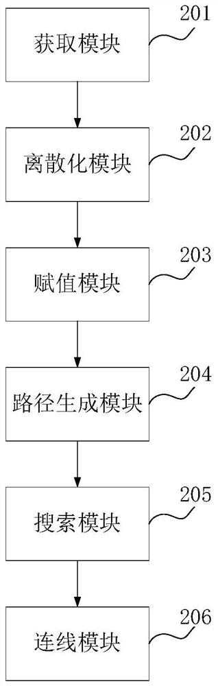
[0075] In order to better implement the above method, an embodiment of the present application provides a coastal zone inundation contour prediction device.

[0076] image 3 A structural block diagram of a coastal zone inundation contour prediction device provided in the embodiment of the present application, such as image 3 As shown, the coastal zone inundation contour prediction device mainly includes:

[0077] An acquisition module 201, configured to acquire a digital terrain model of the coastal zone to be monitored;

[0078] A discretization module 202, configured to obtain preset contour lines according to the digital terrain model, and discretize the preset contour lines to obtain multiple discrete points;

[0079] An assignment module 203, configured to assign a tide level value to each discrete point in a plurality of discrete points;

[0080] Path generating module 204, for generating the normal path of each discrete point on the digital terrain model respective...

Embodiment 3

[0092] In order to better execute the program of the above method, an embodiment of the present application provides an electronic device, and the electronic device 3 may be a mobile phone, a tablet computer, a PC, a server and other devices. Figure 5 It is a structural block diagram of an electronic device provided in the embodiment of the present application. Such as Figure 5 As shown, the electronic device 3 includes a memory 301 and a processor 302 .

[0093] Wherein, the memory 301 may be used to store instructions, programs, codes, code sets or instruction sets. The memory 301 may include a program storage area and a data storage area, wherein the program storage area may store instructions for implementing an operating system, instructions for at least one function, and a coastal zone submergence profile provided in Embodiment 1 above. Instructions of the prediction method, etc.; the storage data area can store the data involved in the coastal zone inundation contou...


PUM


Abstract

The invention relates to a coastal zone inundation contour prediction method anddevice, equipment and a readable storage medium, and belongs to the technical field of storm surge early warning monitoring, and the method comprises the steps: obtaining a digital terrain model of a to-be-monitored coastal zone; obtaining a preset contour line according to the digital terrain model, and discretizing the preset contour line to obtain a plurality of discrete points; endowing each discrete point in the plurality of discrete points with a tide level value; respectively generating a normal path of eachdiscrete point on the digital terrain model; searching a first elevation point which is not less than the tide level value of the corresponding discrete point on a normal path of each discrete pointon the digital terrain model; and connecting all the searched elevation points to obtain a predicted submerging contour line of the coastal zone to be monitored. Two-dimensional analysis is reduced into one-dimensional analysis, only one-dimensional station network tide level data along the coastline is needed, and the calculated amount is small.

Description

technical field [0001] The present application relates to the technical field of storm surge early warning and monitoring, in particular to a method, device, equipment and readable storage medium for predicting coastal submerged contours. Background technique [0002] Storm surge is a catastrophic natural phenomenon caused by strong atmospheric disturbances, such as tropical cyclones (typhoons, hurricanes), extratropical cyclones (cold waves), etc., which cause the sea level to rise and fall abnormally. The sea level rise and fall recorded by coastal tide gauge stations or estuary water level stations is usually a comprehensive feature of sea level changes caused by astronomical tides, storm surges, (earthquake) tsunamis and other long-wave vibrations. Storm surge disasters rank first in marine disasters. Most of the major coastal disasters caused by strong storms in the world are caused by storm surges. The loss of life and property caused by storm surge disasters is shocki...

Claims


Application Information

Patent Timeline
Patent Type & Authority Applications(China)
IPC IPC(8): G06T17/05
CPCG06T17/05
Inventor 杨超邢运涛饶长宏贺晓东杨文李岩松王久良李跃于家术李红超
Owner 河北省地质矿产勘查开发局第五地质大队(河北省海洋地质环境调查中心)
Why Eureka
Try Eureka