Land management surveying instrument convenient for outdoor use and surveying method

A technology for surveying, mapping, and land, applied in surveying instruments, surveying, mapping and navigation, instruments, etc., can solve problems such as troubles, and achieve the effect of reducing operation difficulty, simplifying use procedures, and reducing leveling work.

Inactive Publication Date: 2021-01-22
南通意瑞测绘服务有限公司
View PDF4 Cites 3 Cited by
  • Summary
  • Abstract
  • Description
  • Claims
  • Application Information

AI Technical Summary

Problems solved by technology

[0002] In the fields of state-owned land census, housing and land integration, geographic national conditions detection, balance of occupation and compensation, returning forests to farming, earthwork surveying, and geographic information data collection, etc., it will be widely used in surveying and mapping instruments. An instrument for height difference between points, which measures the height difference between ground points according to the principle of leveling. During use, after adjusting the level of the surveying instrument, if you need to adjust the height of the telescope when using the surveying instrument, you can only adjust the height of the telescope by adjusting the tilt angle of the tripod, and then readjust the height of the telescope. very troublesome

Method used


Image

  • Land management surveying instrument convenient for outdoor use and surveying method
  • Land management surveying instrument convenient for outdoor use and surveying method
  • Land management surveying instrument convenient for outdoor use and surveying method

Examples


Embodiment Construction

[0028] The present invention will be further described in detail below in conjunction with the accompanying drawings and specific embodiments.

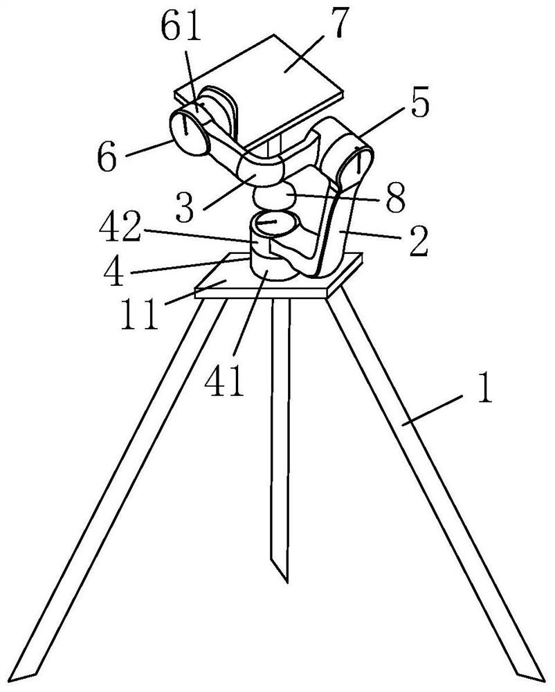
[0029] figure 1 The land management surveying instrument shown is convenient for outdoor use, including a telescope and a tripod 1, and also includes an adjustment balance device; the adjustment balance device includes a first crank arm 2 and a second crank arm 3; the first crank arm is bent at 90° , one end of the first crank arm extends along the x-axis direction, and the end is connected with the first rotator 4, the first rotator is installed on the tripod, and the first rotator arm can be moved along the central axis of the first rotator relative to the tripod part of the rotation; the other end of the first arm extends along the z-axis direction, and the end is connected with the second rotator 5; the second arm is also connected to the second rotator, the first arm and the second arm can be Relatively rotate through the second...


PUM


Abstract

The invention discloses a land management surveying instrument convenient for outdoor use. The instrument comprises a telescope, a tripod and a balance adjusting device. During surveying and mapping,the tripod is opened; the telescope is installed on a telescope platform in parallel, a balance weight is installed below the telescope platform, and after the position of the telescope platform is fixed, the balance weight is detached; a third rotator is kept closed, and a first rotator and a second rotator are opened; and after the tripod is adjusted, the second rotator and the third rotator areclosed, and the telescope can be used for surveying and mapping when the telescope is fixed. According to the invention, the telescope platform can be automatically leveled by using gravity, and manual leveling by using human eyes and hands is not needed any more; through the cooperation of a first crank arm and a second crank arm, the leveled telescope is not influenced when the height or inclination angle of the tripod is adjusted, so that repeated telescope leveling actions are not needed any more, the use procedure is simplified, and the operation difficulty is reduced.

Description

technical field [0001] The invention relates to the field of land management surveying and mapping, in particular to a land management surveying and mapping instrument and a surveying and mapping method that are convenient for outdoor use. Background technique [0002] In the fields of state-owned land census, housing and land integration, geographic national conditions detection, balance of occupation and compensation, returning forests to farming, earthwork surveying, and geographic information data collection, etc., it will be widely used in surveying and mapping instruments. An instrument for height difference between points, which measures the height difference between ground points according to the principle of leveling. During use, after adjusting the level of the surveying instrument, if you need to adjust the height of the telescope when using the surveying instrument, you can only adjust the height of the telescope by adjusting the tilt angle of the tripod, and the...

Claims


Application Information

Patent Timeline
Patent Type & Authority Applications(China)
IPC IPC(8): G01C15/00
CPCG01C15/00
Inventor 周子媛
Owner 南通意瑞测绘服务有限公司
Why Eureka
Try Eureka