Landscaping detection system
A detection system and landscaping technology, applied in measuring instruments, measuring devices, surveying and navigation, etc., can solve the problems of low accuracy, time-consuming and labor-intensive, unfavorable landscaping statistics, etc., to reduce time-consuming and labor-intensive, improve accuracy Effect
- Summary
- Abstract
- Description
- Claims
- Application Information
AI Technical Summary
Problems solved by technology
Method used
Image
Examples
Embodiment 1
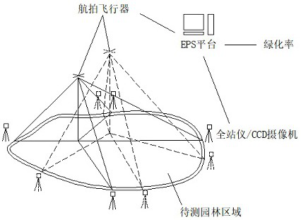
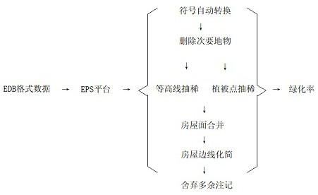
[0033] refer to Figure 1-2 , a landscaping detection system, including EPS platform, greening aerial photography module and field greening sampling inspection module, EPS platform is a platform for secondary development of EPS software through VBScript script, greening aerial photography module includes aerial photography aircraft and signal transceiver, field greening sampling inspection module Including the total station and CCD camera, the aerial photography aircraft performs panoramic capture at different heights to realize the captured images at different heights, and then transmits them to the EPS platform through the signal transceiver. Auxiliary detection, the total station detects the angle between the selected point and the aerial vehicle, and uses the CCD camera to capture the greening scene of the auxiliary point while the total station is operating, and the CCD camera captures the greening scene of the auxiliary point, and selects the green plants on the picture ...
Embodiment 2
[0052] refer to Figure 1-2 , a landscaping detection system, including EPS platform, greening aerial photography module and field greening sampling inspection module, EPS platform is a platform for secondary development of EPS software through VBScript script, greening aerial photography module includes aerial photography aircraft and signal transceiver, field greening sampling inspection module Including the total station and CCD camera, the aerial photography aircraft performs panoramic capture at different heights to realize the captured images at different heights, and then transmits them to the EPS platform through the signal transceiver. Auxiliary detection, the total station detects the angle between the selected point and the aerial vehicle, and uses the CCD camera to capture the greening scene of the auxiliary point while the total station is operating, and the CCD camera captures the greening scene of the auxiliary point, and selects the green plants on the picture ...
PUM
 Abstract
Description
Claims
Application Information
 - R&D
- Intellectual Property
- Life Sciences
- Materials
- Tech Scout
- Unparalleled Data Quality
- Higher Quality Content
- 60% Fewer Hallucinations
Browse by: Latest US Patents, China's latest patents, Technical Efficacy Thesaurus, Application Domain, Technology Topic, Popular Technical Reports.
© 2025 PatSnap. All rights reserved.Legal|Privacy policy|Modern Slavery Act Transparency Statement|Sitemap|About US| Contact US: help@patsnap.com


