Regional impact danger level and domain identification method based on seismic source parameter inversion

A technology of hazard level and parameter inversion, which is applied in seismology, seismic signal processing, measuring devices, etc., can solve problems such as low prediction efficiency, manual blasting, and abnormal changes in index values, and is suitable for programming to realize intelligent, Guaranteed safe operation and clear physical meaning

Pending Publication Date: 2021-02-19
CHINA UNIV OF MINING & TECH +2
View PDF9 Cites 3 Cited by
  • Summary
  • Abstract
  • Description
  • Claims
  • Application Information

AI Technical Summary

Problems solved by technology

[0003] At present, scholars at home and abroad have proposed many microseismic early warning indicators, such as energy, frequency, space-time diffusion, apparent stress, apparent volume, spatial concentration, etc., but the above indicators realize early warning through abnormal changes in index values, such as "abnormal changes in index values". , "High or low value anomalies", only judged from qualitative aspects, resulting in low prediction efficiency
In addition, active and passive CT inversion based on microseismic, which has developed rapidly in recent years, has achieved good results in the detection of shock hazard areas, but its inversion period is long, and active inversion requires manual firing and wiring (resulting in increased cost and labor intensity). Interference with production has become one of the main problems restricting its development
At the same time, some typical mining areas of Poland and China have been observed to have low-energy mine shocks (energy less than 10 4 J) Inducing shock events, but high-energy mine shocks (energy greater than 10 4 J) did not induce a shock event, which is also one of the main problems that lead to an increase in the false alarm rate of monitoring and early warning

Method used


Image

  • Regional impact danger level and domain identification method based on seismic source parameter inversion
  • Regional impact danger level and domain identification method based on seismic source parameter inversion
  • Regional impact danger level and domain identification method based on seismic source parameter inversion

Examples


Embodiment Construction

[0036] The following will clearly and completely describe the technical solutions in the embodiments of the present invention with reference to the accompanying drawings in the embodiments of the present invention. Obviously, the described embodiments are only some, not all, embodiments of the present invention. Based on the embodiments of the present invention, all other embodiments obtained by persons of ordinary skill in the art without making creative efforts belong to the protection scope of the present invention.

[0037] In order to make the above objects, features and advantages of the present invention more comprehensible, the present invention will be further described in detail below in conjunction with the accompanying drawings and specific embodiments.

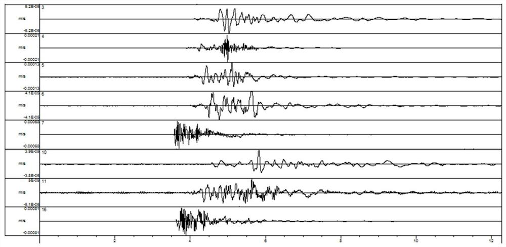
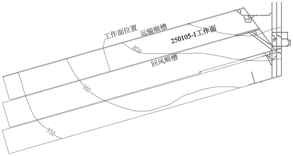
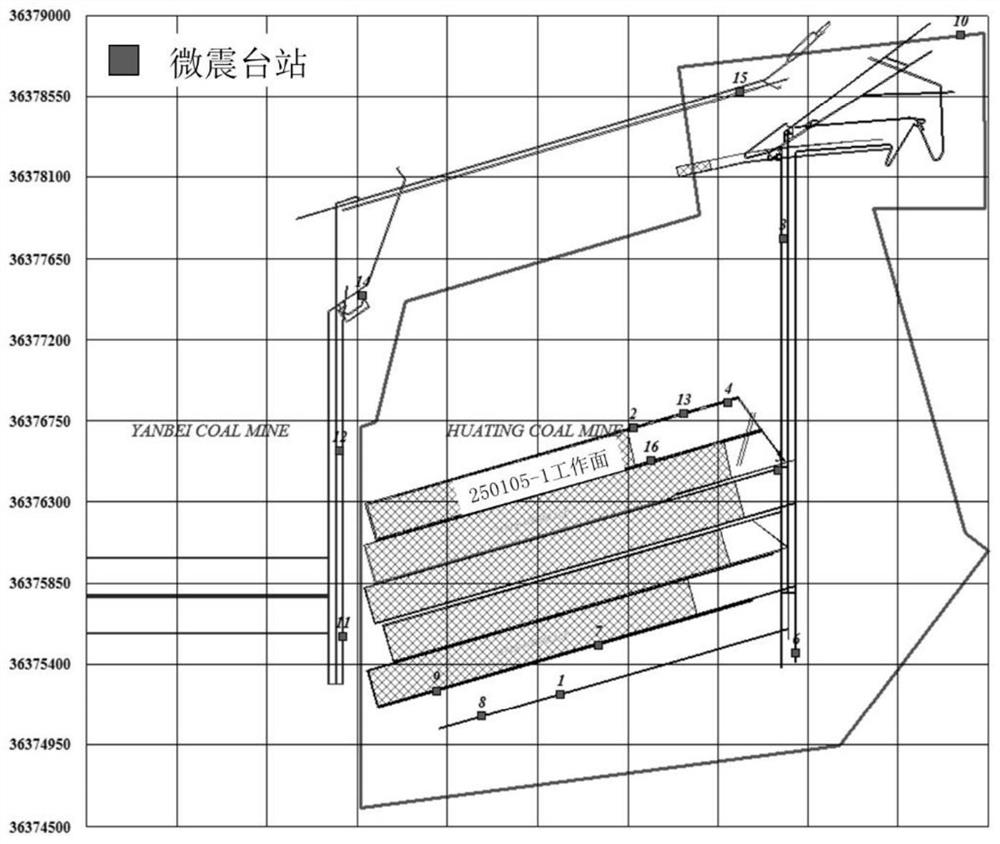
[0038] A number of microseismic events monitored during the mining of Yanbei Coal Mine 250105-1 working face in Gansu were selected for calculation. The waveform records of the microseismic stations are as follows:...


PUM


Abstract

The invention discloses a regional impact danger level and domain identification method based on seismic source parameter inversion. The method comprises the following steps of (1) establishing a target region space coordinate system and screening mine seismic data, (2) establishing an index system for evaluating the impact danger level of the target region, wherein the index system comprises a strength index Q and a dispersion index H, (3) calculating an evaluation index value D of the impact danger level of the target region according to the following formula, (4) judging the impact danger level of the target region according to the evaluation index value D of the impact danger level of the target region, wherein the larger the D value is, the higher the danger level is, and (5) judgingan impact danger region according to the relationship between the closest distance between the center of the seismic source and the roadway and the radius of the seismic source, and formulating a prevention strategy according to the danger level and region of the target region. According to the method, the seismic source parameters are comprehensively utilized to perform impact danger level and domain prediction, the obtained result is convenient to implement on site, and the method established by the invention also has the characteristics of clear physical significance and suitability for programming to realize intellectualization.

Description

technical field [0001] The invention relates to a method for identifying hazard levels and boundaries of rock bursts, in particular to a method for identifying regional impact hazard levels and boundaries based on seismic source parameter inversion for underground microseismic monitoring in coal mines. Background technique [0002] The depth of coal mining in my country is rapidly increasing at a rate of 10-25m per year, resulting in a sharp increase in the stress level of the original rock around the mining space. In addition to the complexity of coal seam occurrence, coal-rock dynamic disasters represented by rock bursts have become obstacles to efficient coal mining. one of the key factors. The prevention and control of rock bursts, especially the accurate detection of rockburst dangerous areas, is one of the world's difficult problems. The geophysical method represented by microseismic monitoring can monitor the shock hazard area in real time and on a large scale, and th...

Claims


Application Information

Patent Timeline
Patent Type & Authority Applications(China)
IPC IPC(8): G01V1/32G01V1/30G01V1/28
CPCG01V1/282G01V1/307G01V1/325G01V2210/40G01V2210/63G01V2210/65
Inventor 曹安业刘耀琪陈凡薛成春白贤栖葛庆马志锋薛建秋
Owner CHINA UNIV OF MINING & TECH
Why Eureka
Try Eureka