Unmanned aerial vehicle for geographic surveying and mapping and using method thereof

A technology of drones and geography, applied in the field of drones, can solve problems such as crashes and affecting the normal progress of surveying and mapping work, and achieve good protection and shock absorption effects

Inactive Publication Date: 2021-02-26
杭州爬藤智能科技有限公司
View PDF6 Cites 2 Cited by
  • Summary
  • Abstract
  • Description
  • Claims
  • Application Information

AI Technical Summary

Problems solved by technology

[0004] The purpose of the present invention is to solve the problem that the existing design does not have a fault-proof anti-drop mechanism, which is easily affected by itself and external factors, and may even crash, which affects the normal progress of surveying and mapping. Man-Machine and How to Use It

Method used


Image

  • Unmanned aerial vehicle for geographic surveying and mapping and using method thereof
  • Unmanned aerial vehicle for geographic surveying and mapping and using method thereof
  • Unmanned aerial vehicle for geographic surveying and mapping and using method thereof

Examples


Embodiment 1

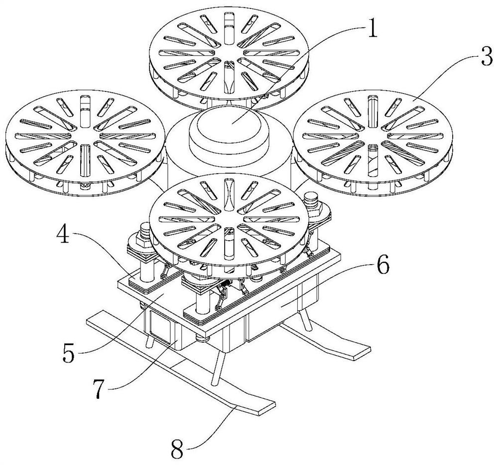
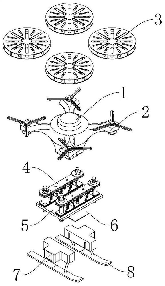
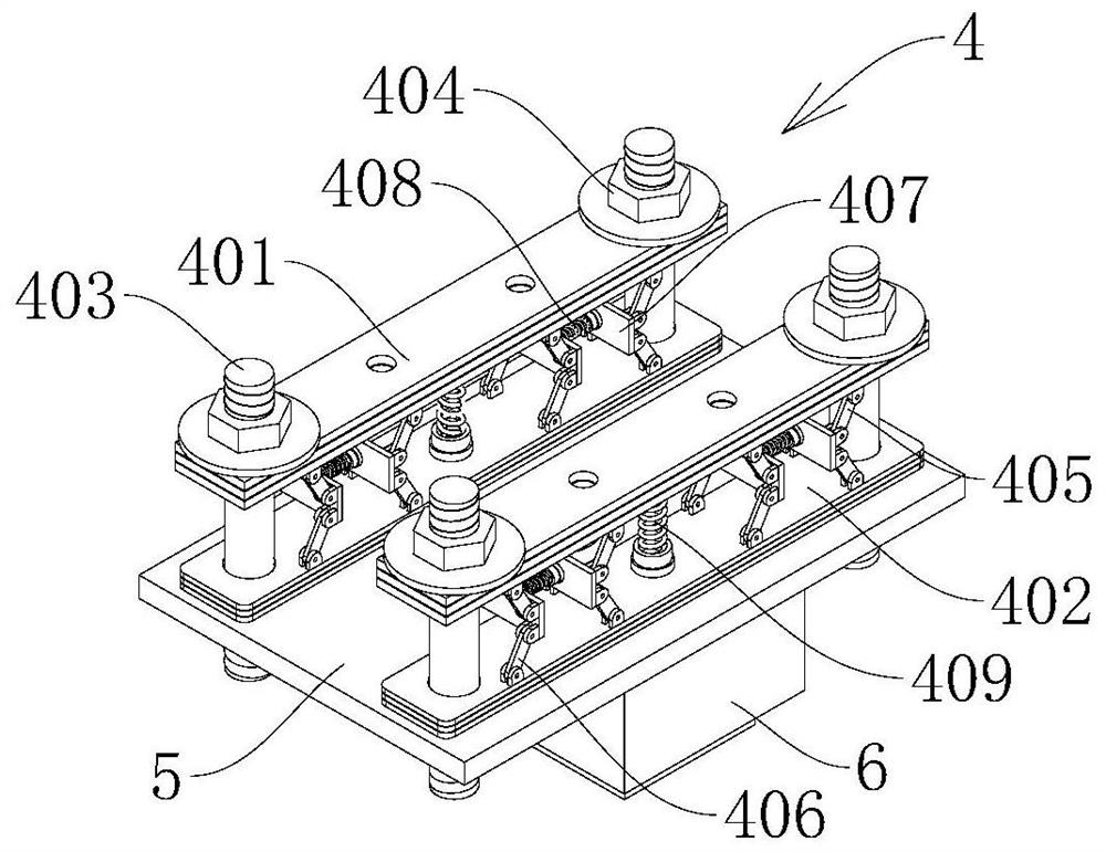
[0032] see figure 1, an unmanned aerial vehicle for geographical surveying and mapping and a method of using the same, comprising an unmanned aerial vehicle for geographical surveying and mapping, the unmanned aerial vehicle for geographical surveying and mapping includes an unmanned aerial vehicle body 1 fixed on the unmanned aerial vehicle main body 1 Rotary wing 2 is installed, and protective frame 3 is arranged around rotary wing 2, and protective frame 3 is fixedly connected with UAV body 1, and the bottom end of UAV body 1 is connected with shock-absorbing connection mechanism 4, and shock-absorbing connection mechanism The bottom end of 4 is connected with connecting plate 5, and the bottom surface of connecting plate 5 is fixedly connected with mounting shell 6, and the interior of mounting shell 6 is fixedly installed with geographical information collecting and photographing device 9, and the both sides of mounting shell 6 is connected with failure anti-drop device 7 ...

Embodiment 2

[0037] see Figure 3-5 , based on Embodiment 1, the difference is that;

[0038] The failure anti-fall device 7 includes a fixed shell 701, the fixed shell 701 is arranged on both sides of the installation shell 6, and the inner outer wall of the fixed shell 701 is fixedly connected with a snap-in buckle 702, and the fixed shell 701 is snap-connected to the fixed shell 702 by the snap-in buckle 702. On the shell 701 , the landing frame 8 is fixedly connected to the bottom surface of the fixed shell 701 , the outer wall of the fixed shell 701 is provided with an opening 703 , and an anti-drop protection mechanism 704 is installed inside the fixed shell 701 .

[0039] The anti-drop protection mechanism 704 includes a high-strength compressed gas tank 7041 and a gas generating agent storage tank 7042. Both the high-strength compressed gas tank 7041 and the gas generating agent storage tank 7042 are fixedly connected with a connecting pipe 7044, and the connecting pipe 7044 is far...

Embodiment 3

[0042] The difference based on embodiment 1 or 2 is that;

[0043] Also included is a method for using a geographic surveying and mapping drone, and the method for using a geographic surveying and mapping drone is applied to a drone for geographic surveying and mapping, including the following steps:

[0044] S1. Check the UAV body 1, the failure anti-drop device 7 and the geographic information collection and shooting device 9 of the UAV used for geographic surveying and mapping to ensure that the above can work normally;

[0045] S2, start the UAV body 1, fly to the top of the area to be surveyed and mapped, and then start the geographic information collection and shooting device 9 to take pictures of the area to be surveyed and mapped, and transmit the captured information back to the ground control center in real time;

[0046] S3, the ground control center processes the real-time image information transmitted back from the UAV body 1, and checks the quality of the aerial ...


PUM


Abstract

The invention discloses an unmanned aerial vehicle for geographic surveying and mapping and a using method thereof, and belongs to the technical field of unmanned aerial vehicles. The unmanned aerialvehicle for geographic surveying and mapping and the using method thereof are provided. The unmanned aerial vehicle for geographic surveying and mapping comprises an unmanned aerial vehicle body, rotating wings are fixedly installed on the unmanned aerial vehicle body, and protection frames are arranged around the rotating wings and fixedly connected with the unmanned aerial vehicle body; the bottom end of the unmanned aerial vehicle body is connected with a damping connecting mechanism, the bottom end of the damping connecting mechanism is connected with a connecting plate, the bottom surfaceof the connecting plate is fixedly connected with a mounting shell, a geographic information collecting and shooting device is fixedly mounted in the mounting shell, fault anti-falling devices are connected to the two sides of the mounting shell, and landing frames are connected to the bottom surfaces of the fault anti-falling devices; the invention effectively solves the problems that the existing design is not provided with a fault anti-falling mechanism, is easily influenced by self and external factors to generate faults and even crash, and affects the normal surveying and mapping work.

Description

technical field [0001] The invention relates to the technical field of unmanned aerial vehicles, in particular to an unmanned aerial vehicle used for geographic surveying and mapping and a method for using the same. Background technique [0002] Surveying and mapping is literally understood as surveying and drawing. It is based on computer technology, photoelectric technology, network communication technology, space science, and information science. It is based on global navigation satellite positioning system (GNSS), remote sensing (RS), and geographic information system (GIS). The technical core is to select the existing feature points and boundaries on the ground and obtain the graphics and position information reflecting the current situation of the ground through measurement means for engineering construction, planning and design and administrative management. [0003] With the development of science and technology and the times, the development of UAV technology has be...

Claims


Application Information

Patent Timeline
Patent Type & Authority Applications(China)
IPC IPC(8): B64C27/00B64C25/62B64D17/72B64D17/80B64D47/08B64D45/00
CPCB64C27/006B64C25/62B64D17/725B64D17/80B64D47/08B64D45/00
Inventor 徐琪
Owner 杭州爬藤智能科技有限公司
Why Eureka
Try Eureka