Unmanned aerial vehicle shot video and map real-time combination method and system

A drone and video technology, applied in the field of image processing, can solve the problems of not being able to know the actual position of the aerial video, not being able to match the coordinate points on the map, not being able to fully understand the scene situation in real time and tracking the event location, etc., so as to achieve convenient viewing Effect

Pending Publication Date: 2021-02-26
SHENZHEN GODO INNOVATION TECH CO LTD
View PDF0 Cites 0 Cited by
  • Summary
  • Abstract
  • Description
  • Claims
  • Application Information

AI Technical Summary

Problems solved by technology

[0005] The purpose of the present invention is to provide a real-time combination method and system for UAV shooting video and map, aiming to solve the problem that the UAV aerial video in the prior art is independent of spatial parameters, and it is impossible to know the actual position corresponding to the aerial video, that is, it is impossible to Matching with the coordinate points on the map, it is impossible to fully understand the on-site situation in real time and track technical issues such as the location of the incident

Method used


Image

  • Unmanned aerial vehicle shot video and map real-time combination method and system
  • Unmanned aerial vehicle shot video and map real-time combination method and system
  • Unmanned aerial vehicle shot video and map real-time combination method and system

Examples


Embodiment Construction

[0038] Embodiments of the present invention are described in detail below, examples of which are shown in the drawings, wherein the same or similar reference numerals designate the same or similar elements or elements having the same or similar functions throughout. The embodiments described below by referring to the figures are exemplary and are intended to explain the present invention and should not be construed as limiting the present invention.

[0039] In describing the present invention, it should be understood that the terms "length", "width", "upper", "lower", "front", "rear", "left", "right", "vertical", The orientation or positional relationship indicated by "horizontal", "top", "bottom", "inner", "outer", etc. are based on the orientation or positional relationship shown in the drawings, and are only for the convenience of describing the present invention and simplifying the description, rather than Nothing indicating or implying that a referenced device or element...


PUM


Abstract

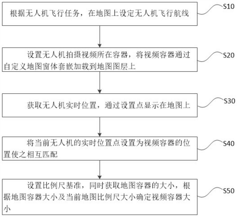
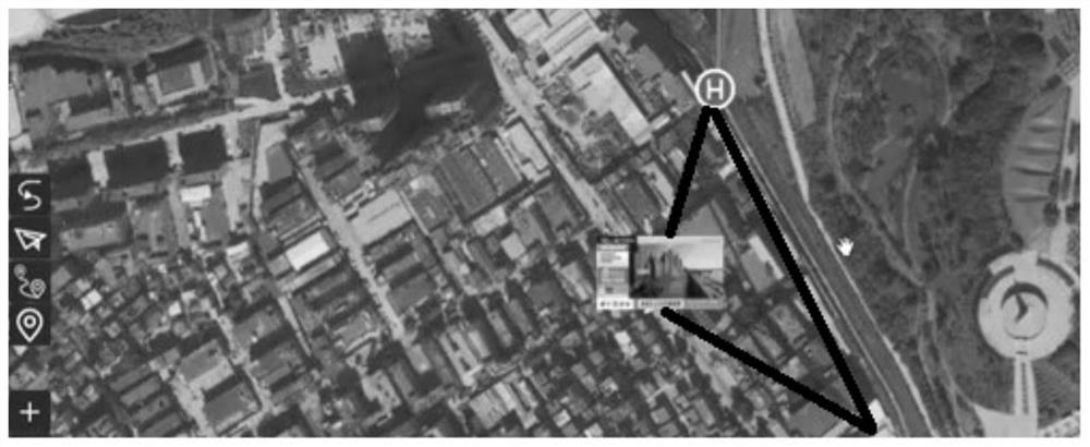
The invention provides an unmanned aerial vehicle video and map real-time combination method and system, and the method comprises the steps: displaying the real-time video information of the real-timeposition of a ground end, setting a container where a video shot by an unmanned aerial vehicle is located, embedding and loading the video container to a map layer through a user-defined map window;setting the current real-time position point of the unmanned aerial vehicle as the position of the video container to be matched with the video container; setting a scale reference, acquiring the sizeof the map container, and determining the size of the video container according to the size of the map container and the current map scale. The position of the video container and the real-time position of the unmanned aerial vehicle are matched and bound to be displayed on the map, so that the aerial video of the unmanned aerial vehicle is combined with the space parameters, the real position corresponding to the aerial video is obtained and matched with the coordinate points on the map, the site condition and the tracking event site are comprehensively known in real time, and convenience inchecking is provided for inspection personnel.

Description

technical field [0001] The invention relates to the field of image processing, in particular to a method and system for combining video captured by a drone with a map in real time. Background technique [0002] Unmanned aircraft, referred to as "UAV", is an unmanned aircraft controlled by radio remote control equipment and its own program control device. UAV has the characteristics of small size, light weight, low cost, flexible operation and high safety, and is widely used in aerial photography, monitoring, search and rescue, resource exploration, agriculture and other fields. [0003] With the continuous promotion and application of drones and other unmanned aerial technologies in the civilian field, drone applications and emergency monitoring are becoming more and more common. UAVs are flexible, low-cost, and easy to use. Many traditional regional monitoring or inspection work are trying to use UAVs to replace old technical means. [0004] However, although the UAV plat...

Claims


Application Information

Patent Timeline
IPC IPC(8): H04N7/18H04B7/185G01S19/42H04W4/029H04W84/18G08G5/00
CPCH04N7/185H04B7/18506G01S19/42H04W4/029H04W84/18G08G5/0082G08G5/0069
Inventor 李坤煌檀瑞青黄建雄赵宝琰和瑞江
Owner SHENZHEN GODO INNOVATION TECH CO LTD
Why Eureka
Try Eureka