A method and system for drawing the risk distribution map of wildfire tripping of power transmission lines
A transmission line and distribution map technology, applied in image data processing, 2D image generation, instruments, etc., can solve problems such as insufficient prediction accuracy and inability to provide reliable guidance for wildfire prevention and control in the power grid, and improve the accuracy of risk prediction. , to avoid the effects of inhomogeneity and discontinuity
- Summary
- Abstract
- Description
- Claims
- Application Information
AI Technical Summary
Problems solved by technology
Method used
Image
Examples
Embodiment 1
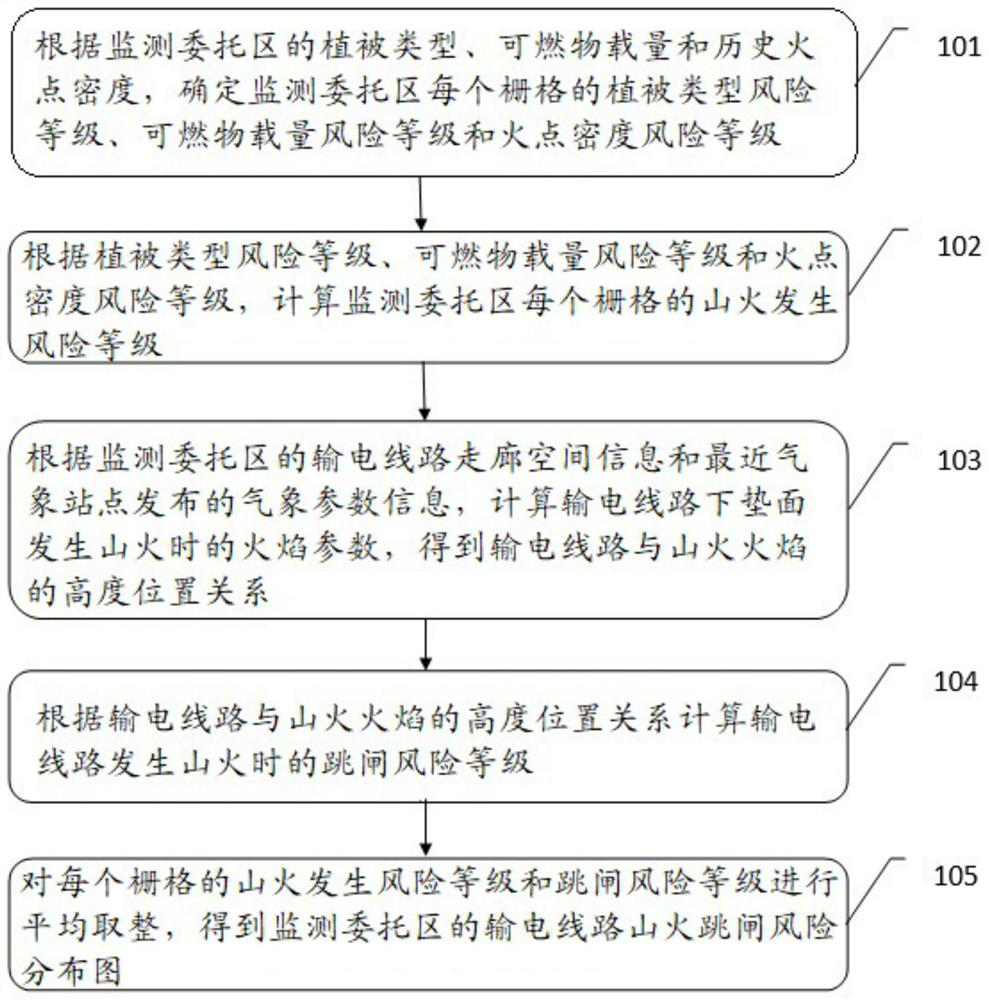
[0058] For ease of understanding, see figure 1 , an embodiment of a method for drawing a transmission line mountain fire trip risk distribution map provided by the present application, including:
[0059] Step 101: Determine the vegetation type risk level, fuel load risk level, and fire point density risk level for each grid in the monitoring entrusted area according to the vegetation type, combustible material load, and historical fire point density in the monitoring entrusted area.
[0060] It should be noted that, in the embodiment of the present application, the vegetation type, fuel load and historical fire point density of the entrusted monitoring area may be obtained by satellite inversion of the entrusted monitoring area. The fire point density risk level can be calculated from the historical fire point raster data, and then determined according to the historical fire point density. The vegetation type risk level, fuel load risk level and fire point density risk level...
Embodiment 2
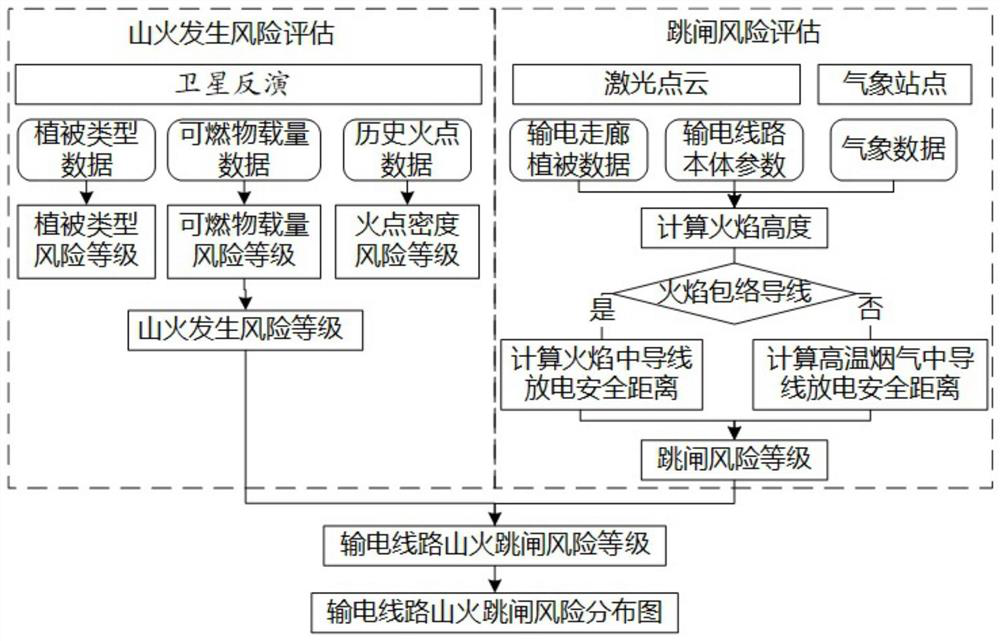
[0082] For ease of understanding, see figure 2 , the present application provides another embodiment of a method for drawing a transmission line mountain fire trip risk distribution map, including:
[0083] Step 201: Determine the vegetation type risk level, fuel load risk level, and fire point density risk level for each grid in the monitoring entrusted area according to the vegetation type, fuel load and historical fire point density in the monitoring entrusted area.
[0084] It should be noted that step 201 in the embodiment of the present application is consistent with step 101 in embodiment 1, and details are not repeated here.
[0085] Step 202: Calculate the risk level of wildfire occurrence for each grid in the entrusted monitoring area according to the risk level of the vegetation type, the risk level of the fuel load and the risk level of the fire point density.
[0086] It should be noted that step 202 in the embodiment of the present application is consistent wit...
Embodiment 3
[0130] This application also provides a system for drawing a risk distribution map of mountain fire trips on transmission lines, including:
[0131] The risk level determination unit is used to determine the vegetation type risk level, combustible load risk level and fire point density risk of each grid in the monitoring entrusted area according to the vegetation type, combustible material load and historical fire point density in the monitoring entrusted area grade.
[0132] The wildfire occurrence risk level calculation unit is used to calculate the wildfire occurrence risk level of each grid in the entrusted monitoring area according to the vegetation type risk level, the fuel load risk level and the fire point density risk level.
[0133] The transmission line and mountain fire position relationship unit is used to calculate the flame parameters when a mountain fire occurs on the underlying surface of the transmission line according to the spatial information of the transm...
PUM
 Abstract
Description
Claims
Application Information
 - R&D
- Intellectual Property
- Life Sciences
- Materials
- Tech Scout
- Unparalleled Data Quality
- Higher Quality Content
- 60% Fewer Hallucinations
Browse by: Latest US Patents, China's latest patents, Technical Efficacy Thesaurus, Application Domain, Technology Topic, Popular Technical Reports.
© 2025 PatSnap. All rights reserved.Legal|Privacy policy|Modern Slavery Act Transparency Statement|Sitemap|About US| Contact US: help@patsnap.com


