High-precision real-time flight navigation calculation method

A calculation method and high-precision technology, applied in navigation calculation tools, navigation, navigation and other directions through speed/acceleration measurement, which can solve problems such as errors, inability to provide navigation information stably, and degraded sensor performance of INS to meet system performance. Requirements, the effect of fast combined navigation calculation

Active Publication Date: 2021-03-12
BEIJING AEROSPACE INST OF THE LONG MARCH VEHICLE
View PDF5 Cites 0 Cited by
  • Summary
  • Abstract
  • Description
  • Claims
  • Application Information

AI Technical Summary

Problems solved by technology

[0002] GNSS (Global Satellite Navigation System) can measure position, speed and time, but it cannot provide stable and correct navigation information in the application scenarios where the aircraft’s working electromagnetic environment is complex or satellite signals are affected; INS (Inertial Navigation System) can realize position , speed and attitude measurement, but as a navigation method of integral calculation, there is an inherent defect that the error accumulates over time; and for the complex attitude movement of the spin aircraft, the performance of the INS sensor will be reduced

Method used


Image

  • High-precision real-time flight navigation calculation method
  • High-precision real-time flight navigation calculation method
  • High-precision real-time flight navigation calculation method

Examples


Embodiment Construction

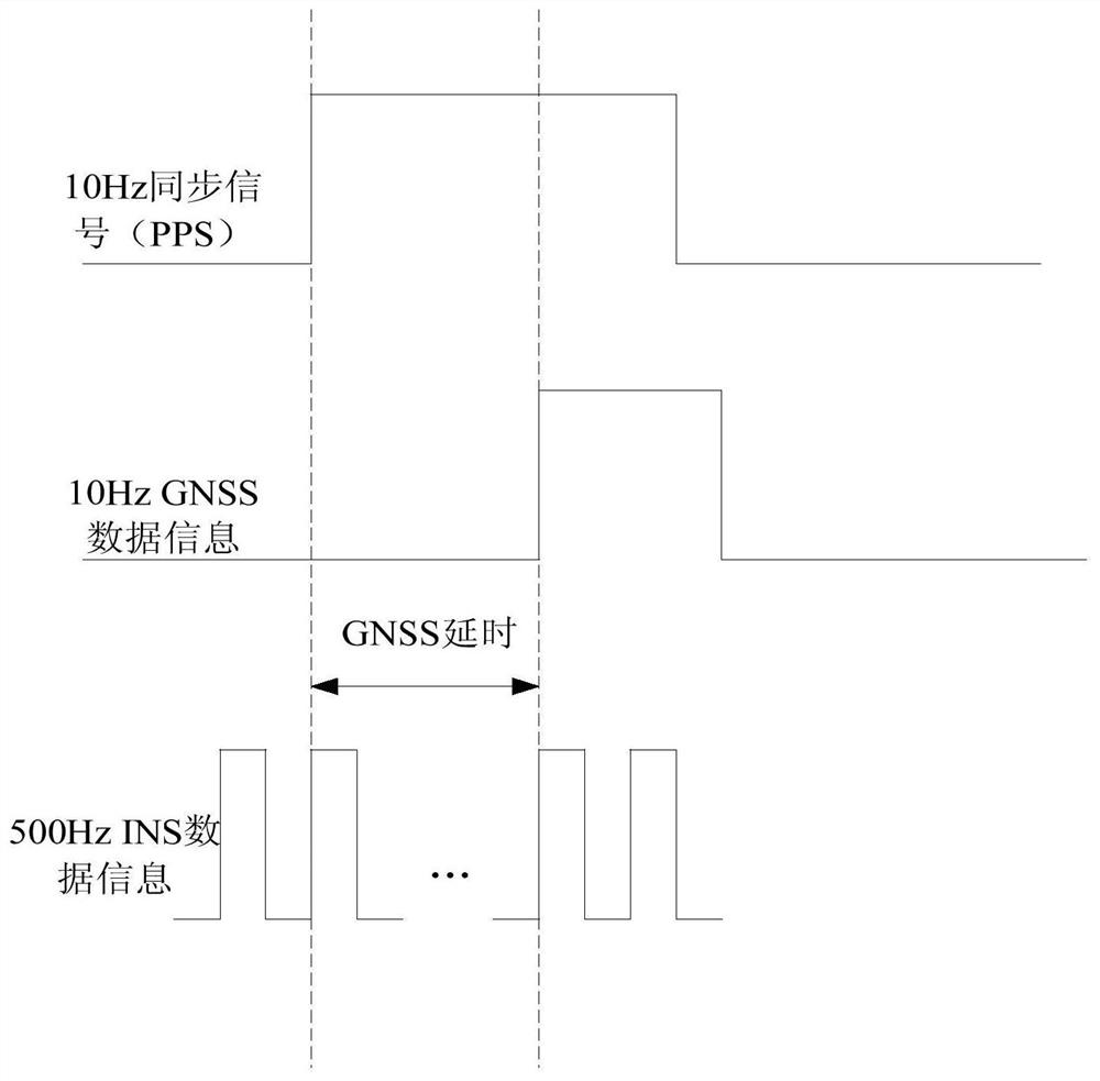
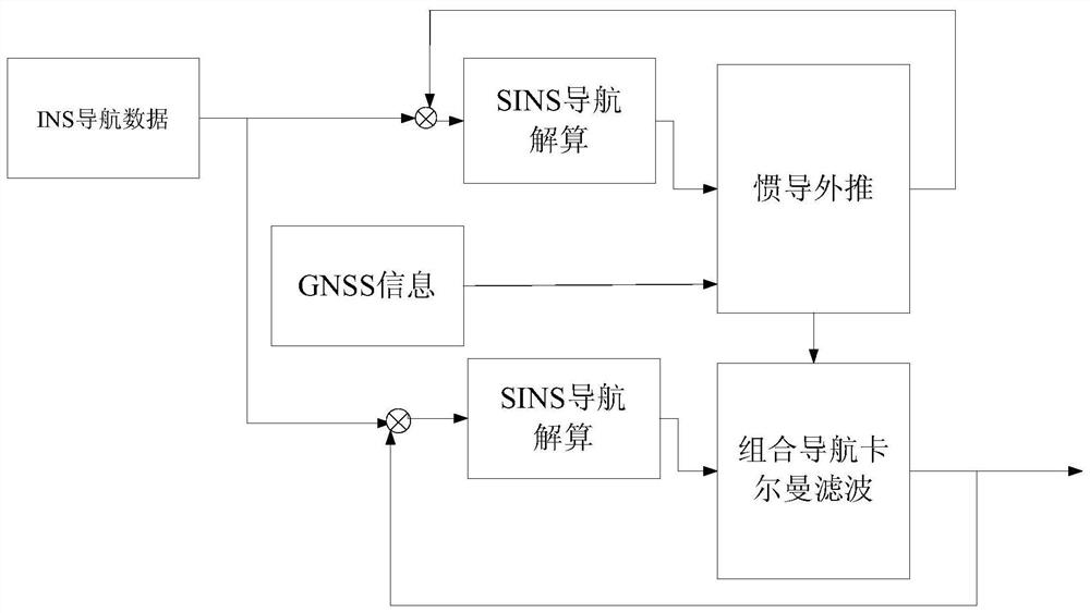
[0026] In order to achieve high-precision, real-time control navigation or attitude angle measurement of the aircraft, it is necessary to comprehensively process the position and speed information output by GNSS (Global Navigation Satellite System) and the speed and acceleration information output by INS (Inertial Navigation System). Computing, to achieve the complementary advantages of the two systems, to achieve continuous, all-weather, high-precision navigation, and then in terms of accuracy and reliability, it can obtain better performance than any single navigation device.

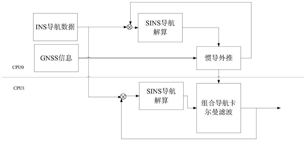
[0027] In order to realize real-time integrated navigation calculation, a high-precision real-time processing system is designed, which makes full use of dual CPU resources, can meet the strict performance requirements of real-time navigation calculation, and realize the purpose of accurate integrated navigation.

[0028] The present invention will be further described in detail below in conjunction wi...


PUM


Abstract

The invention relates to a high-precision real-time flight navigation calculation method, which comprises the following steps of receiving INS navigation data and GNSS information by using a high-speed processor, and then sequentially executing SINS navigation calculation, inertial navigation extrapolation, SINS navigation calculation and integrated navigation Kalman filtering. In a typical working scene of the method, the SINS navigation calculation is 0.5 ms, the extrapolation time of the GNSS to the SINS navigation is less than 0.01 ms, the extrapolation time can be ignored, the integratednavigation Kalman filtering is 1.6 ms, and the two navigation calculation inputs are different, so that the two navigation calculation inputs need to be operated independently. Therefore, the total consumed time is about 0.5*2+1.6=2.6 ms, 80% of time margin is considered, and the system real-time performance requirement that the integrated navigation calculation period is larger than 3.25 ms can be met. Double-CPU resources are fully utilized, strict real-time navigation calculation performance requirements can be met, and accurate integrated navigation can be achieved.

Description

technical field [0001] The invention relates to a high-precision real-time flight navigation calculation method, which belongs to the technical field of control navigation calculation and attitude measurement. Background technique [0002] GNSS (Global Satellite Navigation System) can measure position, speed and time, but it cannot provide stable and correct navigation information in the application scenarios where the aircraft’s working electromagnetic environment is complex or satellite signals are affected; INS (Inertial Navigation System) can realize position , speed and attitude measurement, but as a navigation method of integral calculation, there is an inherent defect that the error accumulates over time; and for the complex attitude movement of the spin vehicle, the performance of the INS sensor will be reduced. Contents of the invention [0003] The technical solution problem of the present invention is: overcome the deficiencies in the prior art, the present inve...

Claims


Application Information

Patent Timeline
Patent Type & Authority Applications(China)
IPC IPC(8): G01C21/20G01C21/16G01S19/47
CPCG01C21/20G01C21/165G01S19/47
Inventor 董春杨方海红王君鞠晓燕杨宇彭杰秦卓张瑞鹏苏峰孟晨光王菁华边梦琦程光耀窦宇飞付思帅凌咸庆李德标宋景亮王晨王东东王洁王玥兮张超张竑颉
Owner BEIJING AEROSPACE INST OF THE LONG MARCH VEHICLE
Why Eureka
Try Eureka