Unmanned aerial vehicle operation path planning method and device, unmanned aerial vehicle and medium

A path planning and drone technology, applied in the field of drones, can solve problems such as increasing the energy consumption of drones, increasing the non-operating distance of drones, and reducing the operating time and area of ​​drones.

Pending Publication Date: 2021-03-19
GUANGZHOU XAIRCRAFT TECH CO LTD
View PDF8 Cites 5 Cited by
  • Summary
  • Abstract
  • Description
  • Claims
  • Application Information

AI Technical Summary

Problems solved by technology

During this process, the UAV needs to fly along the boundary to bypass the concave point, thus causing the UAV to be in a non-operational state (that is, not spraying potions or fertilizers). The distance that the UAV flies in a non-operational state is called Non...

Method used


Image

  • Unmanned aerial vehicle operation path planning method and device, unmanned aerial vehicle and medium
  • Unmanned aerial vehicle operation path planning method and device, unmanned aerial vehicle and medium
  • Unmanned aerial vehicle operation path planning method and device, unmanned aerial vehicle and medium

Examples


Embodiment 1

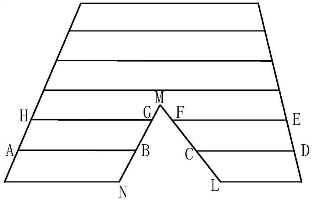
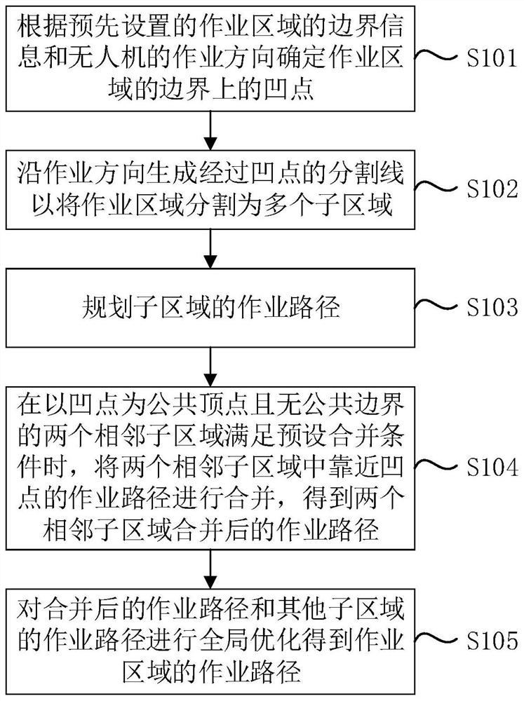
[0110] Figure 2A It is a flow chart of a UAV operation path planning method provided by Embodiment 1 of the present invention. This embodiment can be applied to the situation of planning an operation path when there are concave points on the boundary of the operation area. This method can be provided by the embodiment of the present invention. UAV operation path planning device, which can be implemented in the form of software and / or hardware, and integrated in the UAV, such as Figure 2A As shown, the method specifically includes the following steps:

[0111] S101. Determine the concave point on the boundary of the working area according to the preset boundary information of the working area and the working direction of the drone.

[0112] Wherein, the operation area may be an area where plant protection crops are planted, such as forest or farmland, etc., and the boundary of the operation area may be the boundary of forest or farmland. UAV operations can be plant protection...

Embodiment 2

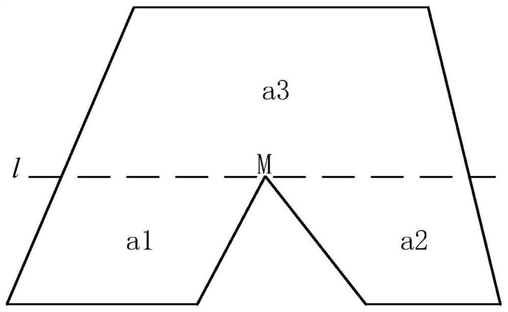
[0137] Figure 3A It is a flow chart of a UAV operation path planning method provided by Embodiment 2 of the present invention. The embodiment of the present invention is optimized on the basis of the foregoing Embodiment 1, and an exemplary implementation method of the present invention is described in detail. Specifically, as Figure 3A As shown, the method in the embodiment of the present invention may include the following steps:

[0138]S201. Determine the concave point on the boundary of the working area according to the preset boundary information of the working area and the working direction of the drone.

[0139] Specifically, the boundary information of the operation area can be determined in advance through manual surveying and mapping or by drone aerial photography, and the boundary information can be stored in a remote server or the local memory of the drone, and the boundary information can be called when needed. Wherein, the boundary information may include pos...

Embodiment 3

[0190] Embodiment 3 of the present invention provides a UAV operation path planning device, Figure 4 A schematic structural diagram of an unmanned aerial vehicle operation path planning device provided in Embodiment 4 of the present invention, as shown in Figure 4 As shown, the device may specifically include:

[0191] The concave point determination module 301 is used to determine the concave point on the boundary of the operation area according to the boundary information of the preset operation area and the operation direction of the drone;

[0192] An area segmentation module 302, configured to generate a dividing line passing through the concave point along the working direction to divide the working area into a plurality of sub-areas;

[0193] Path planning module 303, configured to plan the operation path of the sub-area;

[0194] A path merging module 304, configured to combine the two adjacent sub-areas close to the concave point when two adjacent sub-areas with t...


PUM


Abstract

The invention discloses an unmanned aerial vehicle operation path planning method and device, an unmanned aerial vehicle and a medium. The method comprises the steps of determining concave points on the boundary of an operation area, generating segmentation lines passing through the concave points in the operation direction so as to segment the operation area into a plurality of sub-areas, planning operation paths of the sub-areas, when it is determined that the two adjacent sub-areas taking the concave point as the common vertex and having no common boundary meet a preset merging condition, merging the operation paths close to the concave point in the two adjacent sub-areas, and performing global optimization on the merged operation paths and the operation paths of the other sub-areas toobtain the operation paths of the operation regions. The detour frequency and the steering frequency of the unmanned aerial vehicle when the unmanned aerial vehicle encounters the concave points are reduced, the non-operation distance and the steering of the unmanned aerial vehicle are reduced, the operation distance of the unmanned aerial vehicle is increased, the operable time and the operable area of the unmanned aerial vehicle are further increased, the number of globally optimized operation paths is reduced, the calculation amount is reduced, and the efficiency of obtaining the optimal operation path is improved.

Description

technical field [0001] The embodiments of the present invention relate to the technical field of unmanned aerial vehicles, and in particular to a method and device for planning an operation path of an unmanned aerial vehicle, an unmanned aerial vehicle and a medium. Background technique [0002] With the gradual maturity of UAV technology, UAVs have been widely used in many fields. For example, UAVs can perform flight operations such as surveying and mapping, plant protection, exploration, and aerial photography according to pre-planned routes. [0003] In the existing technology, UAVs can better plan the operation path for the operation area with regular boundaries to perform plant protection operations, but in actual plant protection operations, the boundaries of the operation area are often complex and irregular polygons, such as , there is a concave point on the boundary, and the two boundaries forming the concave point make the working area concave inward. For the oper...

Claims


Application Information

Patent Timeline
IPC IPC(8): G01C21/20
CPCG01C21/20
Inventor 叶凯杰朱俊星
Owner GUANGZHOU XAIRCRAFT TECH CO LTD
Why Eureka
Try Eureka