Cloud-containing remote sensing image compression method based on quantization strategy

A technology of remote sensing image and compression method, which is applied in the field of image processing, can solve problems such as the inability to retain thin cloud and ground object information, cloud area loss, etc., achieve the improvement of peak signal-to-noise ratio PSNR index, improve compression performance, and increase coding bit rate Effect

Active Publication Date: 2021-03-26
XIDIAN UNIV +1
View PDF3 Cites 0 Cited by
  • Summary
  • Abstract
  • Description
  • Claims
  • Application Information

AI Technical Summary

Problems solved by technology

However, these current preprocessing methods are all based on the filling strategy. During the filling process, all the information in the cloud area will be lost, and the ground object information under the thin cloud cannot be preserved, and it cannot strike a balance between the compression performance and the image restoration quality of the cloud area.

Method used


Image

  • Cloud-containing remote sensing image compression method based on quantization strategy
  • Cloud-containing remote sensing image compression method based on quantization strategy
  • Cloud-containing remote sensing image compression method based on quantization strategy

Examples


Embodiment Construction

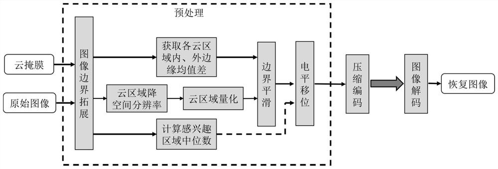
[0035] The specific embodiment of the present invention will be further described below in conjunction with accompanying drawing:

[0036] refer to figure 1 , the specific implementation steps of this example are as follows:

[0037] Step 1: Extend the boundaries of cloud-containing remote sensing images and cloud mask images.

[0038] 1.1) Note that the width of the original cloudy remote sensing image is W, the height is H, and the bit depth is Bd; the size of the original cloud mask image is consistent with the original cloudy remote sensing image;

[0039] 1.2) Boundary extension of cloudy remote sensing images:

[0040] If W is an odd number and H is an even number, add a column of data to the far right of the original cloud image, and the added data is the Wth column data of the original cloud image;

[0041] If W is an even number and H is an odd number, add a row of data at the bottom of the original cloud image, and the added data is the Hth row data of the origina...


PUM


Abstract

The invention discloses a cloud-containing remote sensing image compression method based on a quantization strategy, and mainly solves the problems that in the prior art, surface feature information of a thin cloud coverage area cannot be kept, and coding consumption is large. According to the scheme, the method comprises the steps: expanding the boundaries of a cloud-containing remote sensing image and a cloud mask image, and performing downsampling and interpolation on a cloud area; calculating an approximate median of a region of interest of the cloud-containing remote sensing image; obtaining gray masks marked with different cloud areas and gray images marked with inner and outer edges of the different cloud areas; quantizing the cloud area of the cloud-containing remote sensing imageaccording to the cloud mask image; carrying out boundary smoothing on the quantized image of the cloud area in combination with the gray images of the inner edge and the outer edge of the cloud area;subtracting a median from the values of all the pixel points in the smoothed image, performing compressed coding, and sending a code stream to a receiving end; and by the receiving end, decoding the code stream to obtain a recovered image. Coding consumption is reduced, information of a thin cloud coverage area can be partially reserved, and the method can be used for transmission of cloud-containing images.

Description

technical field [0001] The invention belongs to the technical field of image processing, and further relates to an efficient compression method for remote sensing images containing invalid cloud regions, which can be used for transmission and processing of various remote sensing images containing clouds. Background technique [0002] The rapid development of high-resolution remote sensing technology has intensified the contradiction between satellite-ground image transmission bandwidth and remote sensing image data volume. In order to transmit and process acquired images, fast and efficient data compression algorithms are needed. However, the ubiquitous cloud areas in remote sensing images occupy a large amount of storage space and transmission bandwidth, which reduces the data ROI of the region of interest, that is, the bandwidth utilization rate of the ground object area data in the image except the cloud area. Therefore, it is of great significance to study image compress...

Claims


Application Information

Patent Timeline
Patent Type & Authority Applications(China)
IPC IPC(8): H04N19/124H04N19/167H04N19/463
CPCH04N19/124H04N19/167H04N19/463
Inventor 王柯俨顾大卫李云松王旭升杨丽鋆张建华肖化超韩宇阎昆柴昱洲蒙红英
Owner XIDIAN UNIV
Why Eureka
Try Eureka