Water area shoreline pollution risk assessment method and control intelligent decision-making method and system
What is AI technical title?
AI technical title is built by PatSnap AI team. It summarizes the technical point description of the patent document.
A technology of risk assessment and water area, applied in the field of water area shoreline pollution risk assessment, can solve the problems of low efficiency of water area shoreline, low efficiency of control intelligent decision-making, low accuracy rate, etc.
Active Publication Date: 2021-04-16
HARBIN INST OF TECH
View PDF7 Cites 0 Cited by
Summary
Abstract
Description
Claims
Application Information
AI Technical Summary
This helps you quickly interpret patents by identifying the three key elements:
Problems solved by technology
Method used
Benefits of technology
Problems solved by technology
[0005] The present invention aims to solve the problem of low efficiency and low accuracy of the existing water area shoreline pollution risk assessment method, and the problem of low efficiency of corresponding control intelligent decision-making
Method used
Image
Click on the blue label to locate the original text in one second.
Reading with bidirectional positioning of images and text.
Examples
specific Embodiment approach 1
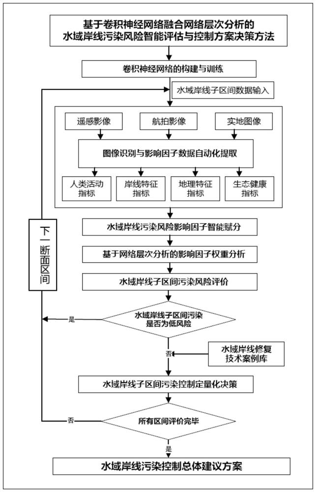
[0077] This embodiment is a water area shoreline pollution risk assessment method, including the following steps:
[0079] 1.1. Make three sample data sets of water coastline remote sensing images, aerial images and real images, and cut the water coastline remote sensing images, aerial images and real images into RGB three-channel images with a fixed size of 256*256*3. The absolute resolution is 0.13m / pixel, and artificially mark the constituent elements such as woodland, farmland, water body, buildings, and shoreline of the water coastline;
[0080] 1.2. Construct a fusion convolutional neural network based on InceptionV3 and attention mechanism for water coastline remote sensing images, aerial images and real images;
[0081] 1.3. For the shoreline remote sensing image, aerial image and real image of the water area, respectively set the type of model recognition, optimization target, number of iterations, use high-...
specific Embodiment approach 2
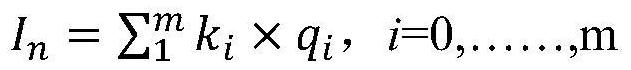
[0122] This embodiment is a water area shoreline pollution risk assessment method, according to the comprehensive index of water area shoreline pollution risk is I n The process of achieving a pollution risk assessment of the shoreline of a water body includes the following steps:
[0123] Water area shoreline pollution risk comprehensive index I n The value range is 0 to 4, and the score of the waters shoreline pollution risk comprehensive index is graded, when 0≤I n <2, the risk level of the section is low risk;
[0125] If 3≤I n <4, the coastline risk level of the section waters is high risk.
[0126] Other steps are the same as in the first embodiment.
specific Embodiment approach 3
[0128] This implementation mode is a water area shoreline pollution risk assessment system, and the system described in this implementation mode is used to implement the water area coastline pollution risk assessment method described in the first or second specific implementation mode.
technical field [0001] The invention relates to a water area shoreline pollution risk assessment method and a control intelligent decision-making method. It belongs to the intersection field of environmental engineering technology and computer technology. Background technique [0002] The shoreline of the water area is the general designation of the belt-shaped area within a certain range of the river and lake waters on the water and land boundary. Ecosystem service functions such as habitat and climate regulation play an important role in the development of urban economy and the construction of ecological civilization. However, with the development of my country's economy, problems such as illegal sewagedischarge, barrier building, fishing, breeding, sand mining, mining, reclamation, etc. encroaching on the shoreline of water areas are becoming more and more serious, which in turn leads to the deterioration of the water environment quality of rivers and lakes, and there a...
Claims
Application Information
Patent Timeline
Application Date:The date an application was filed.
Publication Date:The date a patent or application was officially published.
First Publication Date:The earliest publication date of a patent with the same application number.
Issue Date:Publication date of the patent grant document.
PCT Entry Date:The Entry date of PCT National Phase.
Estimated Expiry Date:The statutory expiry date of a patent right according to the Patent Law, and it is the longest term of protection that the patent right can achieve without the termination of the patent right due to other reasons(Term extension factor has been taken into account ).
Invalid Date:Actual expiry date is based on effective date or publication date of legal transaction data of invalid patent.

