Water area shoreline pollution risk assessment method and control intelligent decision-making method and system

A technology for risk assessment and water area, applied in the field of water area shoreline pollution risk assessment, can solve the problems of low efficiency of control intelligent decision-making, low efficiency of water area shoreline, low accuracy rate, etc., to achieve efficiency improvement, time-consuming solution, and strong applicability Effect

Active Publication Date: 2021-09-24
HARBIN INST OF TECH
View PDF0 Cites 0 Cited by
  • Summary
  • Abstract
  • Description
  • Claims
  • Application Information

AI Technical Summary

Problems solved by technology

[0005] The present invention aims to solve the problem of low efficiency and low accuracy of the existing water area shoreline pollution risk assessment method, and the problem of low efficiency of corresponding control intelligent decision-making

Method used


Image

  • Water area shoreline pollution risk assessment method and control intelligent decision-making method and system
  • Water area shoreline pollution risk assessment method and control intelligent decision-making method and system
  • Water area shoreline pollution risk assessment method and control intelligent decision-making method and system

Examples


specific Embodiment approach 1

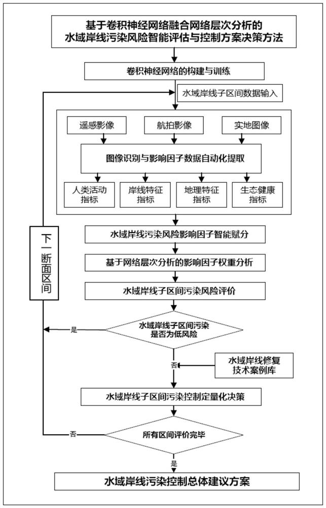
[0076] This embodiment is a water area shoreline pollution risk assessment method, including the following steps:

[0077] 1. Build and train a convolutional neural network:

[0078] 1.1. Make three sample data sets of water coastline remote sensing images, aerial images and real images, and cut the water coastline remote sensing images, aerial images and real images into RGB three-channel images with a fixed size of 256*256*3. The absolute resolution is 0.13m / pixel, and artificially mark the constituent elements such as woodland, farmland, water body, buildings, and shoreline of the water coastline;

[0079] 1.2. Construct a fusion convolutional neural network based on InceptionV3 and attention mechanism for water coastline remote sensing images, aerial images and real images;

[0080] 1.3. For the shoreline remote sensing image, aerial image and real image of the water area, respectively set the type of model recognition, optimization target, number of iterations, use high-...

specific Embodiment approach 2

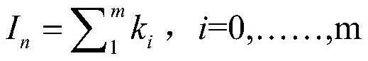
[0120] This embodiment is a water area shoreline pollution risk assessment method, according to the comprehensive index of water area shoreline pollution risk is I n The process of achieving a pollution risk assessment of the shoreline of a water body includes the following steps:

[0121] Water area shoreline pollution risk comprehensive index I n The value range is 0 to 4, and the score of the waters shoreline pollution risk comprehensive index is graded, when 0≤I n <2, the risk level of the section is low risk;

[0122] If 2≤I n <3, the coastline risk level of the section waters is medium risk;

[0123] If 3≤I n <4, the coastline risk level of the section waters is high risk.

[0124] Other steps are the same as in the first embodiment.

specific Embodiment approach 3

[0125] This implementation mode is a water area shoreline pollution risk assessment system, and the system described in this implementation mode is used to implement the water area coastline pollution risk assessment method described in the first or second specific implementation mode.


PUM


Abstract

The water area shoreline pollution risk assessment method and the control intelligent decision-making method and system belong to the interdisciplinary field of environmental engineering technology and computer technology. In order to solve the problems of low efficiency and low accuracy of existing shoreline pollution risk assessment methods in water areas, and the low efficiency of corresponding control intelligent decision-making. The present invention uses convolutional neural network to identify and semantically segment water coastline remote sensing images, aerial images, and regional images, and completes automatic calculation and assignment of image factors such as shoreline width, human activities, cultivated land occupation area, and dominant plants; the construction is based on The waters shoreline pollution risk evaluation system based on the network hierarchy analysis determines the weight of the impact factors, so as to obtain objective and fair quantitative evaluation results, and proposes a waters coastline pollution control strategy based on the weight of the impact factors. It is mainly used for water shoreline pollution risk assessment and control intelligent decision-making.

Description

technical field [0001] The invention relates to a water area shoreline pollution risk assessment method and a control intelligent decision-making method. It belongs to the intersection field of environmental engineering technology and computer technology. Background technique [0002] The shoreline of the water area is the general designation of the belt-shaped area within a certain range of the river and lake waters on the water and land boundary. Ecosystem service functions such as habitat and climate regulation play an important role in the development of urban economy and the construction of ecological civilization. However, with the development of my country's economy, problems such as illegal sewage discharge, barrier building, fishing, breeding, sand mining, mining, reclamation, etc. encroaching on the shoreline of water areas are becoming more and more serious, which in turn leads to the deterioration of the water environment quality of rivers and lakes, and there a...

Claims


Application Information

Patent Timeline
Patent Type & Authority Patents(China)
IPC IPC(8): G06Q10/06G06Q50/26G06K9/00G06K9/34G06K9/62G06N3/08G06N3/04
Inventor 李俐频张天奇张曦予田禹赵焱李明月
Owner HARBIN INST OF TECH
Why Eureka
Try Eureka