Closed-loop control aerial survey unmanned aerial vehicle

A technology of drones and control signals, applied in the field of aerial survey drones, can solve problems such as incomplete data and data processing errors, and achieve the effect of ensuring flight quality and avoiding incompleteness

Inactive Publication Date: 2021-04-30
广西翼界科技有限公司
View PDF2 Cites 0 Cited by
  • Summary
  • Abstract
  • Description
  • Claims
  • Application Information

AI Technical Summary

Problems solved by technology

However, if the camera does not read the signal or other reasons cause the camera not to be executed, the data will be incomplete, resulting in post-data processing errors

Method used


Image

  • Closed-loop control aerial survey unmanned aerial vehicle

Examples


Embodiment Construction

[0014] The present invention will be further described below in conjunction with accompanying drawing:

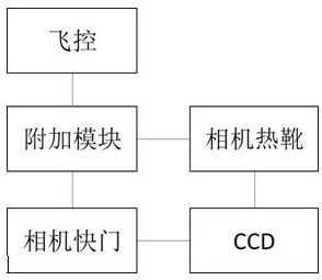
[0015] The aerial survey drone is equipped with a flight control system to make the drone fly stably according to the preset aerial photography route, and output aerial survey control signals at the aerial survey points in turn, and record the external orientation data of the current survey point at the same time.

[0016] Aerial survey UAVs obtain images by carrying cameras and continuously taking pictures. Light and compact optical cameras on the market can be used for aerial photography, and its cost is relatively low. The usual optical camera includes three parts: the shutter, which is used to control the execution of the photo taking action, and the shutter interface is generally set to connect the control input; the CCD, which obtains image data through exposure; the hot shoe, which is the interface for external flashlights and other components.

[0017] This case is...


PUM


Abstract

The invention discloses a closed-loop control aerial survey unmanned aerial vehicle which is provided with a flight control system and a camera, the flight control system records exterior orientation data, and the camera executes image acquisition. The unmanned aerial vehicle is further provided with an additional module, the additional module is connected between the flight control system and the camera, the camera is controlled to execute image acquisition while the flight control system records exterior orientation data, it is guaranteed that orientation data correspond to images, and measuring point data incompleteness is avoided.

Description

technical field [0001] The invention relates to a closed-loop controlled aerial survey unmanned aerial vehicle, which belongs to the technical field of aerial survey equipment. Background technique [0002] UAV aerial surveys must simultaneously acquire images and corresponding external orientation data, including three-axis attitude, position coordinates, etc., to provide basic data for later image correction, fusion, and splicing. [0003] In the prior art, the aerial survey image is obtained by taking photos with the camera carried by the UAV, and the external orientation data is provided by the airborne flight controller. While the flight controller outputs the camera control signal, it extracts the external orientation data for storage and recording. However, if the camera does not read the signal or other reasons cause the camera not to be executed, the data will be incomplete, resulting in post-data processing errors. [0004] UAV flight safety depends on the stabil...

Claims


Application Information

Patent Timeline
Patent Type & Authority Applications(China)
IPC IPC(8): G01C11/08G05D1/10
CPCG01C11/08G05D1/101
Inventor 吴东乔尹宝新
Owner 广西翼界科技有限公司
Why Eureka
Try Eureka