Navigation and sensor fused path pushing method and system and storage medium

A sensor and sensor module technology, applied in navigation, surveying and mapping and navigation, road network navigator, etc., can solve the problem of unreal-time and inaccurate route push, and achieve the effect of improving driving safety and experience

Pending Publication Date: 2021-05-04
CHONGQING CHANGAN AUTOMOBILE CO LTD
View PDF0 Cites 4 Cited by
  • Summary
  • Abstract
  • Description
  • Claims
  • Application Information

AI Technical Summary

Problems solved by technology

Now there are various route push methods, but for areas with insufficient navigation s

Method used


Image

  • Navigation and sensor fused path pushing method and system and storage medium
  • Navigation and sensor fused path pushing method and system and storage medium
  • Navigation and sensor fused path pushing method and system and storage medium

Examples


Embodiment Construction

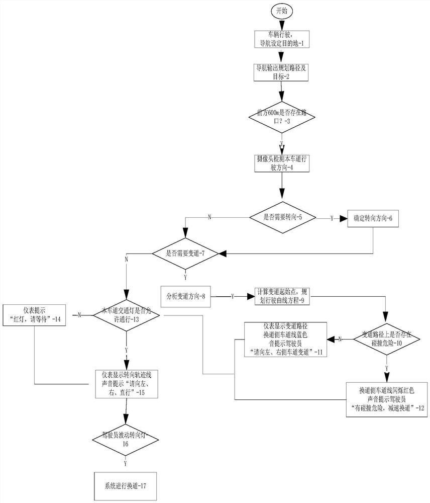
[0040] Below in conjunction with accompanying drawing, the present invention is further described:

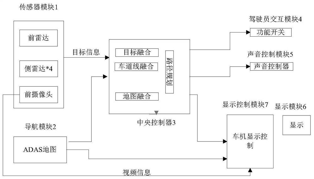
[0041] see figure 1 , the present invention can adopt the illustrated system framework, including sensor module 1, navigation module 2, central controller 3, driver interaction module 4, voice control module 5, display control module 7 and display module 6, etc.

[0042] The present invention judges the navigation path through the millimeter-wave radar, intelligent front camera, panoramic camera and ADAS map, and provides the navigation path through the instrument navigation module, and the millimeter-wave radar, camera, and panoramic camera detect the real-time situation of the traffic environment and participants, Correct the navigation path to avoid situations such as taking the wrong lane, running traffic lights, and radical steering under the guidance of navigation.

[0043] In this embodiment, the sensor module 1 includes a forward millimeter wave radar, four side millim...


PUM


Abstract

The invention discloses a navigation and sensor fused path pushing method and system and a storage medium, which are used for monitoring road information and planning a navigation path in real time through fusion of a map and a sensor, performing scene reconstruction on an environment and a path through an instrument, and providing real-time and accurate path planning for a driver. Specifically, the lane where the vehicle is located is determined according to camera information, whether lane changing is needed or not is determined in combination with navigation, and navigation is more accurate compared with traditional navigation; the lane changing time and path are determined according to fusion information of the radar and the camera, and the situations of collision danger, red light running, intersection missing and the like are avoided; panoramic camera information is fused, the problems of jam and side collision under the congested road condition are solved, and the driving safety and experience feeling are improved; navigation is fused with video information, so that the path is clearer.

Description

technical field [0001] The invention belongs to the field of safe driving of automobiles, and in particular relates to vehicle navigation path planning technology. Background technique [0002] At present, on-board navigation has become the standard configuration of the vehicle, but now the navigation mainly provides the route and prompt information of the standard working condition. Traffic light conditions, lane lines, and real-time traffic flow conditions are not clear, and it is easy to turn with navigation under red light conditions, change lanes when there is congestion, and long solid lines cannot change lanes. With the increasing popularity of driving assistance technology, more and more vehicles are equipped with ADAS maps, which are mainly used to provide lane types, speed limits and lane line recognition. Now there are various route push methods, but for areas with insufficient navigation signals, there is still the problem that the route push is not real-time an...

Claims


Application Information

Patent Timeline
IPC IPC(8): G01C21/34G01C21/36
CPCG01C21/3415G01C21/3492G01C21/36
Inventor 凌洪清卢斌孟璋劼
Owner CHONGQING CHANGAN AUTOMOBILE CO LTD
Why Eureka
Try Eureka