Water conservancy and hydropower engineering multi-source data fusion method based on BIM+GIS

A multi-source data and fusion method technology, applied in data processing applications, special data processing applications, instruments, etc., can solve problems such as different encoding methods, large amount of model data, and inconsistent model data formats, and achieve strong practicability, The effect of high system availability

Pending Publication Date: 2021-05-07
YELLOW RIVER ENG CONSULTING
View PDF0 Cites 5 Cited by
  • Summary
  • Abstract
  • Description
  • Claims
  • Application Information

AI Technical Summary

Problems solved by technology

However, the current problems of this technology in the industry mainly include: 1. Large amount of model data: the BIM model of data fusion is often a design model established by the design unit and a construction deepening model established by the construction unit, and the data of these two models is too complicated , The volume is too large, which often leads to distortion of the fused model or system operation freeze
2. Diversification of model data sources: In the process of project implementation, the construction parties of the project usually use different data to create platforms, resulting in the BIM+GIS of the project management platform finally built by the project, and the model data format in a picture scene Not uniform, different encoding methods

Method used


Image

  • Water conservancy and hydropower engineering multi-source data fusion method based on BIM+GIS
  • Water conservancy and hydropower engineering multi-source data fusion method based on BIM+GIS

Examples


Embodiment Construction

[0065] The embodiments of the present invention will be described in detail below in conjunction with the accompanying drawings. This embodiment is implemented on the premise of the technical solution of the present invention, and detailed implementation methods and specific operating procedures are provided, but the scope of protection of the present invention is not limited to the following Described embodiment.

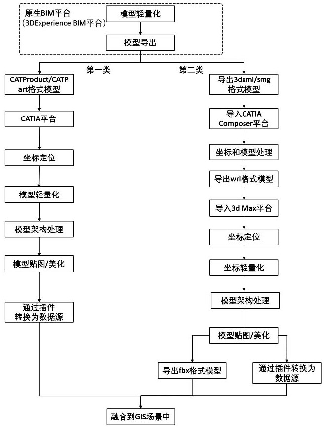
[0066] like figure 1 As shown, the multi-source data fusion method of water conservancy and hydropower projects based on BIM+GIS described in the present invention is carried out according to the following steps:

[0067] S1, since the native BIM platform (3DExperience BIM platform) model is directly imported into the GIS platform and lacks key information such as textures and attributes, it needs to be imported into a third-party platform for transfer processing before fusion; in the native BIM platform (3DExperience BIM platform) Export the fused model for light...


PUM


Abstract

The invention discloses a water conservancy and hydropower engineering multi-source data fusion method based on BIM+GIS. The method comprises the steps of S1, exporting a fused model in a native BIM platform for lightweight processing; S2, fusing two types of multi-source model data; and S3, acquiring, processing and fusing oblique photography data in GIS software. The invention provides a technical scheme for processing, importing and keeping the model light weight, high quality and high system availability based on the native BIM platform model, and solves the problems that the BIM visualization platform model is large in volume and slow in platform loading; and the technical scheme of data acquisition, fusion and application of oblique photography data from field surveying and mapping, data processing and data fusion is verified.

Description

technical field [0001] The invention relates to a water conservancy and hydropower project management "digital twin" scenario, in particular to a BIM+GIS-based multi-source data fusion method for water conservancy and hydropower projects. Background technique [0002] As the basis of engineering intelligence, BIM+GIS technology is increasingly used in point-shaped and long-term water conservancy and hydropower engineering projects. However, BIM+GIS technology needs to integrate BIM model, oblique photography data, terrain data, orthophoto data, GIS coordinate data and other multi-source data in the same scene to create a "digital twin" scene that is close to reality for the project. However, the current problems of this technology in the industry mainly include: 1. Large amount of model data: the BIM model of data fusion is often a design model established by the design unit and a construction deepening model established by the construction unit, and the data of these two mo...

Claims


Application Information

Patent Timeline
IPC IPC(8): G06F30/13G06K9/62G06Q50/08
CPCG06F30/13G06Q50/08G06F18/251Y04S10/50
Inventor 尤林奇王楠陶玉波蔺志刚王陆张钧睿王小平李彦刘瑾程贺逸清
Owner YELLOW RIVER ENG CONSULTING
Why Eureka
Try Eureka