Novel inclinometry north-seeking resolving method

A technology of inclination measurement and calculation, which is used in measurement devices, mapping and navigation, and speed measurement by gyro effect.

Active Publication Date: 2021-05-11
上海威领信息科技有限公司
View PDF5 Cites 0 Cited by
  • Summary
  • Abstract
  • Description
  • Claims
  • Application Information

AI Technical Summary

Problems solved by technology

[0004] The purpose of the present invention is to provide a novel method for calculating north-seeking inclination surveying, to solve the existing test method proposed in the above-mentioned background technology. Due to the large range of ambient temperature changes in logging applications, this will restrict the use of north-seeking in non-horizontal planes. The problem of accuracy over the full temperature range

Method used


Image

  • Novel inclinometry north-seeking resolving method
  • Novel inclinometry north-seeking resolving method
  • Novel inclinometry north-seeking resolving method

Examples


Embodiment

[0045] see Figure 1-7 , the present invention provides a technical solution: a novel method for calculating north-seeking inclination, the specific method of calculating north-finding for inclination surveying is as follows:

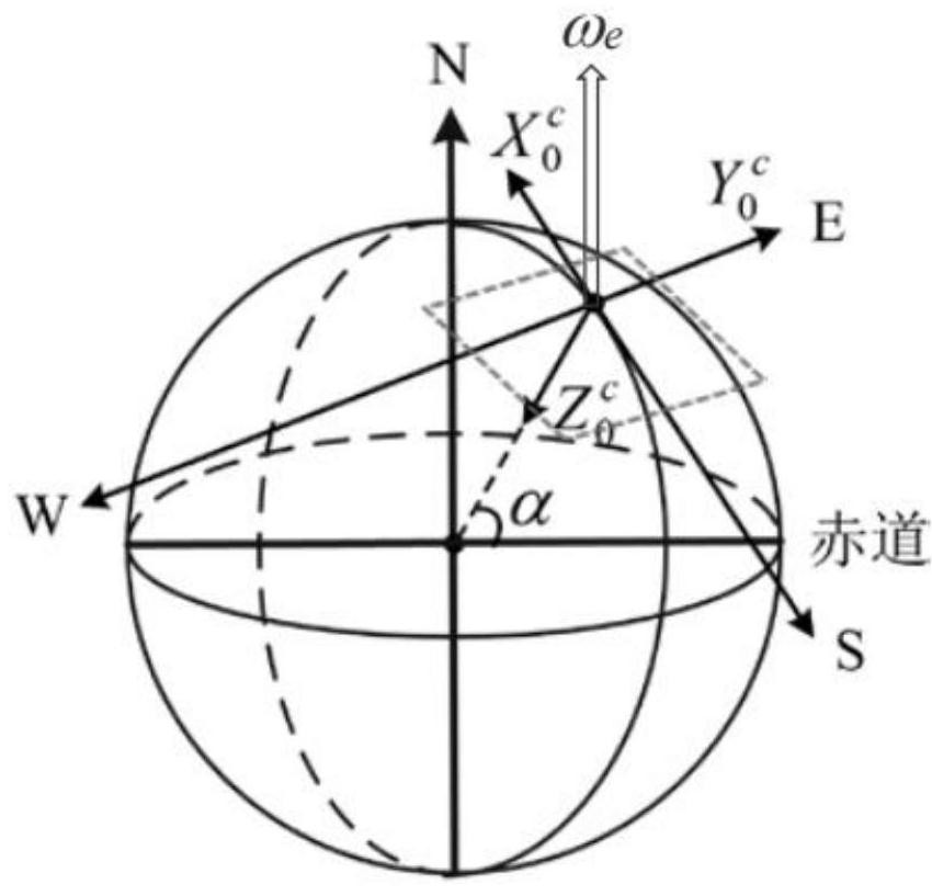
[0046] Such as figure 1 Shown in geographic coordinate system OX 0 c Y 0 c Z 0 c (Northeast), α is the geographic latitude of the measuring point. In a geographic coordinate system, the acceleration due to gravity g 0 and the earth's rotation angular velocity ω 0 for

[0047]

[0048] Among them, ω e is the angular rate of the earth's rotation, and g is the acceleration rate of the earth's gravity.

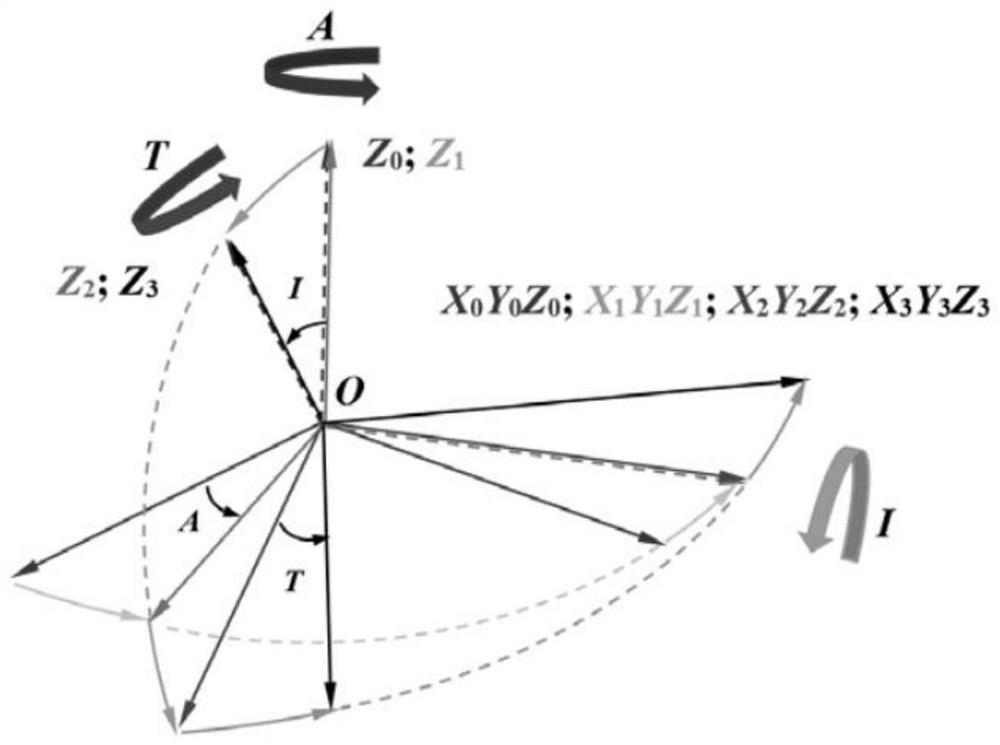
[0049] Such as figure 2Shown is a schematic diagram of the transformation between the geographic coordinate system and the carrier coordinate system. The geographic coordinate system is rotated three times to obtain the carrier coordinate system. The specified rotation direction is: from the positive direction of the rotation axis to the neg...


PUM


Abstract

The invention belongs to the technical field of well drilling, and particularly relates to a novel inclinometry north-seeking resolving method, which comprises the following specific mode that in a carrier coordinate system OX3cY3cZ3c, the vector of gravitational acceleration and the vector of earth rotation angular velocity are g3 = C03g0 and omega3 = C03omega0, wherein the resolving method only depends on the condition that in a single-time measurement adopting time, the relative relationship between the omega x and the omega y is irrelevant to the specific numerical values omega x and omega y, namely irrelevant to the scale factor s of the gyroscope. According to the scheme, the north-seeking error generated by the temperature characteristic of the scale factor can be eliminated, so that the resolving precision of the azimuth angle is improved, the calculation precision of the azimuth angle can be effectively improved, the method is effective for all non-horizontal-plane north-seeking applications, and the north-seeking error caused by the temperature characteristic of the scale factor is effectively inhibited.

Description

technical field [0001] The invention relates to the technical field of drilling, in particular to a novel north-finding and calculating method for inclination measurement. Background technique [0002] At present, there are two main types of drilling inclinometers in the drilling system [1-4]: one is to use the fluxgate as an azimuth sensor to convert the earth's geographical azimuth by measuring the direction of the earth's magnetic field, so as to determine the wellbore trajectory towards. This measurement method requires that there is no ferromagnetic material within 5 meters around the fluxgate. The second type uses gyroscopes and accelerometers as measuring elements [5-7], and calculates the azimuth angle, inclination angle, and tool face angle by measuring the earth's rotation angular velocity and gravitational acceleration, so as to determine the wellbore trajectory. Because the gyroscope is not affected by the external magnetic field, it is suitable for measuring t...

Claims


Application Information

Patent Timeline
Patent Type & Authority Applications(China)
IPC IPC(8): G01C19/00G01C19/72
CPCG01C19/00G01C19/72Y02A90/30
Inventor 王子宇伍刚王心悦何昌洪万放伍佑明谢丽芳
Owner 上海威领信息科技有限公司
Why Eureka
Try Eureka