Vehicle positioning method, device and equipment and storage medium

A positioning method and vehicle technology, which is applied to measuring devices, instruments, surveying and navigation, etc., can solve problems such as difficulty in ensuring software security, difficulty in ensuring communication stability, and easy interference in communication, so as to avoid real-time communication and simplify Calculation complexity, the effect of reducing communication pressure

Active Publication Date: 2021-05-14
北京星云互联科技有限公司
View PDF9 Cites 2 Cited by
  • Summary
  • Abstract
  • Description
  • Claims
  • Application Information

AI Technical Summary

Problems solved by technology

[0003] For vehicle positioning, it is usually realized through the Internet of Vehicles platform, or with the help of installed third-party positioning software (such as navigation software); however, obtaining positioning information through the Internet of Vehicles platform requires the vehicle to maintain real-time remote communication with the Internet of Vehicles platform, This places extremely high requirements on the communication bandwidth of the vehicle terminal equipment. At the same time, the communication between the vehicle and the Internet of Vehicles platform is restricted by environmental factors, and it is difficult to ensure the stability of the communication; and with the help of third-party positioning software, there is also the possibility that the communication is easily interfered. In addition, the third-party software itself also has certain security risks, and the security of the software is difficult to be guaranteed.

Method used


Image

  • Vehicle positioning method, device and equipment and storage medium
  • Vehicle positioning method, device and equipment and storage medium
  • Vehicle positioning method, device and equipment and storage medium

Examples


Embodiment 1

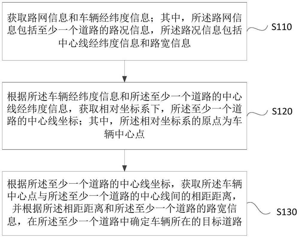
[0028] Figure 1A It is a flow chart of a vehicle positioning method provided in Embodiment 1 of the present invention. This embodiment is applicable to determine the road where the vehicle is located based on road network information and vehicle latitude and longitude information. This method can be determined by the vehicle in the embodiment of the present invention. positioning device, the device can be implemented by software and / or hardware, and integrated in the vehicle-mounted terminal device or server, the method specifically includes the following steps:

[0029] S110. Acquire road network information and vehicle latitude and longitude information; wherein, the road network information includes road condition information of at least one road, and the road condition information includes centerline latitude and longitude information and road width information.

[0030] Road Network (Road Network) is an interconnected road system composed of various roads in a certain are...

Embodiment 2

[0047] figure 2 It is a flow chart of a vehicle positioning method provided by Embodiment 2 of the present invention. This embodiment is embodied on the basis of the above-mentioned technical solution. In this embodiment, the road segment information of all road segments in the target road is obtained. The methods specifically include:

[0048] S210. Acquire road network information and vehicle latitude and longitude information; wherein, the road network information includes road condition information of at least one road, and the road condition information includes centerline latitude and longitude information and road width information.

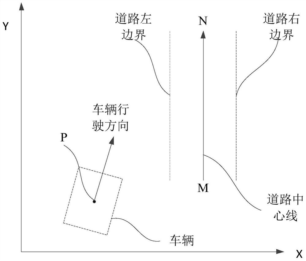
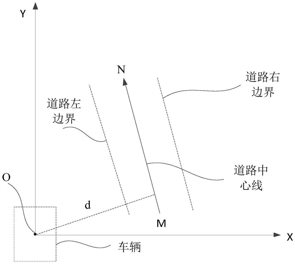
[0049] S220. Acquire the centerline coordinates of the at least one road in a relative coordinate system according to the latitude and longitude information of the vehicle and the latitude and longitude information of the centerline of the at least one road; wherein, the origin of the relative coordinate system is the center point of the ...

Embodiment 3

[0059] image 3 It is a structural block diagram of a vehicle positioning device provided in Embodiment 3 of the present invention, and the device specifically includes: an information acquisition module 310, a centerline coordinate acquisition module 320, and a test data generation module 230;

[0060] An information acquisition module 310, configured to acquire road network information and vehicle latitude and longitude information; wherein, the road network information includes road condition information of at least one road, and the road condition information includes centerline latitude and longitude information and road width information;

[0061] The centerline coordinate acquisition module 320 is configured to acquire the centerline coordinates of the at least one road in a relative coordinate system according to the latitude and longitude information of the vehicle and the latitude and longitude information of the at least one road centerline; wherein, the relative coo...


PUM


Abstract

The embodiment of the invention discloses a vehicle positioning method and device, equipment and a storage medium. The method comprises the steps: acquiring road network information and vehicle longitude and latitude information; according to the longitude and latitude information of the vehicle and the longitude and latitude information of the center line of the at least one road, obtaining the coordinates of the center line of the at least one road in a relative coordinate system; and according to the center line coordinates of the at least one road, ingeniously converting a coordinate system into a relative coordinate system relative to the center position of the vehicle based on the vehicle position coordinates, simplifying the calculation complexity of calculating the distance between the center point of the vehicle and the center line of the at least one road, and determining a target road where the vehicle is located in the at least one road according to the distance and the road width information of the at least one road. According to the technical scheme disclosed by the embodiment of the invention, the road positioning of the vehicle is realized, the communication pressure of the vehicle is reduced, and the safety of the vehicle-mounted terminal equipment is improved.

Description

technical field [0001] Embodiments of the present invention relate to the technical field of automobiles, and in particular to a vehicle positioning method, device, vehicle-mounted terminal equipment, and storage medium. Background technique [0002] With the continuous advancement of science and technology, automobiles are developing in the direction of intelligence, and among them, the positioning technology of automobiles has become an important research direction in the field of automobiles. [0003] For vehicle positioning, it is usually realized through the Internet of Vehicles platform, or with the help of installed third-party positioning software (such as navigation software); however, obtaining positioning information through the Internet of Vehicles platform requires the vehicle to maintain real-time remote communication with the Internet of Vehicles platform. This places extremely high requirements on the communication bandwidth of the vehicle terminal equipment....

Claims


Application Information

Patent Timeline
Patent Type & Authority Applications(China)
IPC IPC(8): G01C21/34
CPCG01C21/3415
Inventor 王易之李明明王吟松赵晨
Owner 北京星云互联科技有限公司
Why Eureka
Try Eureka