Device and method for realizing real-time positioning and mapping

A real-time positioning and pose technology, applied in 3D modeling, image enhancement, image analysis, etc., can solve the problems of tracking accuracy decline, achieve the effects of reducing cumulative errors, improving positioning accuracy, and improving computing efficiency

Pending Publication Date: 2021-05-14
BEIJING SAMSUNG TELECOM R&D CENT +1
View PDF0 Cites 4 Cited by
  • Summary
  • Abstract
  • Description
  • Claims
  • Application Information

AI Technical Summary

Problems solved by technology

Many vision-based SLAM technology front-ends will use feature point extraction and feature point matching to initially track the position of the camera, but in some scenes with relatively poor textures (such as glass rooms, rooms with more white walls), it is possible to extract and match Fewer feature points will reduce the tracking accuracy and cause a large drift error

Method used


Image

  • Device and method for realizing real-time positioning and mapping
  • Device and method for realizing real-time positioning and mapping
  • Device and method for realizing real-time positioning and mapping

Examples


Embodiment Construction

[0049] In order to enable those skilled in the art to better understand the present invention, exemplary embodiments of the present invention will be described in further detail below in conjunction with the accompanying drawings and specific implementation methods.

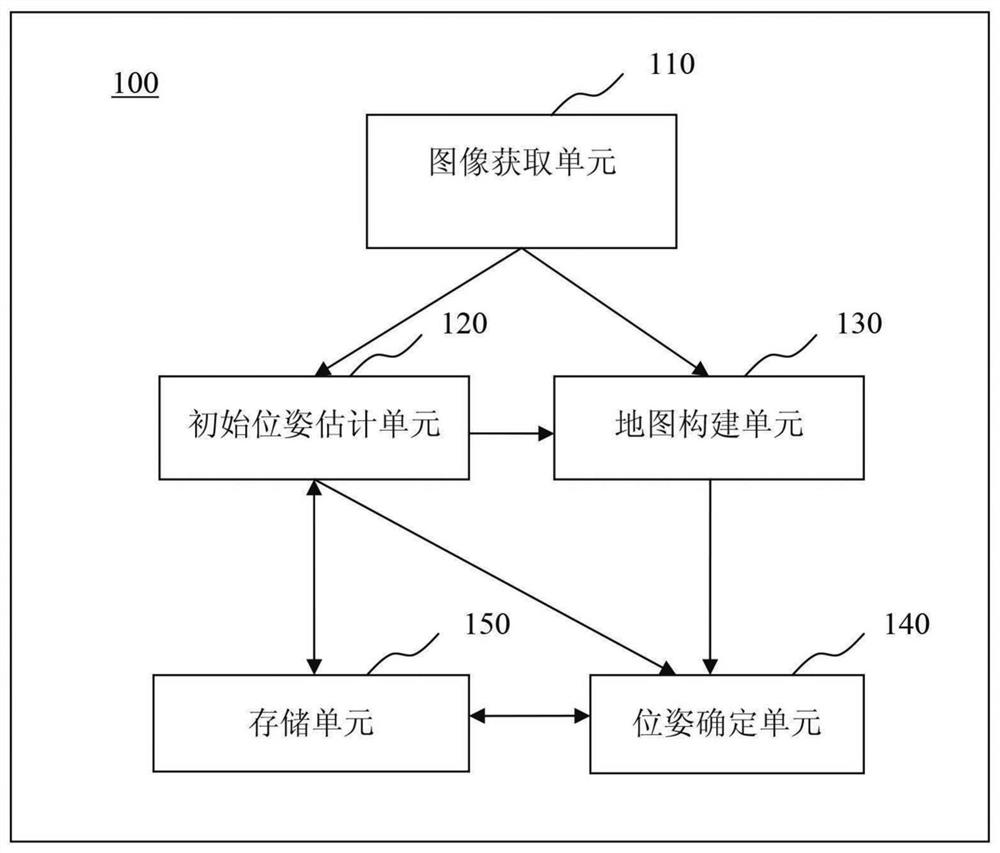
[0050] figure 1 is a block diagram illustrating a SLAM system 100 based on map reconstruction according to an exemplary embodiment of the present invention.

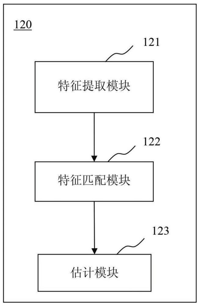
[0051] refer to figure 1 The SLAM system 100 based on map reconstruction (hereinafter referred to as "SLAM system 100") includes an image acquisition unit 110, an initial pose estimation unit 120, a map construction unit 130, a pose determination unit 140, and a storage unit 150.

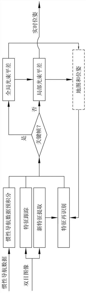
[0052] The image acquiring unit 110 can acquire the color image and the depth image of the surrounding environment where the SLAM system 100 is currently located as the color image and the depth image of the current frame to be processed. In addition, the “previous frame” menti...


PUM


Abstract

The invention provides a device and a method for realizing real-time positioning and mapping. The implementation device comprises an image acquisition unit which is configured to acquire a color image and a depth image of a surrounding environment; an initial pose estimation unit configured to estimate an initial pose based on the color image and the depth image; a map construction unit configured to construct a three-dimensional map based on the depth image and the color image; and the pose determination unit is configured to determine a final pose based on the initial pose and the three-dimensional map.

Description

technical field [0001] The present application relates to the field of real-time localization and mapping (SLAM), and more specifically, relates to a device and method for implementing SLAM based on reconstructed maps. Background technique [0002] In the method of constructing a three-dimensional map in the prior art, sensing devices such as cameras, laser sensors, and inertial measuring instruments installed on the equipment are usually used to obtain information about the surrounding environment in real time, thereby constructing a three-dimensional map of the surrounding environment. map, and output the position and attitude information of the device in the world coordinate system in real time. This technology is called real-time localization and mapping (SLAM, Simultaneous Localization And Mapping). [0003] Almost all SLAM systems are based on two frameworks: one is nonlinear optimization and the other is statistical filtering. According to different hardware sensing ...

Claims


Application Information

Patent Timeline
Patent Type & Authority Applications(China)
IPC IPC(8): G06T7/73G06T17/05G06T7/55
CPCG06T17/05G06T2207/10024G06T7/55G06T7/74G06T11/20G06T2207/10028G06T7/11G06T7/246G06T7/593G06T7/70G06T7/97
Inventor 史晓龙高天豪彭雄峰马宽刘志花王强金允泰全明帝李洪硕
Owner BEIJING SAMSUNG TELECOM R&D CENT
Why Eureka
Try Eureka