Multi-load remote sensing image-based rice yield estimation method for cloudy and rainy regions

A remote sensing image and multi-payload technology, applied in image enhancement, image analysis, image data processing, etc., can solve problems such as inability to meet high-precision requirements

Active Publication Date: 2021-05-18
成都四象纵横遥感科技有限公司
View PDF5 Cites 2 Cited by
  • Summary
  • Abstract
  • Description
  • Claims
  • Application Information

AI Technical Summary

Problems solved by technology

[0006] The purpose of the present invention is to provide a rice paddy plant based on multi-load remote sensing images for cloudy and rainy areas, aiming at the problem that current single optical re...

Method used


Image

  • Multi-load remote sensing image-based rice yield estimation method for cloudy and rainy regions

Examples


Embodiment 1

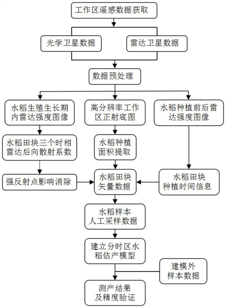
[0036] see figure 1 , a rice yield estimation method based on multi-load remote sensing images for cloudy and rainy areas, including the following steps:

[0037]Step 1: For a rice planting area, use optical remote sensing satellites and synthetic aperture radar remote sensing satellites to monitor a certain work area, obtain several monitoring images, and preprocess each image separately; and make a high-resolution ortho base map of the planting area .

[0038] Considering the characteristics of satellite remote sensing data, monitoring requirements and data costs, reasonably select remote sensing data sources covering the working area. Remote sensing data sources include high-resolution optical remote sensing data and synthetic aperture radar data. It is required that optical remote sensing can cover The monitoring area, and the high-resolution optical satellite quality is good, the image is clear, there is no cloud cover in the rice field area, and the resolution is better...

Embodiment 2

[0060] Taking the 2020 rice income insurance project in a certain place in Sichuan as an example, a rice yield estimation method based on multi-load remote sensing images for cloudy and rainy areas provided by the present invention will be described below.

[0061] According to the overall requirements and technical indicators of the project, collect basic data, mainly including high-resolution optical remote sensing data, multi-temporal radar data and related data, and perform data preprocessing.

[0062] Using the Jilin-1 optical remote sensing data to generate an orthographic base map of the remote sensing image of the work area with a resolution better than 1M, based on this, the rice planting area was extracted by computer classification in the ENVI software, and the rice planting area was manually interpreted and delineated in the ArcGIS software The boundary, get the vector data of the rice field, and add the relevant attribute information in the attribute table; use the...


PUM


Abstract

The invention discloses a multi-load remote sensing image-based rice yield estimation method for cloudy and rainy areas, and belongs to the field of remote sensing image agricultural application. The method includes: using an optical remote sensing satellite and a synthetic aperture radar remote sensing satellite to monitor a certain rice planting area; then, extracting a rice planting area of a working area by utilizing a GIS technology, and storing related information in an attribute table; then distinguishing the rice planting time; then calculating a radar backscattering coefficient Mean RSC corresponding to each field parcel; correcting a rice field area value influenced by the strong reflection point; carrying out manual sampling and yield measurement on the field to obtain the measured acre yield of the rice in the field; establishing a rice yield estimation model; and finally, calculating the estimated yield of the field according to the yield estimation model and the time-phase radar backscattering coefficient. The practical application problem of rice yield estimation in cloudy and rainy areas is solved.

Description

technical field [0001] The invention relates to the agricultural application field of remote sensing images, in particular to a rice production estimation method based on multi-load remote sensing images for cloudy and rainy areas. Background technique [0002] Rice occupies an important position in my country's grain production and is one of the important grain crops in my country. The planting area accounts for about 25% of the total grain sown area in the country, and its output reaches 32% of the total grain output in the country. The rice planting area and yield forecast is one of the important agricultural information, which is of great significance to the early warning of national food security and macroeconomic decision-making of grain. [0003] The traditional rice yield estimation adopts the method of manual regional survey, combined with agronomy, meteorology, and statistics, to establish crop yield estimation models from different angles. This method is slow, hea...

Claims


Application Information

Patent Timeline
IPC IPC(8): G06T7/136G06T7/62
CPCG06T2207/10044G06T2207/20132G06T2207/30188G06T7/136G06T7/62
Inventor 侯从强俞雷张薇姚勇航郑勇
Owner 成都四象纵横遥感科技有限公司
Why Eureka
Try Eureka