Transmission tower site selection optimization system and method based on satellite remote sensing recognition

A transmission tower, satellite remote sensing technology, applied in the direction of information technology support systems, instruments, data processing applications, etc., can solve the complex number of types of ground facilities, unstable geological structure, affecting the development speed of power grid construction, etc.

Pending Publication Date: 2021-05-28
YUNNAN POWER GRID CO LTD ELECTRIC POWER RES INST
View PDF6 Cites 1 Cited by
  • Summary
  • Abstract
  • Description
  • Claims
  • Application Information

AI Technical Summary

Problems solved by technology

[0004] However, in the actual grid line planning, due to the large number of existing grid lines, complex types and large numbers of ground facilities, and because the grid lines span a large range, there are often certain natural areas along the way, especially the need to avoid open natural areas, e.g., geologically unstable, or pristine geological areas requiring strict environmental protection
[0005] On this basis, using the method of manually planning power grid lines often requires a lot of wasted manpower and material resources for on-site surveys. The planning cycle of power grid lines is long, resulting in low efficiency of power grid line planning and affecting the development speed of power grid construction.

Method used


Image

  • Transmission tower site selection optimization system and method based on satellite remote sensing recognition
  • Transmission tower site selection optimization system and method based on satellite remote sensing recognition
  • Transmission tower site selection optimization system and method based on satellite remote sensing recognition

Examples


Embodiment Construction

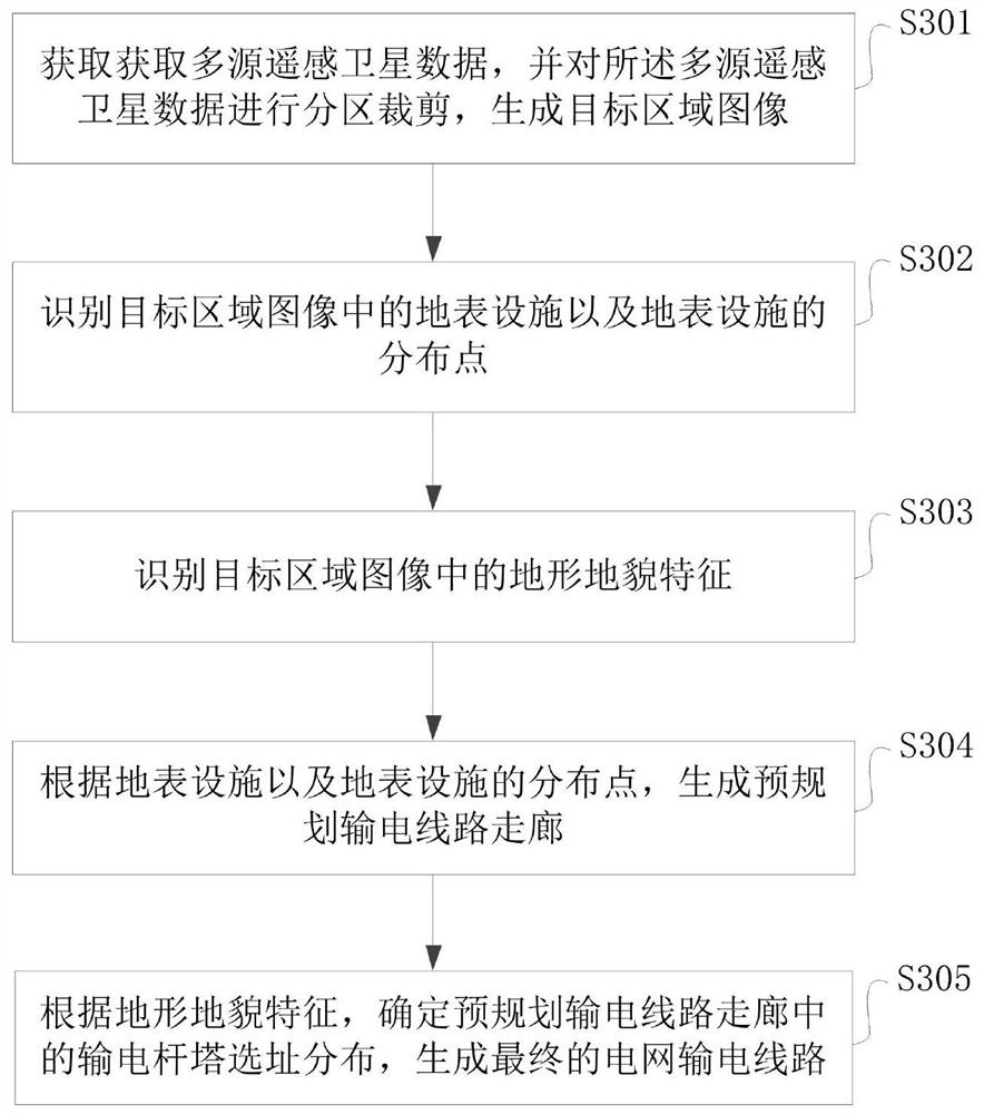
[0042] In order to shorten the power grid line planning cycle, improve the efficiency of power grid line planning, and accelerate the development of power grid construction, the embodiment of the present application provides a system and method for optimizing the site selection of power transmission towers based on satellite remote sensing recognition.

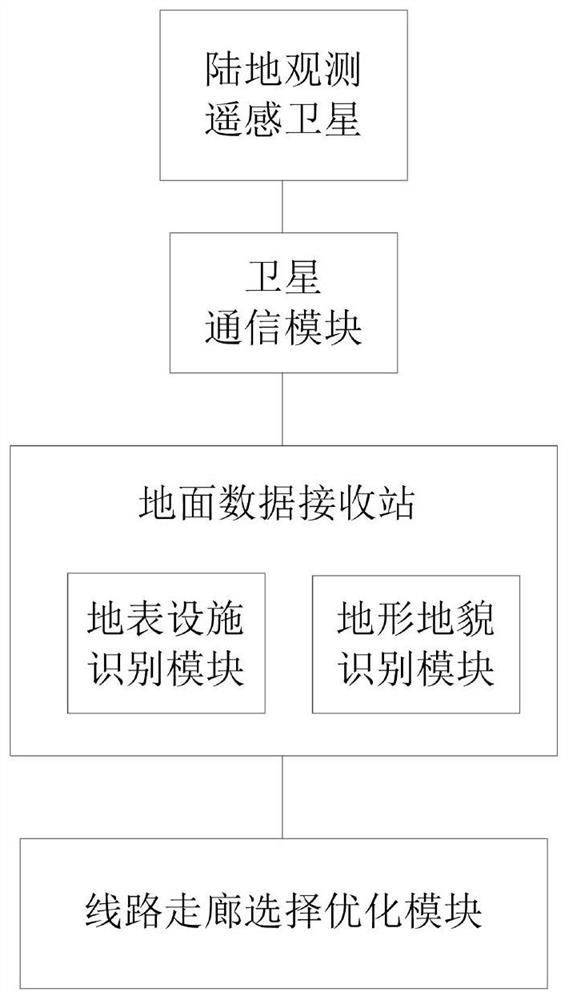
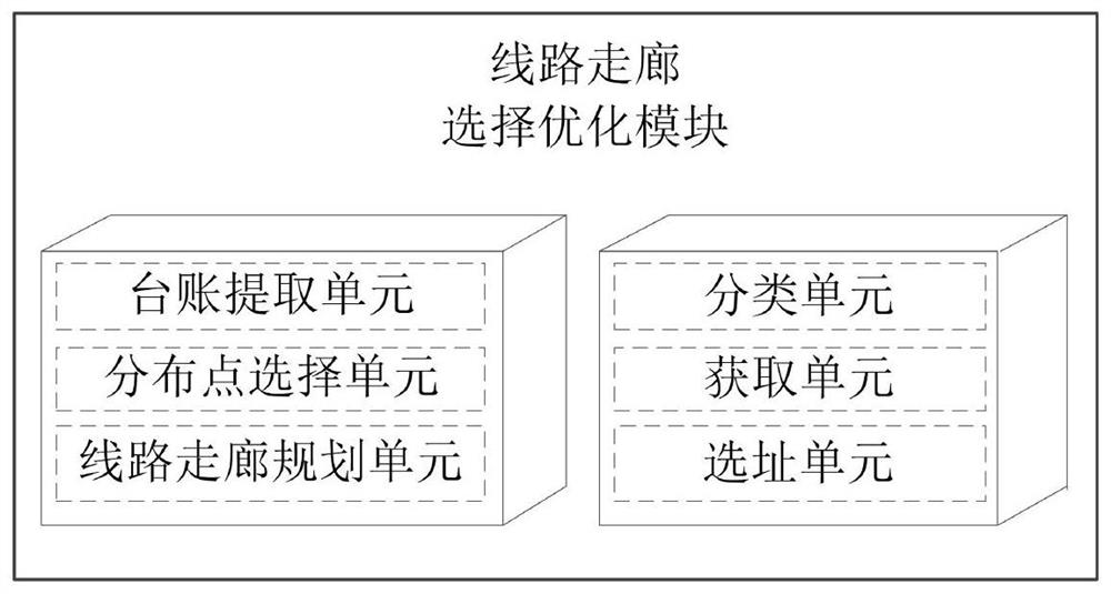
[0043] Such as figure 1 As shown, it is a schematic diagram of the overall structure of a transmission tower site selection optimization system based on satellite remote sensing identification provided by the embodiment of the present application. The first aspect of the embodiment of the present application provides a transmission tower site selection optimization system based on satellite remote sensing identification , comprising: a land observation remote sensing satellite, a satellite communication module, a ground data receiving station and a line corridor selection and optimization module, and the ground data receiving s...


PUM


Abstract

The invention relates to the technical field of power grid construction, and provides a transmission tower site selection optimization system and method based on satellite remote sensing recognition, and the transmission tower site selection optimization system comprises a land observation remote sensing satellite, a satellite communication module, a ground data receiving station, and a line corridor selection optimization module. The ground data receiving station is also provided with a ground surface facility identification module and a landform identification module. In an actual application process, a target area image is acquired; then surface facilities and distribution points of the surface facilities in the target area image are identified, and topographic and geomorphic features in the target area image are identified; a pre-planned transmission line corridor is generated according to the ground surface facilities and the distribution points of the ground surface facilities; and finally, according to the topographic and geomorphic characteristics, power transmission tower site selection distribution in the pre-planned power transmission line corridor is determined, and a final power grid power transmission line is generated, so that the power grid line planning period can be shortened, the power grid line planning efficiency can be improved, and the development speed of power grid construction can be accelerated.

Description

technical field [0001] The present application relates to the technical field of power grid construction, in particular to a system and method for optimizing the site selection of power transmission towers based on satellite remote sensing identification. Background technique [0002] As an important material foundation and driving force for economic and social development, the electric power industry must develop rapidly and ahead of time. Optimize the power grid lines and further develop the power grid construction. [0003] The existing grid line planning is based on load forecasting and power supply planning. The grid line planning determines when and where to invest and build what type of transmission line and the number of circuits to achieve the required transmission capacity within the planning period. Under the premise of meeting various technical indicators, it must operate economically and safely. [0004] However, in the actual grid line planning, due to the la...

Claims


Application Information

Patent Timeline
Patent Type & Authority Applications(China)
IPC IPC(8): G06Q10/04G06Q50/06
CPCG06Q10/043G06Q50/06Y04S10/50
Inventor 周仿荣王韧孙再超文刚沈志金晶孙董军陆正豪
Owner YUNNAN POWER GRID CO LTD ELECTRIC POWER RES INST
Why Eureka
Try Eureka