Urban building material classification method fusing multi-source satellite remote sensing data

A satellite remote sensing data and classification method technology, which is applied in the field of urban building material classification, can solve problems such as incomplete boundaries, missing building spatial geometry, and different spectra of the same objects, so as to improve boundary accuracy, enhance application potential, high precision effect

Active Publication Date: 2021-06-04
北京观微科技有限公司
View PDF4 Cites 1 Cited by
  • Summary
  • Abstract
  • Description
  • Claims
  • Application Information

AI Technical Summary

Problems solved by technology

However, due to the prevalence of individual differences in urban buildings, different spectra of the same object and the same spectrum of different objects, the spectrum of a certain point on the surface of the building is not representative.
In addition, the spatia

Method used


Image

  • Urban building material classification method fusing multi-source satellite remote sensing data

Examples


Embodiment Construction

[0026] The following will clearly and completely describe the technical solutions in the embodiments of the present invention with reference to the accompanying drawings in the embodiments of the present invention. Obviously, the described embodiments are only some, not all, embodiments of the present invention. Based on the embodiments of the present invention, all other embodiments obtained by persons of ordinary skill in the art without making creative efforts belong to the protection scope of the present invention.

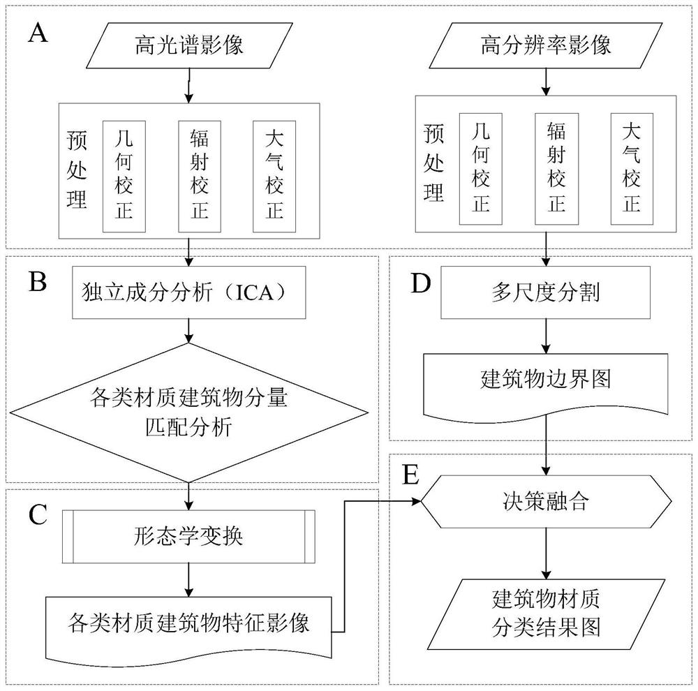
[0027] Such as figure 1 , a method for classifying urban building materials by fusing multi-source satellite remote sensing data, the steps include,

[0028] S1: Preprocessing hyperspectral images and high-resolution images;

[0029] S2: Perform independent component analysis on the preprocessed hyperspectral image, and perform matching analysis with the building material to obtain the independent component image of the building material;

[0030] S3: Perfor...


PUM


Abstract

An urban building material classification method fusing multi-source satellite remote sensing data comprises the following steps: S1, preprocessing a hyperspectral image and a high-resolution image; S2, carrying out independent component analysis on the preprocessed hyperspectral image to obtain an independent component, and carrying out matching analysis on the independent component and a building material to obtain a building material independent component image; S3, performing morphological transformation on the building material independent component images to obtain various building material feature images; S4, performing multi-scale segmentation on the preprocessed high-resolution image to obtain a building boundary image; S5, subjecting the building material feature image and the building boundary image to decision fusion to acquire a building material classification result. The hyperspectral image and the high-resolution image are fused to achieve building material classification, the accuracy of the classification result is improved, and the problems of geometric shape missing, boundary incompleteness and the like are solved.

Description

technical field [0001] The invention belongs to the technical field of remote sensing image processing, and more specifically relates to a method for classifying urban building materials by fusing multi-source satellite remote sensing data. Background technique [0002] Urban buildings are an important part of the city and a stable space for human habitation and daily activities. Rapid and accurate acquisition of urban building material information plays an important role in urban surveys, urban planning, urban management, disaster assessment and natural disaster compensation. With the continuous development of social economy and increasing human activities, the material information of urban buildings has attracted more and more attention. The traditional method of material classification of urban buildings is generally manual field survey, which wastes a lot of manpower and material resources and is inefficient. [0003] With the rapid development of technologies such as ...

Claims


Application Information

Patent Timeline
IPC IPC(8): G06K9/00G06K9/62
CPCG06V20/176G06F18/2134G06F18/22G06F18/241G06F18/253
Inventor 汪磊管雪华李梦薇殷继先史静李强李健存谢永虎
Owner 北京观微科技有限公司
Why Eureka
Try Eureka