Topographic image suitability analysis method and device and readable storage medium
An analysis method and adaptive technology, applied in the field of image analysis, can solve the problem of high complexity in the analysis process and achieve the effect of reducing complexity
- Summary
- Abstract
- Description
- Claims
- Application Information
AI Technical Summary
Problems solved by technology
Method used
Image
Examples
Embodiment Construction
[0045] It should be understood that the specific embodiments described herein are merely intended to illustrate the invention and are not intended to limit the invention.
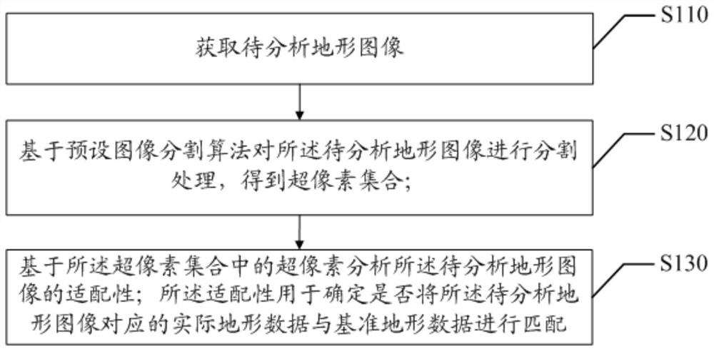
[0046] The present invention provides a method of adaptivity analysis of terrain images, reference figure 1 , figure 1 A flow diagram of the first embodiment of the terrain image adaptivity analysis method of the present invention.
[0047] The embodiment of the present invention provides an embodiment of a terrain image adaptivity analysis method, and it is to be noted that although a logical order is shown in the flowchart, in some cases, the order can be performed in the order here. The steps shown or described. Topographic image adaptation analysis method can be applied to the terminal, including but not limited to personal computers, etc. For ease of description, the implementation of the main body describes the terrain image adaptivity analysis method. Topographic image adaptation analysis methods include...
PUM
 Abstract
Description
Claims
Application Information
 - R&D
- Intellectual Property
- Life Sciences
- Materials
- Tech Scout
- Unparalleled Data Quality
- Higher Quality Content
- 60% Fewer Hallucinations
Browse by: Latest US Patents, China's latest patents, Technical Efficacy Thesaurus, Application Domain, Technology Topic, Popular Technical Reports.
© 2025 PatSnap. All rights reserved.Legal|Privacy policy|Modern Slavery Act Transparency Statement|Sitemap|About US| Contact US: help@patsnap.com


